Madagali elevation
Madagali (Adamawa), Nigeria elevation is 503 meters and Madagali elevation in feet is 1650 ft above sea level [src 1]. Madagali is a populated place (feature code) with elevation that is 206 meters (676 ft) bigger than average city elevation in Nigeria.
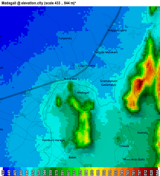
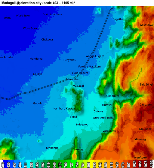
Below is the Elevation map of Madagali, which displays elevation range with different colors. Scale of the first map is from 433 to 844 m (1421 to 2769 ft) with average elevation of 507.2 meters (=1664 ft) [note 1]
These maps also provides idea of topography and contour of this city, they are displayed at different zoom levels. More info about maps, scale and edge coordinates you can find below images.
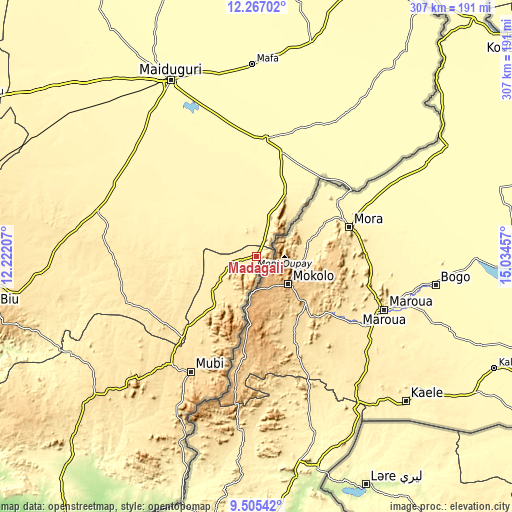
| \ | Map #1 | Map #2 | Topo.Map |
| Scale [m] | 433..844 m | 403..1105 m | × |
| Scale [ft] | 1421..2769 ft | 1322..3625 ft | × |
| Average | 507.2 m = 1664 ft | 590.4 m = 1937 ft | × |
| Width | 9.6 km = 6 mi | 19.19 km = 11.9 mi | 307.1 km = 190.8 mi |
| Height | 9.6 km = 6 mi | 19.19 km = 11.9 mi | 307.1 km = 190.8 mi |
| ↑Max Latitude | 10.932571° | 10.975715° | 12.26702° |
| Latitude at center | 10.88942° | 10.88942° | 10.88942° |
| ↓Min Latitude | 10.846263° | 10.803099° | 9.50542° |
| ← Min Longitude | 13.584375° | 13.540429° | 12.22207° |
| Longitude center | 13.62832° | 13.62832° | 13.62832° |
| →Max Longitude | 13.672265° | 13.716211° | 15.03457° |
Nearby cities:
Cities around Madagali sort by population:
• Mubi elevation 582 m
79.5 km,  209°
209°
• Bama 330 m
70.6 km,  5°
5°
• Damboa 401 m
99.6 km,  287°
287°
• Gwoza 418 m
22.8 km,  18°
18°
• Konduga 330 m
88 km,  344°
344°
• Uba 496 m
65.6 km,  222°
222°
• Tokombere 360 m
40 km, 337°
• Gella 812 m
89 km,  203°
203°
• Chibok 464 m
85.4 km,  268°
268°
• Askira 467 m
82.9 km,  251°
251°
• Michika 528 m
39.7 km, 221°
• Gulak 488 m
20.8 km,  243°
243°
Multilingual:
 En español:
Madagali elevación 503 m.
 En France:
Madagali élévation 503 m.
 Auf Deutsch:
Madagali höhe über dem Meeresspiegel ist 503 m.

Sources and notes:
- [note 1] Map square and city borders are not equal. Map elevation data is calculated only from area inside that square.
- [src 1] Elevation data from geonames database provided with same terms of usage.
- [src 2] The elevation map of Madagali is generated using elevation data from NASA's 3 arcsec (90m) resolution SRTM data.
- [src 3] Base (background) map © OpenStreetMap contributors tiles are generated by Geofabrik and OpenTopoMap.
Copyright & License:
This Madagali Elevation Map is licensed under CC BY-SA. You may reuse any part from this page, if you give a proper credit by linking to this URL:
 More info on terms of use page.