Bauchi elevation
Bauchi, Nigeria elevation is 623 meters and Bauchi elevation in feet is 2044 ft above sea level [src 1]. Bauchi is a seat of a first-order administrative division (feature code) with elevation that is 326 meters (1070 ft) bigger than average city elevation in Nigeria.
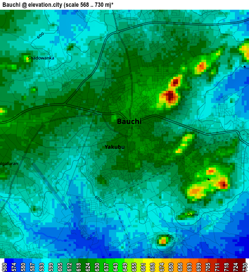
Below is the Elevation map of Bauchi, which displays elevation range with different colors. Scale of the first map is from 568 to 730 m (1864 to 2395 ft) with average elevation of 608 meters (=1995 ft) [note 1]
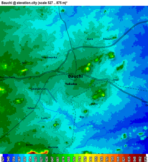
These maps also provides idea of topography and contour of this city, they are displayed at different zoom levels. More info about maps, scale and edge coordinates you can find below images.
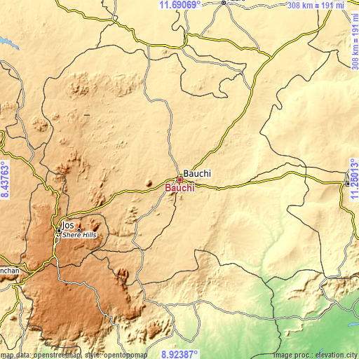
| \ | Map #1 | Map #2 | Topo.Map |
| Scale [m] | 568..730 m | 527..875 m | × |
| Scale [ft] | 1864..2395 ft | 1729..2871 ft | × |
| Average | 608 m = 1995 ft | 597.6 m = 1961 ft | × |
| Width | 9.61 km = 6 mi | 19.23 km = 11.9 mi | 307.6 km = 191.1 mi |
| Height | 9.61 km = 6 mi | 19.23 km = 11.9 mi | 307.7 km = 191.2 mi |
| ↑Max Latitude | 10.353553° | 10.39678° | 11.69069° |
| Latitude at center | 10.31032° | 10.31032° | 10.31032° |
| ↓Min Latitude | 10.267081° | 10.223837° | 8.92387° |
| ← Min Longitude | 9.799935° | 9.755989° | 8.43763° |
| Longitude center | 9.84388° | 9.84388° | 9.84388° |
| →Max Longitude | 9.887825° | 9.931771° | 11.25013° |
Nearby cities:
Cities around Bauchi sort by population:
• Dindima elevation 470 m
34.9 km,  105°
105°
• Zalanga 554 m
49.6 km,  47°
47°
• Dass 617 m
49.7 km,  226°
226°
• Yamrat 553 m
22.2 km,  185°
185°
• Lame 711 m
67.7 km,  282°
282°
• Gwaram 447 m
49.1 km,  100°
100°
• Bununu 579 m
50.8 km,  200°
200°
• Bogoro 695 m
75.9 km, 200°
• Tafawa Balewa 655 m
69 km,  207°
207°
• Kirfi 361 m
62.2 km,  80°
80°
• Alkaleri 397 m
53.7 km, 95°
• Kafin Madaki 556 m
43 km,  347°
347°
Multilingual:
 En español:
Bauchi elevación 623 m.
 En France:
Bauchi élévation 623 m.


Sources and notes:
- [note 1] Map square and city borders are not equal. Map elevation data is calculated only from area inside that square.
- [src 1] Elevation data from geonames database provided with same terms of usage.
- [src 2] The elevation map of Bauchi is generated using elevation data from NASA's 3 arcsec (90m) resolution SRTM data.
- [src 3] Base (background) map © OpenStreetMap contributors tiles are generated by Geofabrik and OpenTopoMap.
Copyright & License:
This Bauchi Elevation Map is licensed under CC BY-SA. You may reuse any part from this page, if you give a proper credit by linking to this URL:
 More info on terms of use page.