Daura elevation
Daura (Yobe, Fune), Nigeria elevation is 484 meters and Daura elevation in feet is 1588 ft above sea level [src 1]. Daura is a populated place (feature code) with elevation that is 187 meters (614 ft) bigger than average city elevation in Nigeria.
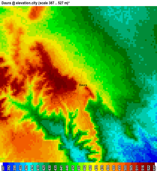
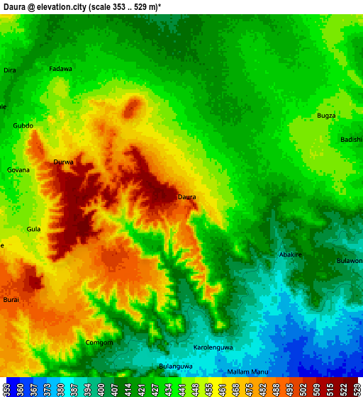
Below is the Elevation map of Daura, which displays elevation range with different colors. Scale of the first map is from 387 to 527 m (1270 to 1729 ft) with average elevation of 455.5 meters (=1494 ft) [note 1]
These maps also provides idea of topography and contour of this city, they are displayed at different zoom levels. More info about maps, scale and edge coordinates you can find below images.
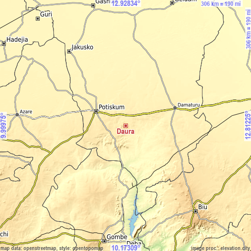
| \ | Map #1 | Map #2 | Topo.Map |
| Scale [m] | 387..527 m | 353..529 m | × |
| Scale [ft] | 1270..1729 ft | 1158..1736 ft | × |
| Average | 455.5 m = 1494 ft | 436 m = 1430 ft | × |
| Width | 9.57 km = 5.9 mi | 19.15 km = 11.9 mi | 306.4 km = 190.4 mi |
| Height | 9.57 km = 5.9 mi | 19.15 km = 11.9 mi | 306.4 km = 190.4 mi |
| ↑Max Latitude | 11.597151° | 11.640196° | 12.92834° |
| Latitude at center | 11.5541° | 11.5541° | 11.5541° |
| ↓Min Latitude | 11.511042° | 11.467977° | 10.17309° |
| ← Min Longitude | 11.362055° | 11.318109° | 9.99975° |
| Longitude center | 11.406° | 11.406° | 11.406° |
| →Max Longitude | 11.449945° | 11.493891° | 12.81225° |
Nearby cities:
Cities around Daura sort by population:
• Potiskum elevation 427 m
39.6 km,  296°
296°
• Damaturu 371 m
64.1 km,  70°
70°
• Nafada 275 m
51.6 km,  188°
188°
• Gujba 420 m
57.8 km,  96°
96°
• Lajere 366 m
47.5 km,  4°
4°
• Yanda Bayo 455 m
72.1 km,  265°
265°
• Dambam 397 m
77.3 km,  280°
280°
• Bara 289 m
75 km,  156°
156°
• Buni Yadi 443 m
72.7 km,  115°
115°
• Sabon Garin Nangere 394 m
48.9 km,  312°
312°
• Fika 381 m
31.6 km,  199°
199°
• Damagum 416 m
15.8 km,  330°
330°
Multilingual:
 En español:
Daura elevación 484 m.
 En France:
Daura élévation 484 m.


Sources and notes:
- [note 1] Map square and city borders are not equal. Map elevation data is calculated only from area inside that square.
- [src 1] Elevation data from geonames database provided with same terms of usage.
- [src 2] The elevation map of Daura is generated using elevation data from NASA's 3 arcsec (90m) resolution SRTM data.
- [src 3] Base (background) map © OpenStreetMap contributors tiles are generated by Geofabrik and OpenTopoMap.
Copyright & License:
This Daura Elevation Map is licensed under CC BY-SA. You may reuse any part from this page, if you give a proper credit by linking to this URL:
 More info on terms of use page.