Nafada elevation
Nafada (Gombe), Nigeria elevation is 275 meters and Nafada elevation in feet is 902 ft above sea level [src 1]. Nafada is a seat of a second-order administrative division (feature code) with elevation that is 22 meters (72 ft) smaller than average city elevation in Nigeria.
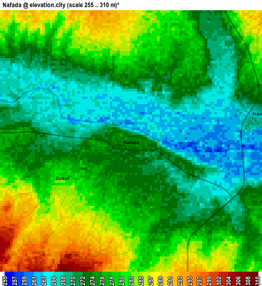
Below is the Elevation map of Nafada, which displays elevation range with different colors. Scale of the first map is from 255 to 310 m (837 to 1017 ft) with average elevation of 276.2 meters (=906 ft) [note 1]
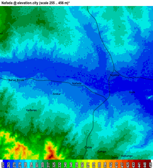
These maps also provides idea of topography and contour of this city, they are displayed at different zoom levels. More info about maps, scale and edge coordinates you can find below images.
| \ | Map #1 | Map #2 | Topo.Map |
| Scale [m] | 255..310 m | 255..456 m | × |
| Scale [ft] | 837..1017 ft | 837..1496 ft | × |
| Average | 276.2 m = 906 ft | 291.7 m = 957 ft | × |
| Width | 9.59 km = 6 mi | 19.18 km = 11.9 mi | 306.8 km = 190.6 mi |
| Height | 9.59 km = 6 mi | 19.18 km = 11.9 mi | 306.9 km = 190.7 mi |
| ↑Max Latitude | 11.139081° | 11.182195° | 12.47254° |
| Latitude at center | 11.09596° | 11.09596° | 11.09596° |
| ↓Min Latitude | 11.052833° | 11.0097° | 9.71287° |
| ← Min Longitude | 11.288665° | 11.244719° | 9.92636° |
| Longitude center | 11.33261° | 11.33261° | 11.33261° |
| →Max Longitude | 11.376555° | 11.420501° | 12.73886° |
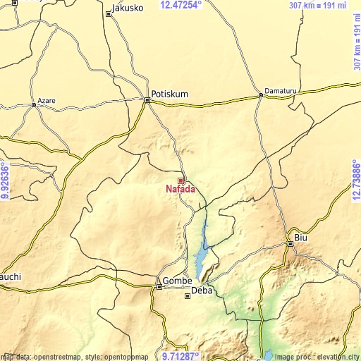
Nearby cities:
Cities around Nafada sort by population:
• Potiskum elevation 427 m
74 km,  338°
338°
• Daura 484 m
51.6 km,  8°
8°
• Dukku 474 m
68.3 km,  243°
243°
• Gujba 420 m
79.5 km,  55°
55°
• Sade 414 m
77.7 km,  292°
292°
• Yanda Bayo 455 m
78.6 km,  305°
305°
• Buni Yadi 443 m
76.3 km,  74°
74°
• Mallam Sidi 326 m
69.9 km,  183°
183°
• Damagum 416 m
64.7 km,  0°
0°
• Bara 289 m
42.1 km,  114°
114°
• Bajoga 294 m
29.3 km,  158°
158°
• Fika 381 m
21.4 km,  352°
352°
Multilingual:
 En español:
Nafada elevación 275 m.
 En France:
Nafada élévation 275 m.


Sources and notes:
- [note 1] Map square and city borders are not equal. Map elevation data is calculated only from area inside that square.
- [src 1] Elevation data from geonames database provided with same terms of usage.
- [src 2] The elevation map of Nafada is generated using elevation data from NASA's 3 arcsec (90m) resolution SRTM data.
- [src 3] Base (background) map © OpenStreetMap contributors tiles are generated by Geofabrik and OpenTopoMap.
Copyright & License:
This Nafada Elevation Map is licensed under CC BY-SA. You may reuse any part from this page, if you give a proper credit by linking to this URL:
 More info on terms of use page.