Garko elevation
Garko (Gombe, Akko), Nigeria elevation is 470 meters and Garko elevation in feet is 1542 ft above sea level [src 1]. Garko is a populated place (feature code) with elevation that is 173 meters (568 ft) bigger than average city elevation in Nigeria.
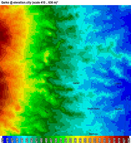
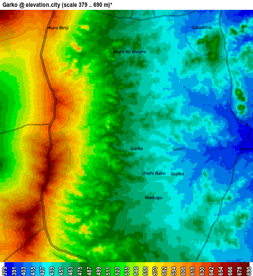
Below is the Elevation map of Garko, which displays elevation range with different colors. Scale of the first map is from 410 to 636 m (1345 to 2087 ft) with average elevation of 485.1 meters (=1592 ft) [note 1]
These maps also provides idea of topography and contour of this city, they are displayed at different zoom levels. More info about maps, scale and edge coordinates you can find below images.
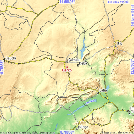
| \ | Map #1 | Map #2 | Topo.Map |
| Scale [m] | 410..636 m | 379..690 m | × |
| Scale [ft] | 1345..2087 ft | 1243..2264 ft | × |
| Average | 485.1 m = 1592 ft | 495.1 m = 1624 ft | × |
| Width | 9.62 km = 6 mi | 19.24 km = 12 mi | 307.8 km = 191.3 mi |
| Height | 9.62 km = 6 mi | 19.24 km = 12 mi | 307.8 km = 191.3 mi |
| ↑Max Latitude | 10.218311° | 10.261557° | 11.55606° |
| Latitude at center | 10.17506° | 10.17506° | 10.17506° |
| ↓Min Latitude | 10.131803° | 10.08854° | 8.78806° |
| ← Min Longitude | 11.120635° | 11.076689° | 9.75833° |
| Longitude center | 11.16458° | 11.16458° | 11.16458° |
| →Max Longitude | 11.208525° | 11.252471° | 12.57083° |
Nearby cities:
Cities around Garko sort by population:
• Gombe elevation 460 m
12.7 km,  1°
1°
• Pindiga 490 m
31.5 km,  227°
227°
• Kumo 427 m
15 km,  160°
160°
• Deba 311 m
24.7 km,  80°
80°
• Billiri 529 m
35.1 km,  168°
168°
• Kaltungo 489 m
42.5 km, 158°
• Kafarati 496 m
24.3 km,  341°
341°
• Hinna 221 m
39.3 km,  68°
68°
• Akko 615 m
24.5 km,  301°
301°
• Boh 568 m
45.5 km, 164°
• Mallam Sidi 326 m
35.5 km,  23°
23°
• Billiri 463 m
32.2 km, 169°
Multilingual:
 En español:
Garko elevación 470 m.
 En France:
Garko élévation 470 m.


Sources and notes:
- [note 1] Map square and city borders are not equal. Map elevation data is calculated only from area inside that square.
- [src 1] Elevation data from geonames database provided with same terms of usage.
- [src 2] The elevation map of Garko is generated using elevation data from NASA's 3 arcsec (90m) resolution SRTM data.
- [src 3] Base (background) map © OpenStreetMap contributors tiles are generated by Geofabrik and OpenTopoMap.
Copyright & License:
This Garko Elevation Map is licensed under CC BY-SA. You may reuse any part from this page, if you give a proper credit by linking to this URL:
 More info on terms of use page.