Kaltungo elevation
Kaltungo (Gombe), Nigeria elevation is 489 meters and Kaltungo elevation in feet is 1604 ft above sea level [src 1]. Kaltungo is a seat of a second-order administrative division (feature code) with elevation that is 192 meters (630 ft) bigger than average city elevation in Nigeria.
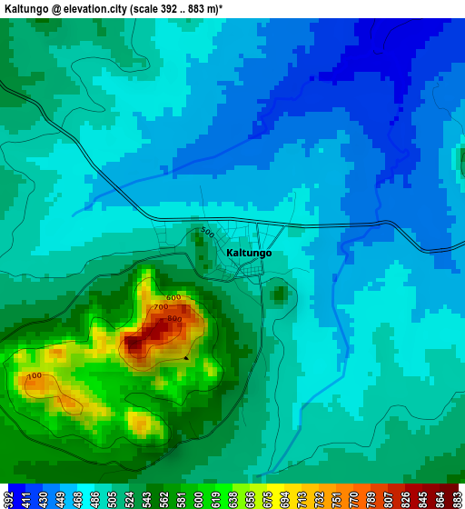
Below is the Elevation map of Kaltungo, which displays elevation range with different colors. Scale of the first map is from 392 to 883 m (1286 to 2897 ft) with average elevation of 502.3 meters (=1648 ft) [note 1]
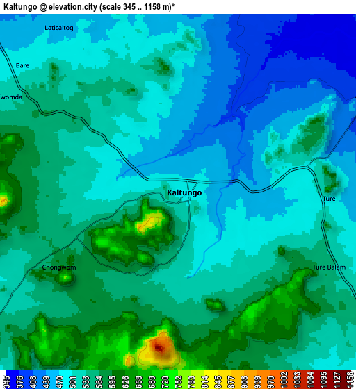
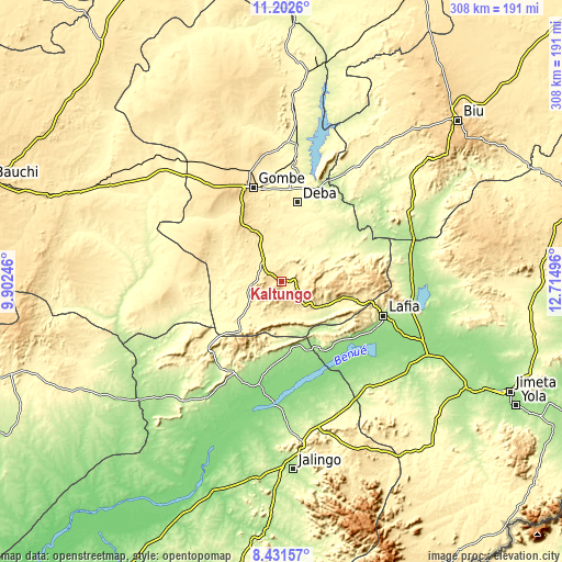
These maps also provides idea of topography and contour of this city, they are displayed at different zoom levels. More info about maps, scale and edge coordinates you can find below images.
| \ | Map #1 | Map #2 | Topo.Map |
| Scale [m] | 392..883 m | 345..1158 m | × |
| Scale [ft] | 1286..2897 ft | 1132..3799 ft | × |
| Average | 502.3 m = 1648 ft | 520.1 m = 1706 ft | × |
| Width | 9.63 km = 6 mi | 19.26 km = 12 mi | 308.1 km = 191.4 mi |
| Height | 9.63 km = 6 mi | 19.26 km = 12 mi | 308.1 km = 191.4 mi |
| ↑Max Latitude | 9.863279° | 9.906572° | 11.2026° |
| Latitude at center | 9.81998° | 9.81998° | 9.81998° |
| ↓Min Latitude | 9.776676° | 9.733366° | 8.43157° |
| ← Min Longitude | 11.264765° | 11.220819° | 9.90246° |
| Longitude center | 11.30871° | 11.30871° | 11.30871° |
| →Max Longitude | 11.352655° | 11.396601° | 12.71496° |
Nearby cities:
Cities around Kaltungo sort by population:
• Gombe elevation 460 m
54.5 km,  343°
343°
• Pindiga 490 m
43.1 km,  295°
295°
• Kumo 427 m
27.5 km, 337°
• Garko 470 m
42.5 km, 338°
• Deba 311 m
44.4 km,  11°
11°
• Billiri 529 m
10.4 km, 299°
• Hinna 221 m
57.7 km,  21°
21°
• Dadiya 349 m
26.4 km,  148°
148°
• Karim Lamido 144 m
57.8 km,  193°
193°
• Talasse 297 m
43.8 km,  67°
67°
• Billiri 463 m
12.6 km,  308°
308°
• Boh 568 m
5.4 km,  217°
217°
Multilingual:
 En español:
Kaltungo elevación 489 m.
 En France:
Kaltungo élévation 489 m.
 Auf Deutsch:
Kaltungo höhe über dem Meeresspiegel ist 489 m.

Sources and notes:
- [note 1] Map square and city borders are not equal. Map elevation data is calculated only from area inside that square.
- [src 1] Elevation data from geonames database provided with same terms of usage.
- [src 2] The elevation map of Kaltungo is generated using elevation data from NASA's 3 arcsec (90m) resolution SRTM data.
- [src 3] Base (background) map © OpenStreetMap contributors tiles are generated by Geofabrik and OpenTopoMap.
Copyright & License:
This Kaltungo Elevation Map is licensed under CC BY-SA. You may reuse any part from this page, if you give a proper credit by linking to this URL:
 More info on terms of use page.