Gwaram elevation
Gwaram (Jigawa), Nigeria elevation is 452 meters and Gwaram elevation in feet is 1483 ft above sea level [src 1]. Gwaram is a seat of a second-order administrative division (feature code) with elevation that is 155 meters (509 ft) bigger than average city elevation in Nigeria.
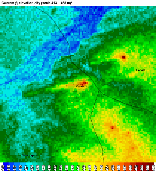
Below is the Elevation map of Gwaram, which displays elevation range with different colors. Scale of the first map is from 413 to 468 m (1355 to 1535 ft) with average elevation of 431.5 meters (=1416 ft) [note 1]
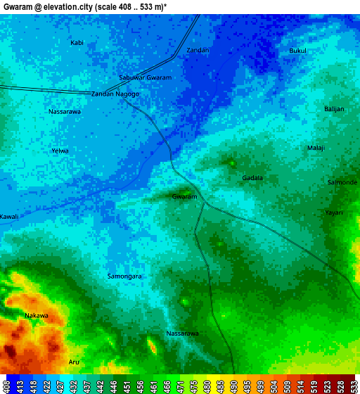
These maps also provides idea of topography and contour of this city, they are displayed at different zoom levels. More info about maps, scale and edge coordinates you can find below images.
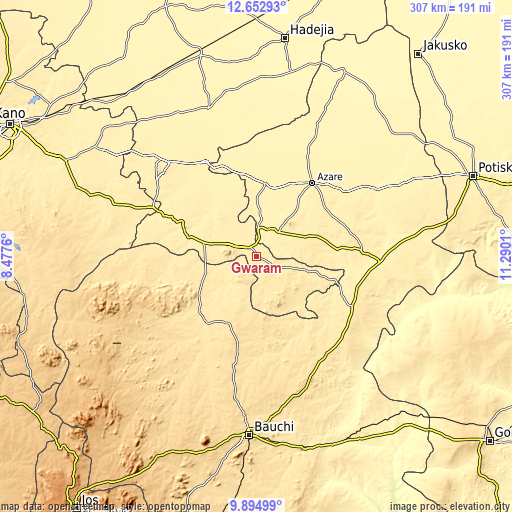
| \ | Map #1 | Map #2 | Topo.Map |
| Scale [m] | 413..468 m | 408..533 m | × |
| Scale [ft] | 1355..1535 ft | 1339..1749 ft | × |
| Average | 431.5 m = 1416 ft | 438.5 m = 1439 ft | × |
| Width | 9.58 km = 6 mi | 19.17 km = 11.9 mi | 306.7 km = 190.6 mi |
| Height | 9.58 km = 6 mi | 19.17 km = 11.9 mi | 306.7 km = 190.6 mi |
| ↑Max Latitude | 11.320364° | 11.363451° | 12.65293° |
| Latitude at center | 11.27727° | 11.27727° | 11.27727° |
| ↓Min Latitude | 11.23417° | 11.191063° | 9.89499° |
| ← Min Longitude | 9.839905° | 9.795959° | 8.4776° |
| Longitude center | 9.88385° | 9.88385° | 9.88385° |
| →Max Longitude | 9.927795° | 9.971741° | 11.2901° |
Nearby cities:
Cities around Gwaram sort by population:
• Azare elevation 413 m
55.4 km,  37°
37°
• Birnin Kudu 450 m
48.3 km,  293°
293°
• Misau 436 m
63.7 km,  86°
86°
• Samamiya 437 m
27.8 km, 286°
• Zadawa 435 m
56.1 km,  70°
70°
• Disina 415 m
23 km,  9°
9°
• Gantsa 404 m
46.2 km,  338°
338°
• Jama’are 398 m
43.9 km, 6°
• Ningi 497 m
40.9 km,  237°
237°
• Giade 465 m
36.7 km, 69°
• Yana 426 m
20.2 km, 44°
• Warji 451 m
18.1 km,  232°
232°
Multilingual:
 En español:
Gwaram elevación 452 m.
 En France:
Gwaram élévation 452 m.


Sources and notes:
- [note 1] Map square and city borders are not equal. Map elevation data is calculated only from area inside that square.
- [src 1] Elevation data from geonames database provided with same terms of usage.
- [src 2] The elevation map of Gwaram is generated using elevation data from NASA's 3 arcsec (90m) resolution SRTM data.
- [src 3] Base (background) map © OpenStreetMap contributors tiles are generated by Geofabrik and OpenTopoMap.
Copyright & License:
This Gwaram Elevation Map is licensed under CC BY-SA. You may reuse any part from this page, if you give a proper credit by linking to this URL:
 More info on terms of use page.