Misau elevation
Misau (Bauchi), Nigeria elevation is 436 meters and Misau elevation in feet is 1430 ft above sea level [src 1]. Misau is a seat of a second-order administrative division (feature code) with elevation that is 139 meters (456 ft) bigger than average city elevation in Nigeria.
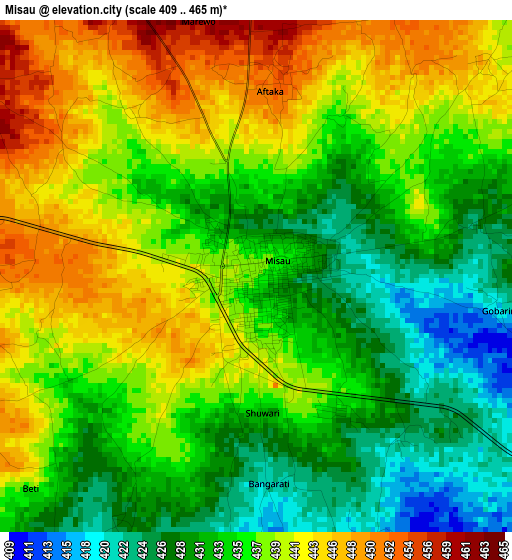
Below is the Elevation map of Misau, which displays elevation range with different colors. Scale of the first map is from 409 to 465 m (1342 to 1526 ft) with average elevation of 435.9 meters (=1430 ft) [note 1]
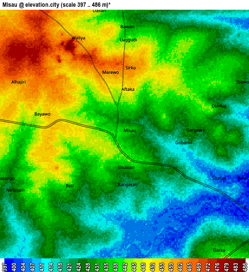
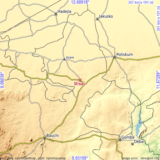
These maps also provides idea of topography and contour of this city, they are displayed at different zoom levels. More info about maps, scale and edge coordinates you can find below images.
| \ | Map #1 | Map #2 | Topo.Map |
| Scale [m] | 409..465 m | 397..486 m | × |
| Scale [ft] | 1342..1526 ft | 1302..1594 ft | × |
| Average | 435.9 m = 1430 ft | 433.4 m = 1422 ft | × |
| Width | 9.58 km = 6 mi | 19.17 km = 11.9 mi | 306.6 km = 190.5 mi |
| Height | 9.58 km = 6 mi | 19.17 km = 11.9 mi | 306.6 km = 190.5 mi |
| ↑Max Latitude | 11.356788° | 11.39987° | 12.68918° |
| Latitude at center | 11.3137° | 11.3137° | 11.3137° |
| ↓Min Latitude | 11.270605° | 11.227504° | 9.93159° |
| ← Min Longitude | 10.422695° | 10.378749° | 9.06039° |
| Longitude center | 10.46664° | 10.46664° | 10.46664° |
| →Max Longitude | 10.510585° | 10.554531° | 11.87289° |
Nearby cities:
Cities around Misau sort by population:
• Azare elevation 413 m
50.2 km,  323°
323°
• Kari 408 m
12.7 km,  125°
125°
• Darazo 507 m
35.5 km,  189°
189°
• Gabarin 478 m
22.9 km, 186°
• Madara 392 m
51.9 km,  357°
357°
• Sade 414 m
23.1 km,  77°
77°
• Zadawa 435 m
18.6 km, 324°
• Yanda Bayo 455 m
37.3 km,  54°
54°
• Disina 415 m
62.5 km,  287°
287°
• Yana 426 m
50.5 km,  281°
281°
• Dambam 397 m
48.4 km,  32°
32°
• Giade 465 m
30.3 km, 286°
Multilingual:
 En español:
Misau elevación 436 m.
 En France:
Misau élévation 436 m.


Sources and notes:
- [note 1] Map square and city borders are not equal. Map elevation data is calculated only from area inside that square.
- [src 1] Elevation data from geonames database provided with same terms of usage.
- [src 2] The elevation map of Misau is generated using elevation data from NASA's 3 arcsec (90m) resolution SRTM data.
- [src 3] Base (background) map © OpenStreetMap contributors tiles are generated by Geofabrik and OpenTopoMap.
Copyright & License:
This Misau Elevation Map is licensed under CC BY-SA. You may reuse any part from this page, if you give a proper credit by linking to this URL:
 More info on terms of use page.