Ikom elevation
Ikom (Cross River), Nigeria elevation is 60 meters and Ikom elevation in feet is 197 ft above sea level [src 1]. Ikom is a populated place (feature code) with elevation that is 237 meters (778 ft) smaller than average city elevation in Nigeria.
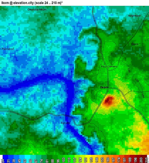
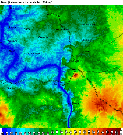
Below is the Elevation map of Ikom, which displays elevation range with different colors. Scale of the first map is from 24 to 210 m (79 to 689 ft) with average elevation of 74.9 meters (=246 ft) [note 1]
These maps also provides idea of topography and contour of this city, they are displayed at different zoom levels. More info about maps, scale and edge coordinates you can find below images.
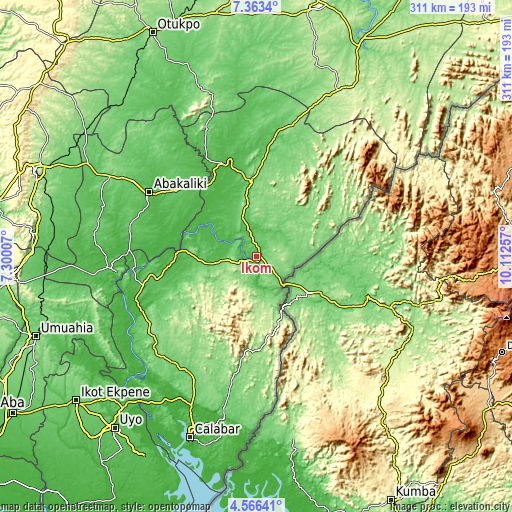
| \ | Map #1 | Map #2 | Topo.Map |
| Scale [m] | 24..210 m | 24..210 m | × |
| Scale [ft] | 79..689 ft | 79..689 ft | × |
| Average | 74.9 m = 246 ft | 88.4 m = 290 ft | × |
| Width | 9.72 km = 6 mi | 19.44 km = 12.1 mi | 311 km = 193.2 mi |
| Height | 9.72 km = 6 mi | 19.44 km = 12.1 mi | 311 km = 193.2 mi |
| ↑Max Latitude | 6.010395° | 6.054097° | 7.3634° |
| Latitude at center | 5.96669° | 5.96669° | 5.96669° |
| ↓Min Latitude | 5.922981° | 5.879269° | 4.56641° |
| ← Min Longitude | 8.662375° | 8.618429° | 7.30007° |
| Longitude center | 8.70632° | 8.70632° | 8.70632° |
| →Max Longitude | 8.750265° | 8.794211° | 10.11257° |
Nearby cities:
Cities around Ikom sort by population:
• Ugep elevation 101 m
71.4 km,  255°
255°
• Abakaliki 65 m
76.7 km,  301°
301°
• Ogoja 96 m
77.6 km,  7°
7°
• Obubra 91 m
43.1 km,  286°
286°
• Akpet Central 113 m
77.1 km,  240°
240°
• Onueke 91 m
76.9 km, 285°
• Itigidi 64 m
76.2 km, 263°
• Iboko 78 m
71.6 km,  313°
313°
• Okpoma 77 m
70.5 km,  353°
353°
• Onuebonyi Echara 56 m
63 km,  283°
283°
• Boje 142 m
42.5 km,  33°
33°
• Effraya 66 m
12.1 km,  171°
171°
Multilingual:
 En español:
Ikom elevación 60 m.
 En France:
Ikom élévation 60 m.


Sources and notes:
- [note 1] Map square and city borders are not equal. Map elevation data is calculated only from area inside that square.
- [src 1] Elevation data from geonames database provided with same terms of usage.
- [src 2] The elevation map of Ikom is generated using elevation data from NASA's 3 arcsec (90m) resolution SRTM data.
- [src 3] Base (background) map © OpenStreetMap contributors tiles are generated by Geofabrik and OpenTopoMap.
Copyright & License:
This Ikom Elevation Map is licensed under CC BY-SA. You may reuse any part from this page, if you give a proper credit by linking to this URL:
 More info on terms of use page.