Jahun elevation
Jahun (Jigawa), Nigeria elevation is 374 meters and Jahun elevation in feet is 1227 ft above sea level [src 1]. Jahun is a seat of a second-order administrative division (feature code) with elevation that is 77 meters (253 ft) bigger than average city elevation in Nigeria.
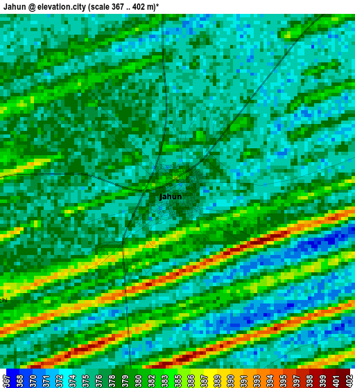
Below is the Elevation map of Jahun, which displays elevation range with different colors. Scale of the first map is from 367 to 402 m (1204 to 1319 ft) with average elevation of 377.9 meters (=1240 ft) [note 1]
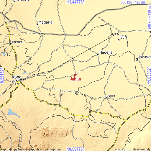
These maps also provides idea of topography and contour of this city, they are displayed at different zoom levels. More info about maps, scale and edge coordinates you can find below images.
| \ | Map #1 | Topo.Map |
| Scale [m] | 367..402 m | × |
| Scale [ft] | 1204..1319 ft | × |
| Average | 377.9 m = 1240 ft | × |
| Width | 9.56 km = 5.9 mi | 305.8 km = 190 mi |
| Height | 9.56 km = 5.9 mi | 305.8 km = 190 mi |
| ↑Max Latitude | 12.119259° | 13.44776° |
| Latitude at center | 12.07629° | 12.07629° |
| ↓Min Latitude | 12.033314° | 10.69776° |
| ← Min Longitude | 9.583625° | 8.22132° |
| Longitude center | 9.62757° | 9.62757° |
| →Max Longitude | 9.671515° | 11.03382° |
Nearby cities:
Cities around Jahun sort by population:
• Kiyawa elevation 395 m
32.5 km,  183°
183°
• Dutse 444 m
47.5 km,  221°
221°
• Ringim 392 m
51.3 km,  279°
279°
• Kafin Hausa 364 m
35.8 km,  59°
59°
• Gagarawa 374 m
38.5 km,  343°
343°
• Jama’are 398 m
55.8 km,  144°
144°
• Gantsa 404 m
47.2 km,  166°
166°
• Kaugama 366 m
45.8 km,  14°
14°
• Auyo 364 m
44.3 km,  49°
49°
• Itas 383 m
43.9 km,  123°
123°
• Taura 384 m
41 km,  294°
294°
• Miga 372 m
20.3 km,  27°
27°
Multilingual:
 En español:
Jahun elevación 374 m.
 En France:
Jahun élévation 374 m.


Sources and notes:
- [note 1] Map square and city borders are not equal. Map elevation data is calculated only from area inside that square.
- [src 1] Elevation data from geonames database provided with same terms of usage.
- [src 2] The elevation map of Jahun is generated using elevation data from NASA's 3 arcsec (90m) resolution SRTM data.
- [src 3] Base (background) map © OpenStreetMap contributors tiles are generated by Geofabrik and OpenTopoMap.
Copyright & License:
This Jahun Elevation Map is licensed under CC BY-SA. You may reuse any part from this page, if you give a proper credit by linking to this URL:
 More info on terms of use page.