Santa Lucía Ocotlán elevation
Santa Lucía Ocotlán (Oaxaca), Mexico elevation is 1524 meters and Santa Lucía Ocotlán elevation in feet is 5000 ft above sea level [src 1]. Santa Lucía Ocotlán is a seat of a second-order administrative division (feature code) with elevation that is 210 meters (689 ft) bigger than average city elevation in Mexico.
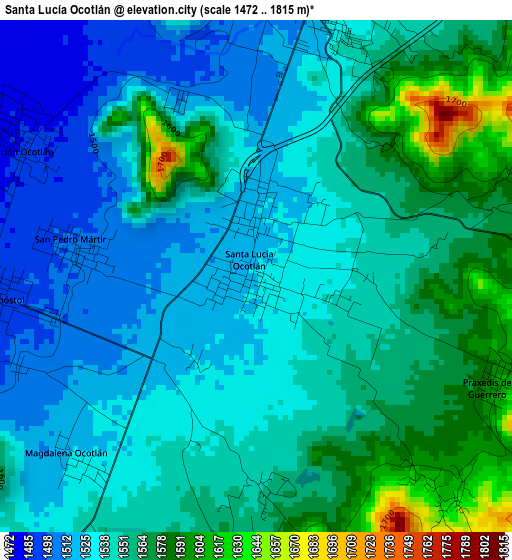
Below is the Elevation map of Santa Lucía Ocotlán, which displays elevation range with different colors. Scale of the first map is from 1472 to 1815 m (4829 to 5955 ft) with average elevation of 1546.1 meters (=5073 ft) [note 1]
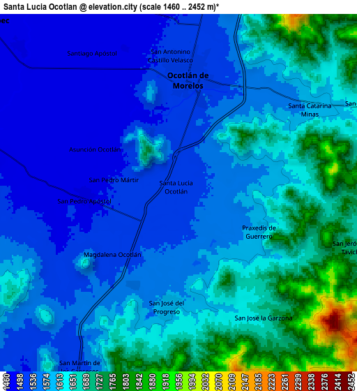
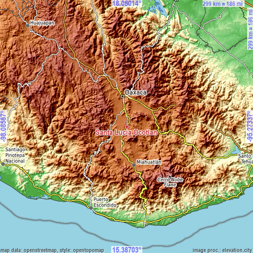
These maps also provides idea of topography and contour of this city, they are displayed at different zoom levels. More info about maps, scale and edge coordinates you can find below images.
| \ | Map #1 | Map #2 | Topo.Map |
| Scale [m] | 1472..1815 m | 1460..2452 m | × |
| Scale [ft] | 4829..5955 ft | 4790..8045 ft | × |
| Average | 1546.1 m = 5073 ft | 1604 m = 5262 ft | × |
| Width | 9.36 km = 5.8 mi | 18.72 km = 11.6 mi | 299.4 km = 186 mi |
| Height | 9.36 km = 5.8 mi | 18.72 km = 11.6 mi | 299.5 km = 186.1 mi |
| ↑Max Latitude | 16.780419° | 16.822488° | 18.08014° |
| Latitude at center | 16.73834° | 16.73834° | 16.73834° |
| ↓Min Latitude | 16.696252° | 16.654155° | 15.38703° |
| ← Min Longitude | -96.723565° | -96.767511° | -98.08587° |
| Longitude center | -96.67962° | -96.67962° | -96.67962° |
| →Max Longitude | -96.635675° | -96.591729° | -95.27337° |
Nearby cities:
Cities around Santa Lucía Ocotlán sort by population:
• Ocotlán de Morelos elevation 1523 m
5.9 km,  5°
5°
• San Antonino Castillo Velasco 1508 m
7 km,  357°
357°
• Santiago Apostol 1478 m
8.5 km,  329°
329°
• San José del Progreso 1591 m
5.8 km,  185°
185°
• Asunción Ocotlán 1485 m
5.2 km,  300°
300°
• Santa Catarina Minas 1580 m
8.2 km,  56°
56°
• San Pedro Martir 1500 m
3.4 km,  279°
279°
• San José la Garzona 1667 m
7.8 km,  145°
145°
• Praxedis de Guerrero 1593 m
4.7 km,  115°
115°
• San Pedro Apóstol 1494 m
4.8 km,  268°
268°
• Magdalena Ocotlán 1530 m
4.6 km,  224°
224°
• San Dionisio Ocotlán 1521 m
1 km, 357°
Multilingual:
 En español:
Santa Lucía Ocotlán elevación 1524 m.
 En France:
Santa Lucía Ocotlán élévation 1524 m.
 Auf Deutsch:
Santa Lucía Ocotlán höhe über dem Meeresspiegel ist 1524 m.
 На русском:
Santa Lucía Ocotlán высота над уровнем моря 1524 м
Sources and notes:
- [note 1] Map square and city borders are not equal. Map elevation data is calculated only from area inside that square.
- [src 1] Elevation data from geonames database provided with same terms of usage.
- [src 2] The elevation map of Santa Lucía Ocotlán is generated using elevation data from NASA's 3 arcsec (90m) resolution SRTM data.
- [src 3] Base (background) map © OpenStreetMap contributors tiles are generated by Geofabrik and OpenTopoMap.
Copyright & License:
This Santa Lucía Ocotlán Elevation Map is licensed under CC BY-SA. You may reuse any part from this page, if you give a proper credit by linking to this URL:
 More info on terms of use page.