San Antonino Castillo Velasco elevation
San Antonino Castillo Velasco (Oaxaca), Mexico elevation is 1508 meters and San Antonino Castillo Velasco elevation in feet is 4948 ft above sea level [src 1]. San Antonino Castillo Velasco is a seat of a second-order administrative division (feature code) with elevation that is 194 meters (636 ft) bigger than average city elevation in Mexico.
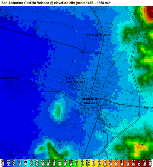
Below is the Elevation map of San Antonino Castillo Velasco, which displays elevation range with different colors. Scale of the first map is from 1469 to 1968 m (4820 to 6457 ft) with average elevation of 1525.7 meters (=5006 ft) [note 1]
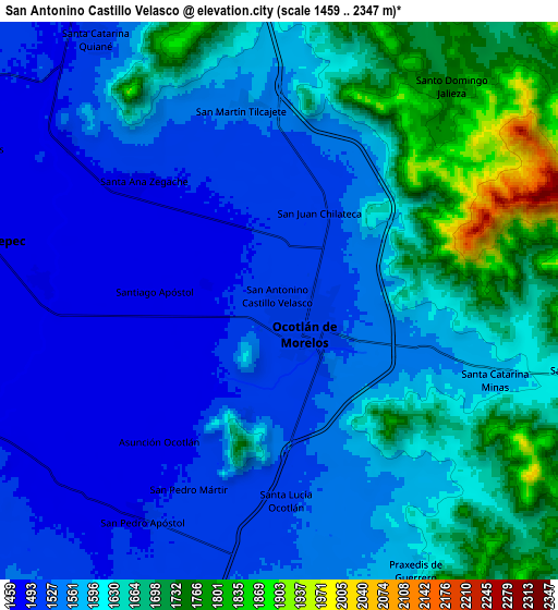
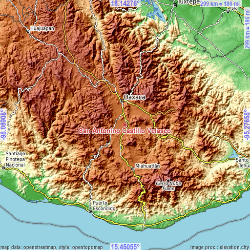
These maps also provides idea of topography and contour of this city, they are displayed at different zoom levels. More info about maps, scale and edge coordinates you can find below images.
| \ | Map #1 | Map #2 | Topo.Map |
| Scale [m] | 1469..1968 m | 1459..2347 m | × |
| Scale [ft] | 4820..6457 ft | 4787..7700 ft | × |
| Average | 1525.7 m = 5006 ft | 1591.3 m = 5221 ft | × |
| Width | 9.36 km = 5.8 mi | 18.71 km = 11.6 mi | 299.3 km = 186 mi |
| Height | 9.36 km = 5.8 mi | 18.71 km = 11.6 mi | 299.4 km = 186 mi |
| ↑Max Latitude | 16.843495° | 16.88555° | 18.14276° |
| Latitude at center | 16.80143° | 16.80143° | 16.80143° |
| ↓Min Latitude | 16.759356° | 16.717273° | 15.45055° |
| ← Min Longitude | -96.726775° | -96.770721° | -98.08908° |
| Longitude center | -96.68283° | -96.68283° | -96.68283° |
| →Max Longitude | -96.638885° | -96.594939° | -95.27658° |
Nearby cities:
Cities around San Antonino Castillo Velasco sort by population:
• Ocotlán de Morelos elevation 1523 m
1.4 km,  141°
141°
• Santiago Apostol 1478 m
4 km,  273°
273°
• Santa Lucía Ocotlán 1524 m
7 km,  177°
177°
• Santa Ana Zegache 1490 m
6.4 km,  308°
308°
• Asunción Ocotlán 1485 m
6 km,  223°
223°
• Santa Catarina Minas 1580 m
7.6 km,  108°
108°
• San Martín Tilcajete 1539 m
6.6 km,  348°
348°
• San Pedro Martir 1500 m
7.1 km,  204°
204°
• San Juan Chilateca 1512 m
3.5 km,  24°
24°
• Santo Tomás Jalieza 1522 m
5 km, 15°
• San Dionisio Ocotlán 1521 m
6.1 km, 177°
• Santa Inés Yatzeche 1475 m
7.9 km, 274°
Multilingual:
 En español:
San Antonino Castillo Velasco elevación 1508 m.
 En France:
San Antonino Castillo Velasco élévation 1508 m.
 Auf Deutsch:
San Antonino Castillo Velasco höhe über dem Meeresspiegel ist 1508 m.
 На русском:
San Antonino Castillo Velasco высота над уровнем моря 1508 м
Sources and notes:
- [note 1] Map square and city borders are not equal. Map elevation data is calculated only from area inside that square.
- [src 1] Elevation data from geonames database provided with same terms of usage.
- [src 2] The elevation map of San Antonino Castillo Velasco is generated using elevation data from NASA's 3 arcsec (90m) resolution SRTM data.
- [src 3] Base (background) map © OpenStreetMap contributors tiles are generated by Geofabrik and OpenTopoMap.
Copyright & License:
This San Antonino Castillo Velasco Elevation Map is licensed under CC BY-SA. You may reuse any part from this page, if you give a proper credit by linking to this URL:
 More info on terms of use page.