Tecoanapa elevation
Tecoanapa (Guerrero), Mexico elevation is 432 meters and Tecoanapa elevation in feet is 1417 ft above sea level [src 1]. Tecoanapa is a seat of a second-order administrative division (feature code) with elevation that is 882 meters (2894 ft) smaller than average city elevation in Mexico.
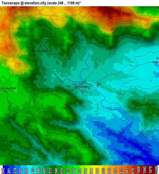
Below is the Elevation map of Tecoanapa, which displays elevation range with different colors. Scale of the first map is from 248 to 1108 m (814 to 3635 ft) with average elevation of 537.2 meters (=1762 ft) [note 1]
These maps also provides idea of topography and contour of this city, they are displayed at different zoom levels. More info about maps, scale and edge coordinates you can find below images.
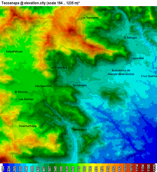
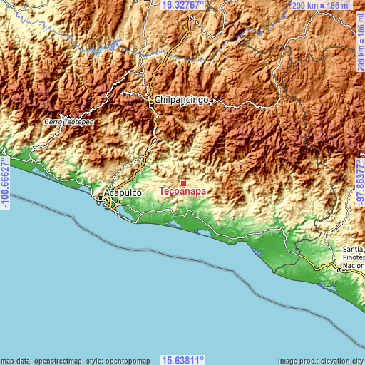
| \ | Map #1 | Map #2 | Topo.Map |
| Scale [m] | 248..1108 m | 184..1235 m | × |
| Scale [ft] | 814..3635 ft | 604..4052 ft | × |
| Average | 537.2 m = 1762 ft | 566.2 m = 1858 ft | × |
| Width | 9.35 km = 5.8 mi | 18.69 km = 11.6 mi | 299.1 km = 185.9 mi |
| Height | 9.35 km = 5.8 mi | 18.69 km = 11.6 mi | 299.1 km = 185.9 mi |
| ↑Max Latitude | 17.029733° | 17.071747° | 18.32767° |
| Latitude at center | 16.98771° | 16.98771° | 16.98771° |
| ↓Min Latitude | 16.945677° | 16.903635° | 15.63811° |
| ← Min Longitude | -99.303965° | -99.347911° | -100.66627° |
| Longitude center | -99.26002° | -99.26002° | -99.26002° |
| →Max Longitude | -99.216075° | -99.172129° | -97.85377° |
Nearby cities:
Cities around Tecoanapa sort by population:
• Xalpatláhuac elevation 710 m
8.5 km,  297°
297°
• Huamuchapa 727 m
8 km,  231°
231°
• Colotepec 427 m
7.8 km,  40°
40°
• Los Tepetates 734 m
8 km,  9°
9°
• El Pericón 648 m
7 km,  263°
263°
• Buenavista de Allende 387 m
5.2 km,  73°
73°
• Cruz Quemada 378 m
8.6 km,  82°
82°
• San Francisco 491 m
3.2 km,  309°
309°
• Las Ánimas 661 m
6.6 km, 255°
• Los Saucitos 625 m
4.3 km,  266°
266°
• Lagunillas 395 m
7.6 km, 66°
• El Refugio 411 m
8.5 km,  48°
48°
Multilingual:
 En español:
Tecoanapa elevación 432 m.
 En France:
Tecoanapa élévation 432 m.
 Auf Deutsch:
Tecoanapa höhe über dem Meeresspiegel ist 432 m.

Sources and notes:
- [note 1] Map square and city borders are not equal. Map elevation data is calculated only from area inside that square.
- [src 1] Elevation data from geonames database provided with same terms of usage.
- [src 2] The elevation map of Tecoanapa is generated using elevation data from NASA's 3 arcsec (90m) resolution SRTM data.
- [src 3] Base (background) map © OpenStreetMap contributors tiles are generated by Geofabrik and OpenTopoMap.
Copyright & License:
This Tecoanapa Elevation Map is licensed under CC BY-SA. You may reuse any part from this page, if you give a proper credit by linking to this URL:
 More info on terms of use page.