Xalpatláhuac elevation
Xalpatláhuac (Guerrero, Tecoanapa), Mexico elevation is 710 meters and Xalpatláhuac elevation in feet is 2329 ft above sea level [src 1]. Xalpatláhuac is a populated place (feature code) with elevation that is 604 meters (1982 ft) smaller than average city elevation in Mexico.
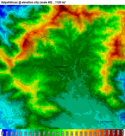
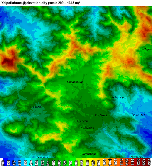
Below is the Elevation map of Xalpatláhuac, which displays elevation range with different colors. Scale of the first map is from 492 to 1120 m (1614 to 3675 ft) with average elevation of 750.3 meters (=2462 ft) [note 1]
These maps also provides idea of topography and contour of this city, they are displayed at different zoom levels. More info about maps, scale and edge coordinates you can find below images.
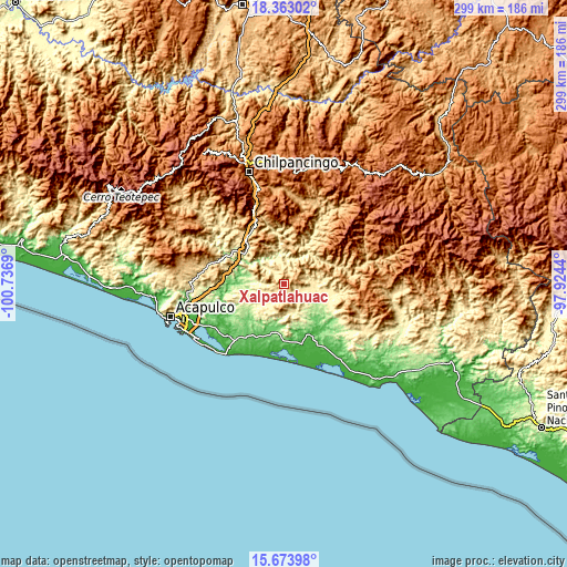
| \ | Map #1 | Map #2 | Topo.Map |
| Scale [m] | 492..1120 m | 299..1313 m | × |
| Scale [ft] | 1614..3675 ft | 981..4308 ft | × |
| Average | 750.3 m = 2462 ft | 673.4 m = 2209 ft | × |
| Width | 9.34 km = 5.8 mi | 18.69 km = 11.6 mi | 299 km = 185.8 mi |
| Height | 9.34 km = 5.8 mi | 18.69 km = 11.6 mi | 299 km = 185.8 mi |
| ↑Max Latitude | 17.065345° | 17.107351° | 18.36302° |
| Latitude at center | 17.02333° | 17.02333° | 17.02333° |
| ↓Min Latitude | 16.981305° | 16.939271° | 15.67398° |
| ← Min Longitude | -99.374595° | -99.418541° | -100.7369° |
| Longitude center | -99.33065° | -99.33065° | -99.33065° |
| →Max Longitude | -99.286705° | -99.242759° | -97.9244° |
Nearby cities:
Cities around Xalpatláhuac sort by population:
• Tecoanapa elevation 432 m
8.5 km,  117°
117°
• Huamuchapa 727 m
9 km,  171°
171°
• Los Tepetates 734 m
9.7 km,  65°
65°
• El Pericón 648 m
4.8 km, 173°
• El Limón 611 m
5.9 km,  238°
238°
• San Francisco 491 m
5.4 km,  111°
111°
• Las Ánimas 661 m
5.7 km, 168°
• Los Saucitos 625 m
5.3 km,  142°
142°
• Pochotillo 363 m
10.3 km,  268°
268°
• Villa Hermosa 762 m
9.4 km,  179°
179°
• Ocotlán 471 m
10.2 km,  203°
203°
• El Terrero 348 m
11.3 km,  350°
350°
Multilingual:
 En español:
Xalpatláhuac elevación 710 m.
 En France:
Xalpatláhuac élévation 710 m.
 Auf Deutsch:
Xalpatláhuac höhe über dem Meeresspiegel ist 710 m.

Sources and notes:
- [note 1] Map square and city borders are not equal. Map elevation data is calculated only from area inside that square.
- [src 1] Elevation data from geonames database provided with same terms of usage.
- [src 2] The elevation map of Xalpatláhuac is generated using elevation data from NASA's 3 arcsec (90m) resolution SRTM data.
- [src 3] Base (background) map © OpenStreetMap contributors tiles are generated by Geofabrik and OpenTopoMap.
Copyright & License:
This Xalpatláhuac Elevation Map is licensed under CC BY-SA. You may reuse any part from this page, if you give a proper credit by linking to this URL:
 More info on terms of use page.