La Ceja elevation
La Ceja (Querétaro, Huimilpan), Mexico elevation is 2299 meters and La Ceja elevation in feet is 7543 ft above sea level [src 1]. La Ceja is a populated place (feature code) with elevation that is 985 meters (3232 ft) bigger than average city elevation in Mexico.
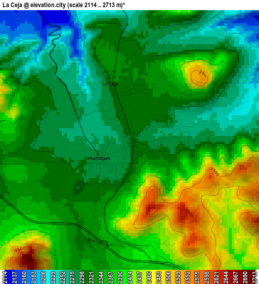
Below is the Elevation map of La Ceja, which displays elevation range with different colors. Scale of the first map is from 2114 to 2713 m (6936 to 8901 ft) with average elevation of 2342.7 meters (=7686 ft) [note 1]
These maps also provides idea of topography and contour of this city, they are displayed at different zoom levels. More info about maps, scale and edge coordinates you can find below images.
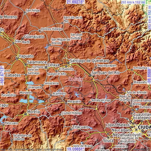
| \ | Map #1 | Topo.Map |
| Scale [m] | 2114..2713 m | × |
| Scale [ft] | 6936..8901 ft | × |
| Average | 2342.7 m = 7686 ft | × |
| Width | 9.16 km = 5.7 mi | 293.1 km = 182.1 mi |
| Height | 9.16 km = 5.7 mi | 293.1 km = 182.1 mi |
| ↑Max Latitude | 20.421449° | 21.69275° |
| Latitude at center | 20.38026° | 20.38026° |
| ↓Min Latitude | 20.33906° | 19.05651° |
| ← Min Longitude | -100.308995° | -101.6713° |
| Longitude center | -100.26505° | -100.26505° |
| →Max Longitude | -100.221105° | -98.8588° |
Nearby cities:
Cities around La Ceja sort by population:
• La D elevation 1962 m
13.5 km,  60°
60°
• Ajuchitlancito 1979 m
11.8 km,  25°
25°
• El Vegil 2052 m
10.5 km,  302°
302°
• Lagunillas 2152 m
9.3 km,  340°
340°
• Escolasticas 2119 m
7.7 km,  46°
46°
• Las Taponas 2075 m
13.1 km,  288°
288°
• El Milagro 1993 m
13.6 km,  320°
320°
• Los Cues 1999 m
13.5 km,  0°
0°
• Huimilpan 2294 m
1.6 km,  234°
234°
• San Pedro 2399 m
6.9 km,  197°
197°
• Ceja de Bravo 2171 m
13.5 km,  269°
269°
• San José Tepuzas 2229 m
11.9 km,  255°
255°
Multilingual:
 En español:
La Ceja elevación 2299 m.
 En France:
La Ceja élévation 2299 m.
 Auf Deutsch:
La Ceja höhe über dem Meeresspiegel ist 2299 m.

Sources and notes:
- [note 1] Map square and city borders are not equal. Map elevation data is calculated only from area inside that square.
- [src 1] Elevation data from geonames database provided with same terms of usage.
- [src 2] The elevation map of La Ceja is generated using elevation data from NASA's 3 arcsec (90m) resolution SRTM data.
- [src 3] Base (background) map © OpenStreetMap contributors tiles are generated by Geofabrik and OpenTopoMap.
Copyright & License:
This La Ceja Elevation Map is licensed under CC BY-SA. You may reuse any part from this page, if you give a proper credit by linking to this URL:
 More info on terms of use page.