Apantla elevation
Apantla (Guerrero, Ayutla de los Libres), Mexico elevation is 392 meters and Apantla elevation in feet is 1286 ft above sea level [src 1]. Apantla is a populated place (feature code) with elevation that is 922 meters (3025 ft) smaller than average city elevation in Mexico.
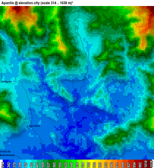
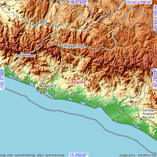
Below is the Elevation map of Apantla, which displays elevation range with different colors. Scale of the first map is from 314 to 1038 m (1030 to 3406 ft) with average elevation of 480.3 meters (=1576 ft) [note 1]
These maps also provides idea of topography and contour of this city, they are displayed at different zoom levels. More info about maps, scale and edge coordinates you can find below images.
| \ | Map #1 | Topo.Map |
| Scale [m] | 314..1038 m | × |
| Scale [ft] | 1030..3406 ft | × |
| Average | 480.3 m = 1576 ft | × |
| Width | 9.34 km = 5.8 mi | 299 km = 185.8 mi |
| Height | 9.34 km = 5.8 mi | 299 km = 185.8 mi |
| ↑Max Latitude | 17.081731° | 18.37929° |
| Latitude at center | 17.03972° | 17.03972° |
| ↓Min Latitude | 16.997699° | 15.69048° |
| ← Min Longitude | -99.213385° | -100.57569° |
| Longitude center | -99.16944° | -99.16944° |
| →Max Longitude | -99.125495° | -97.76319° |
Nearby cities:
Cities around Apantla sort by population:
• Ayutla de los Libres elevation 376 m
11.5 km,  137°
137°
• Tecoanapa 432 m
11.2 km,  239°
239°
• Colotepec 427 m
4.6 km,  271°
271°
• El Cortijo 359 m
6 km,  158°
158°
• Los Tepetates 734 m
8.5 km,  284°
284°
• Buenavista de Allende 387 m
6.4 km,  227°
227°
• San José la Hacienda 420 m
12.8 km,  121°
121°
• Cruz Quemada 378 m
4.8 km,  192°
192°
• San Francisco 491 m
12.7 km,  252°
252°
• Lagunillas 395 m
3.8 km,  224°
224°
• El Refugio 411 m
3.3 km, 267°
• Tutepec 196 m
13.2 km,  173°
173°
Multilingual:
 En español:
Apantla elevación 392 m.
 En France:
Apantla élévation 392 m.


Sources and notes:
- [note 1] Map square and city borders are not equal. Map elevation data is calculated only from area inside that square.
- [src 1] Elevation data from geonames database provided with same terms of usage.
- [src 2] The elevation map of Apantla is generated using elevation data from NASA's 3 arcsec (90m) resolution SRTM data.
- [src 3] Base (background) map © OpenStreetMap contributors tiles are generated by Geofabrik and OpenTopoMap.
Copyright & License:
This Apantla Elevation Map is licensed under CC BY-SA. You may reuse any part from this page, if you give a proper credit by linking to this URL:
 More info on terms of use page.