Tocoy elevation
Tocoy (San Luis Potosí, San Antonio), Mexico elevation is 260 meters and Tocoy elevation in feet is 853 ft above sea level [src 1]. Tocoy is a populated place (feature code) with elevation that is 1054 meters (3458 ft) smaller than average city elevation in Mexico.
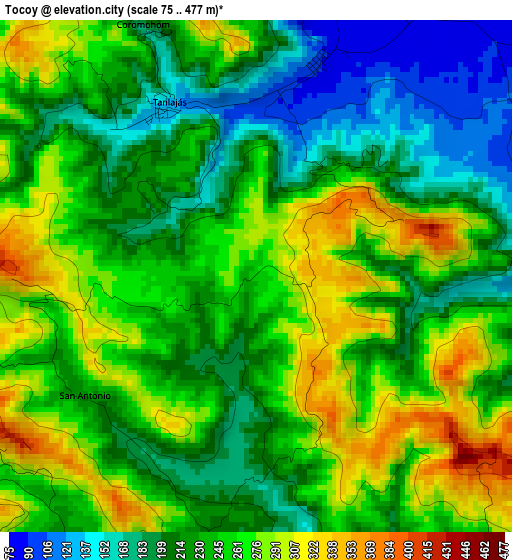
Below is the Elevation map of Tocoy, which displays elevation range with different colors. Scale of the first map is from 75 to 477 m (246 to 1565 ft) with average elevation of 238.9 meters (=784 ft) [note 1]
These maps also provides idea of topography and contour of this city, they are displayed at different zoom levels. More info about maps, scale and edge coordinates you can find below images.
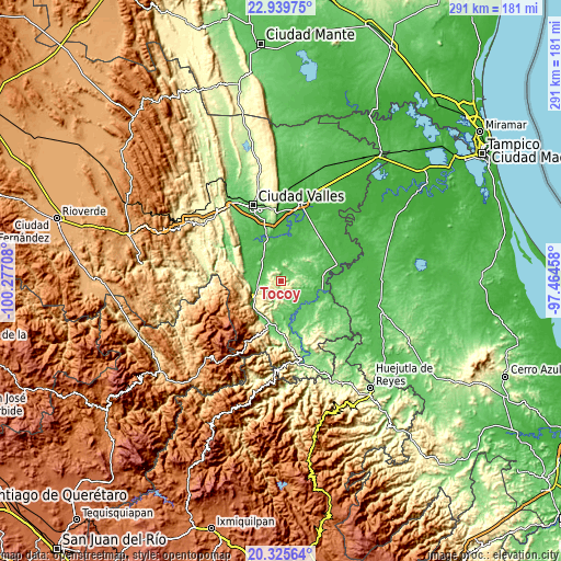
| \ | Map #1 | Topo.Map |
| Scale [m] | 75..477 m | × |
| Scale [ft] | 246..1565 ft | × |
| Average | 238.9 m = 784 ft | × |
| Width | 9.08 km = 5.6 mi | 290.7 km = 180.6 mi |
| Height | 9.08 km = 5.6 mi | 290.7 km = 180.6 mi |
| ↑Max Latitude | 21.679453° | 22.93975° |
| Latitude at center | 21.63861° | 21.63861° |
| ↓Min Latitude | 21.597756° | 20.32564° |
| ← Min Longitude | -98.914775° | -100.27708° |
| Longitude center | -98.87083° | -98.87083° |
| →Max Longitude | -98.826885° | -97.46458° |
Nearby cities:
Cities around Tocoy sort by population:
• Tampamolón Corona elevation 99 m
10.4 km,  148°
148°
• Tancanhuitz 216 m
11 km,  245°
245°
• Coxcatlán 141 m
11.5 km,  199°
199°
• Aquismón 95 m
15.5 km,  262°
262°
• Tamcuime 96 m
15 km, 254°
• Tandzumadz 435 m
13.9 km,  234°
234°
• Tanlajás 136 m
3.3 km,  332°
332°
• Ejido San José Xilatzén 103 m
7.1 km,  304°
304°
• Las Armas 66 m
11.9 km, 302°
• San Nicolás 154 m
10.5 km,  65°
65°
• San Antonio 221 m
3.9 km,  239°
239°
• Huehuetlán 362 m
14.3 km,  224°
224°
Multilingual:
 En español:
Tocoy elevación 260 m.
 En France:
Tocoy élévation 260 m.


Sources and notes:
- [note 1] Map square and city borders are not equal. Map elevation data is calculated only from area inside that square.
- [src 1] Elevation data from geonames database provided with same terms of usage.
- [src 2] The elevation map of Tocoy is generated using elevation data from NASA's 3 arcsec (90m) resolution SRTM data.
- [src 3] Base (background) map © OpenStreetMap contributors tiles are generated by Geofabrik and OpenTopoMap.
Copyright & License:
This Tocoy Elevation Map is licensed under CC BY-SA. You may reuse any part from this page, if you give a proper credit by linking to this URL:
 More info on terms of use page.