Las Armas elevation
Las Armas (San Luis Potosí, Tancanhuitz), Mexico elevation is 66 meters and Las Armas elevation in feet is 217 ft above sea level [src 1]. Las Armas is a populated place (feature code) with elevation that is 1248 meters (4094 ft) smaller than average city elevation in Mexico.
Below is the Elevation map of Las Armas, which displays elevation range with different colors. Scale of the first map is from 33 to 351 m (108 to 1152 ft) with average elevation of 63.7 meters (=209 ft) [note 1]
These maps also provides idea of topography and contour of this city, they are displayed at different zoom levels. More info about maps, scale and edge coordinates you can find below images.
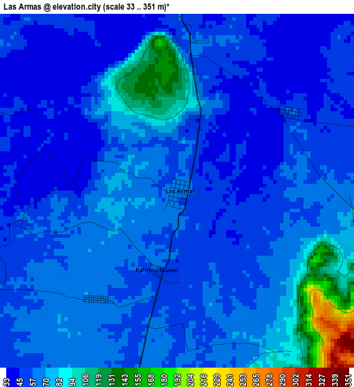
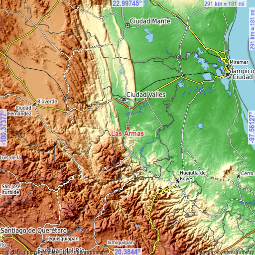
| \ | Map #1 | Topo.Map |
| Scale [m] | 33..351 m | × |
| Scale [ft] | 108..1152 ft | × |
| Average | 63.7 m = 209 ft | × |
| Width | 9.08 km = 5.6 mi | 290.5 km = 180.5 mi |
| Height | 9.08 km = 5.6 mi | 290.6 km = 180.6 mi |
| ↑Max Latitude | 21.737676° | 22.99745° |
| Latitude at center | 21.69685° | 21.69685° |
| ↓Min Latitude | 21.656012° | 20.3844° |
| ← Min Longitude | -99.011465° | -100.37377° |
| Longitude center | -98.96752° | -98.96752° |
| →Max Longitude | -98.923575° | -97.56127° |
Nearby cities:
Cities around Las Armas sort by population:
• Tampate elevation 77 m
9 km,  221°
221°
• Tancanhuitz 216 m
11 km,  180°
180°
• Aquismón 95 m
10 km,  212°
212°
• Tamcuime 96 m
11.5 km,  202°
202°
• Tampemoche 410 m
11.8 km,  266°
266°
• Tanute 67 m
8.8 km,  235°
235°
• Tandzumadz 435 m
14.7 km,  185°
185°
• Tanlajás 136 m
9.1 km,  112°
112°
• Ejido San José Xilatzén 103 m
4.8 km,  120°
120°
• Tocoy 260 m
11.9 km, 122°
• San Antonio 221 m
10.8 km,  141°
141°
• Huehuetlán 362 m
16.7 km, 180°
Multilingual:
 En español:
Las Armas elevación 66 m.
 En France:
Las Armas élévation 66 m.
 Auf Deutsch:
Las Armas höhe über dem Meeresspiegel ist 66 m.

Sources and notes:
- [note 1] Map square and city borders are not equal. Map elevation data is calculated only from area inside that square.
- [src 1] Elevation data from geonames database provided with same terms of usage.
- [src 2] The elevation map of Las Armas is generated using elevation data from NASA's 3 arcsec (90m) resolution SRTM data.
- [src 3] Base (background) map © OpenStreetMap contributors tiles are generated by Geofabrik and OpenTopoMap.
Copyright & License:
This Las Armas Elevation Map is licensed under CC BY-SA. You may reuse any part from this page, if you give a proper credit by linking to this URL:
 More info on terms of use page.