Manzana Segunda elevation
Manzana Segunda (State of Mexico, Jiquipilco), Mexico elevation is 2879 meters and Manzana Segunda elevation in feet is 9446 ft above sea level [src 1]. Manzana Segunda is a populated place (feature code) with elevation that is 1565 meters (5135 ft) bigger than average city elevation in Mexico.
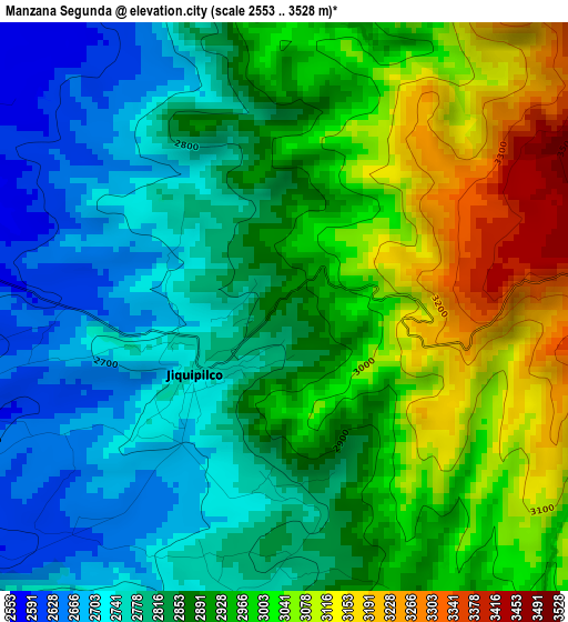
Below is the Elevation map of Manzana Segunda, which displays elevation range with different colors. Scale of the first map is from 2553 to 3528 m (8376 to 11575 ft) with average elevation of 2896 meters (=9501 ft) [note 1]
These maps also provides idea of topography and contour of this city, they are displayed at different zoom levels. More info about maps, scale and edge coordinates you can find below images.
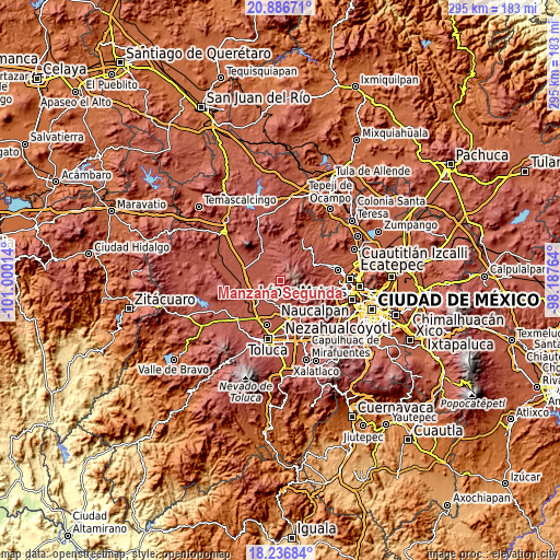
| \ | Map #1 | Topo.Map |
| Scale [m] | 2553..3528 m | × |
| Scale [ft] | 8376..11575 ft | × |
| Average | 2896 m = 9501 ft | × |
| Width | 9.21 km = 5.7 mi | 294.6 km = 183.1 mi |
| Height | 9.21 km = 5.7 mi | 294.7 km = 183.1 mi |
| ↑Max Latitude | 19.608622° | 20.88671° |
| Latitude at center | 19.56722° | 19.56722° |
| ↓Min Latitude | 19.525807° | 18.23684° |
| ← Min Longitude | -99.637835° | -101.00014° |
| Longitude center | -99.59389° | -99.59389° |
| →Max Longitude | -99.549945° | -98.18764° |
Nearby cities:
Cities around Manzana Segunda sort by population:
• San Bartolo Oxtotitlán elevation 2731 m
6.1 km,  340°
340°
• Enthavi 2803 m
7.9 km,  165°
165°
• Manzana Quinta (La Cañada) 2732 m
2.9 km,  197°
197°
• Santa María Nativitas 2789 m
2.1 km,  310°
310°
• Jiquipilco 2747 m
1.9 km,  231°
231°
• San Pedro Arriba 3ra. Sección 2934 m
8.3 km,  152°
152°
• Manzana Sexta Parte Centro 2757 m
4.6 km, 195°
• Solalpan 1ra. Sección 2835 m
8.5 km, 166°
• San José del Sitio 2545 m
8.5 km,  297°
297°
• Tierra Blanca 2880 m
6.8 km, 171°
• Tlaltenanguito 2847 m
7.8 km, 171°
• Sección del Cerrito 2593 m
8.9 km,  264°
264°
Multilingual:
 En español:
Manzana Segunda elevación 2879 m.
 En France:
Manzana Segunda élévation 2879 m.
 Auf Deutsch:
Manzana Segunda höhe über dem Meeresspiegel ist 2879 m.

Sources and notes:
- [note 1] Map square and city borders are not equal. Map elevation data is calculated only from area inside that square.
- [src 1] Elevation data from geonames database provided with same terms of usage.
- [src 2] The elevation map of Manzana Segunda is generated using elevation data from NASA's 3 arcsec (90m) resolution SRTM data.
- [src 3] Base (background) map © OpenStreetMap contributors tiles are generated by Geofabrik and OpenTopoMap.
Copyright & License:
This Manzana Segunda Elevation Map is licensed under CC BY-SA. You may reuse any part from this page, if you give a proper credit by linking to this URL:
 More info on terms of use page.