San Bartolo Oxtotitlán elevation
San Bartolo Oxtotitlán (State of Mexico, Jiquipilco), Mexico elevation is 2731 meters and San Bartolo Oxtotitlán elevation in feet is 8960 ft above sea level [src 1]. San Bartolo Oxtotitlán is a populated place (feature code) with elevation that is 1417 meters (4649 ft) bigger than average city elevation in Mexico.
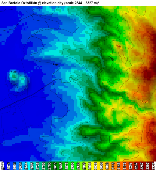
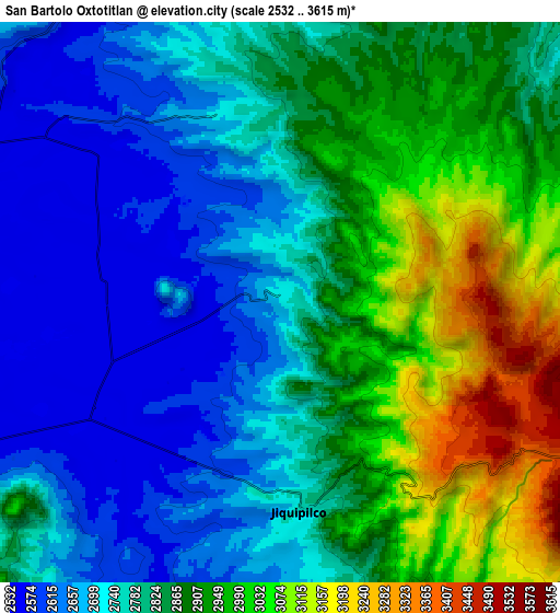
Below is the Elevation map of San Bartolo Oxtotitlán, which displays elevation range with different colors. Scale of the first map is from 2544 to 3327 m (8346 to 10915 ft) with average elevation of 2764.6 meters (=9070 ft) [note 1]
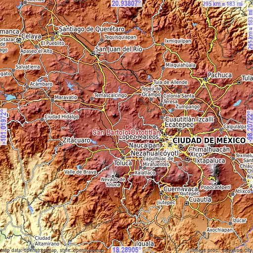
These maps also provides idea of topography and contour of this city, they are displayed at different zoom levels. More info about maps, scale and edge coordinates you can find below images.
| \ | Map #1 | Map #2 | Topo.Map |
| Scale [m] | 2544..3327 m | 2532..3615 m | × |
| Scale [ft] | 8346..10915 ft | 8307..11860 ft | × |
| Average | 2764.6 m = 9070 ft | 2823.7 m = 9264 ft | × |
| Width | 9.21 km = 5.7 mi | 18.41 km = 11.4 mi | 294.5 km = 183 mi |
| Height | 9.21 km = 5.7 mi | 18.41 km = 11.4 mi | 294.6 km = 183.1 mi |
| ↑Max Latitude | 19.660409° | 19.701787° | 20.93807° |
| Latitude at center | 19.61902° | 19.61902° | 19.61902° |
| ↓Min Latitude | 19.577621° | 19.53621° | 18.28905° |
| ← Min Longitude | -99.657415° | -99.701361° | -101.01972° |
| Longitude center | -99.61347° | -99.61347° | -99.61347° |
| →Max Longitude | -99.569525° | -99.525579° | -98.20722° |
Nearby cities:
Cities around San Bartolo Oxtotitlán sort by population:
• Pueblo Nuevo elevation 2787 m
6.1 km,  356°
356°
• San Lorenzo Malacota 2651 m
3.4 km, 359°
• Ejido Loma de Malacota 2555 m
7.4 km,  305°
305°
• Manzana Quinta (La Cañada) 2732 m
8.6 km,  172°
172°
• Santa María Nativitas 2789 m
4.4 km, 173°
• Jiquipilco 2747 m
7 km,  175°
175°
• Buenos Aires 2546 m
5.7 km,  268°
268°
• San José del Sitio 2545 m
5.8 km,  251°
251°
• Rancho Alegre 2545 m
7.4 km,  275°
275°
• San Antonio Nixini 2579 m
9.7 km, 309°
• Sección del Cerrito 2593 m
9.5 km,  225°
225°
• Manzana Segunda 2879 m
6.1 km,  160°
160°
Multilingual:
 En español:
San Bartolo Oxtotitlán elevación 2731 m.
 En France:
San Bartolo Oxtotitlán élévation 2731 m.
 Auf Deutsch:
San Bartolo Oxtotitlán höhe über dem Meeresspiegel ist 2731 m.
 На русском:
San Bartolo Oxtotitlán высота над уровнем моря 2731 м
Sources and notes:
- [note 1] Map square and city borders are not equal. Map elevation data is calculated only from area inside that square.
- [src 1] Elevation data from geonames database provided with same terms of usage.
- [src 2] The elevation map of San Bartolo Oxtotitlán is generated using elevation data from NASA's 3 arcsec (90m) resolution SRTM data.
- [src 3] Base (background) map © OpenStreetMap contributors tiles are generated by Geofabrik and OpenTopoMap.
Copyright & License:
This San Bartolo Oxtotitlán Elevation Map is licensed under CC BY-SA. You may reuse any part from this page, if you give a proper credit by linking to this URL:
 More info on terms of use page.