El Plan elevation
El Plan (State of Mexico, Almoloya de Juárez), Mexico elevation is 2631 meters and El Plan elevation in feet is 8632 ft above sea level [src 1]. El Plan is a populated place (feature code) with elevation that is 1317 meters (4321 ft) bigger than average city elevation in Mexico.
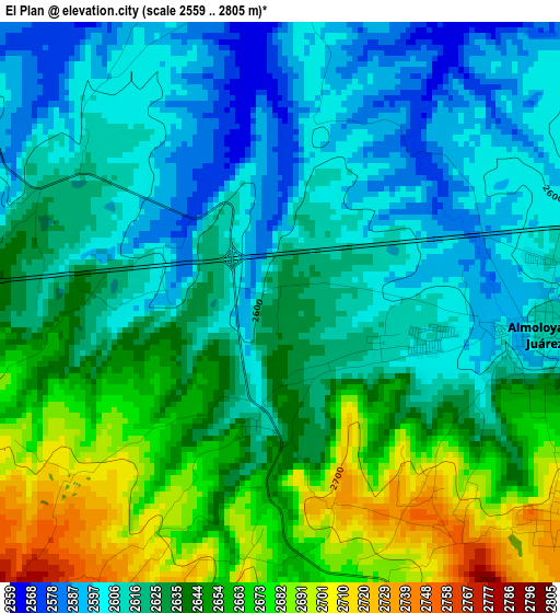
Below is the Elevation map of El Plan, which displays elevation range with different colors. Scale of the first map is from 2559 to 2805 m (8396 to 9203 ft) with average elevation of 2632 meters (=8635 ft) [note 1]
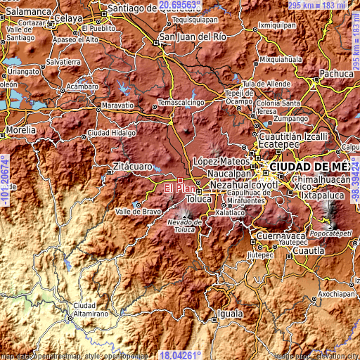
These maps also provides idea of topography and contour of this city, they are displayed at different zoom levels. More info about maps, scale and edge coordinates you can find below images.
| \ | Map #1 | Topo.Map |
| Scale [m] | 2559..2805 m | × |
| Scale [ft] | 8396..9203 ft | × |
| Average | 2632 m = 8635 ft | × |
| Width | 9.22 km = 5.7 mi | 295 km = 183.3 mi |
| Height | 9.22 km = 5.7 mi | 295 km = 183.3 mi |
| ↑Max Latitude | 19.415971° | 20.69563° |
| Latitude at center | 19.37452° | 19.37452° |
| ↓Min Latitude | 19.333058° | 18.04261° |
| ← Min Longitude | -99.844435° | -101.20674° |
| Longitude center | -99.80049° | -99.80049° |
| →Max Longitude | -99.756545° | -98.39424° |
Nearby cities:
Cities around El Plan sort by population:
• Fraccionamiento Colinas del Sol elevation 2622 m
6.3 km,  92°
92°
• La Cabecera 2632 m
5.9 km,  110°
110°
• San Mateo Tlalchichilpan 2726 m
5.7 km,  128°
128°
• San Miguel Almoloyan 2636 m
2.2 km,  176°
176°
• Villa de Almoloya de Juárez 2615 m
4.5 km,  97°
97°
• Conjunto Habitacional Ecológico SUTEYM 2606 m
2.4 km, 105°
• San Pedro de la Hortaliza (Ejido Almoloyán) 2587 m
2.4 km,  309°
309°
• Santa Juana Primera Sección 2603 m
5.4 km,  71°
71°
• Loma de San Miguel 2719 m
3.7 km,  165°
165°
• El Tepetatal 2708 m
4.5 km,  135°
135°
• Cañada de Guadarrama 2727 m
7 km, 170°
• Ejido San Diego 2579 m
5 km,  328°
328°
Multilingual:
 En español:
El Plan elevación 2631 m.
 En France:
El Plan élévation 2631 m.
 Auf Deutsch:
El Plan höhe über dem Meeresspiegel ist 2631 m.

Sources and notes:
- [note 1] Map square and city borders are not equal. Map elevation data is calculated only from area inside that square.
- [src 1] Elevation data from geonames database provided with same terms of usage.
- [src 2] The elevation map of El Plan is generated using elevation data from NASA's 3 arcsec (90m) resolution SRTM data.
- [src 3] Base (background) map © OpenStreetMap contributors tiles are generated by Geofabrik and OpenTopoMap.
Copyright & License:
This El Plan Elevation Map is licensed under CC BY-SA. You may reuse any part from this page, if you give a proper credit by linking to this URL:
 More info on terms of use page.