J. Jesús González Ortega (San Mateo) elevation
J. Jesús González Ortega (San Mateo) (Zacatecas, Valparaíso), Mexico elevation is 1998 meters and J. Jesús González Ortega (San Mateo) elevation in feet is 6555 ft above sea level [src 1]. J. Jesús González Ortega (San Mateo) is a populated place (feature code) with elevation that is 684 meters (2244 ft) bigger than average city elevation in Mexico.
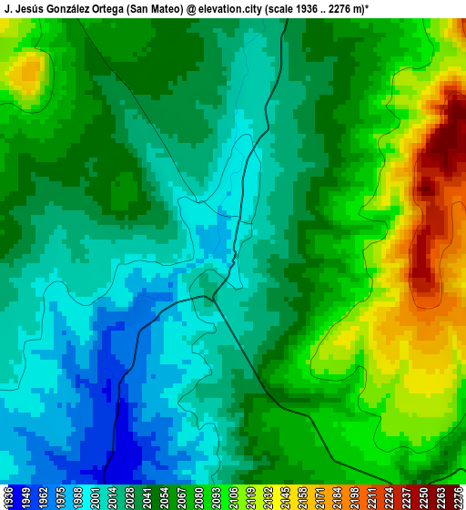
Below is the Elevation map of J. Jesús González Ortega (San Mateo), which displays elevation range with different colors. Scale of the first map is from 1936 to 2276 m (6352 to 7467 ft) with average elevation of 2052.1 meters (=6733 ft) [note 1]
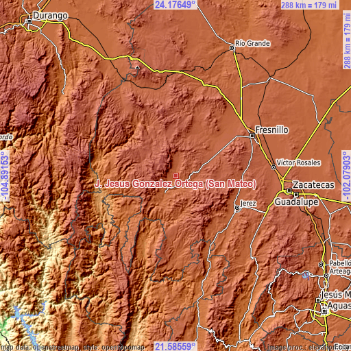
These maps also provides idea of topography and contour of this city, they are displayed at different zoom levels. More info about maps, scale and edge coordinates you can find below images.
| \ | Map #1 | Topo.Map |
| Scale [m] | 1936..2276 m | × |
| Scale [ft] | 6352..7467 ft | × |
| Average | 2052.1 m = 6733 ft | × |
| Width | 9 km = 5.6 mi | 288.1 km = 179 mi |
| Height | 9 km = 5.6 mi | 288.1 km = 179 mi |
| ↑Max Latitude | 22.9277° | 24.17649° |
| Latitude at center | 22.88722° | 22.88722° |
| ↓Min Latitude | 22.846728° | 21.58559° |
| ← Min Longitude | -103.529225° | -104.89153° |
| Longitude center | -103.48528° | -103.48528° |
| →Max Longitude | -103.441335° | -102.07903° |
Nearby cities:
Cities around J. Jesús González Ortega (San Mateo) sort by population:
• Jerez de García Salinas elevation 2001 m
57.2 km,  117°
117°
• Valparaíso 1895 m
15.6 km,  213°
213°
• Huejuquilla el Alto 1742 m
51.3 km,  235°
235°
• Ermita de Guadalupe 1962 m
57.4 km,  125°
125°
• El Salto 2079 m
54.8 km,  51°
51°
• Jiménez del Teul 1888 m
51.8 km,  321°
321°
• Tepetongo 1939 m
58.7 km,  144°
144°
• Buenavista de Trujillo 2107 m
42.4 km, 45°
• Tapias de Santa Cruz (Pedro Ruiz González) 2087 m
49.4 km, 47°
• Colonia Plenitud 2060 m
56.9 km, 47°
• Lobatos 2006 m
10.8 km, 131°
• Susticacán 2036 m
50.4 km, 127°
Multilingual:
 En español:
J. Jesús González Ortega (San Mateo) elevación 1998 m.
 En France:
J. Jesús González Ortega (San Mateo) élévation 1998 m.
 Auf Deutsch:
J. Jesús González Ortega (San Mateo) höhe über dem Meeresspiegel ist 1998 m.
 На русском:
J. Jesús González Ortega (San Mateo) высота над уровнем моря 1998 м
Sources and notes:
- [note 1] Map square and city borders are not equal. Map elevation data is calculated only from area inside that square.
- [src 1] Elevation data from geonames database provided with same terms of usage.
- [src 2] The elevation map of J. Jesús González Ortega (San Mateo) is generated using elevation data from NASA's 3 arcsec (90m) resolution SRTM data.
- [src 3] Base (background) map © OpenStreetMap contributors tiles are generated by Geofabrik and OpenTopoMap.
Copyright & License:
This J. Jesús González Ortega (San Mateo) Elevation Map is licensed under CC BY-SA. You may reuse any part from this page, if you give a proper credit by linking to this URL:
 More info on terms of use page.