Santa Cruz Otlatla elevation
Santa Cruz Otlatla (Puebla, Tlahuapan), Mexico elevation is 2857 meters and Santa Cruz Otlatla elevation in feet is 9373 ft above sea level [src 1]. Santa Cruz Otlatla is a populated place (feature code) with elevation that is 1543 meters (5062 ft) bigger than average city elevation in Mexico.
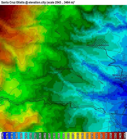
Below is the Elevation map of Santa Cruz Otlatla, which displays elevation range with different colors. Scale of the first map is from 2543 to 3464 m (8343 to 11365 ft) with average elevation of 2882.2 meters (=9456 ft) [note 1]
These maps also provides idea of topography and contour of this city, they are displayed at different zoom levels. More info about maps, scale and edge coordinates you can find below images.
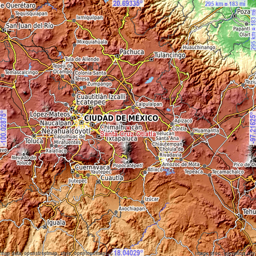
| \ | Map #1 | Topo.Map |
| Scale [m] | 2543..3464 m | × |
| Scale [ft] | 8343..11365 ft | × |
| Average | 2882.2 m = 9456 ft | × |
| Width | 9.22 km = 5.7 mi | 295 km = 183.3 mi |
| Height | 9.22 km = 5.7 mi | 295 km = 183.3 mi |
| ↑Max Latitude | 19.413672° | 20.69335° |
| Latitude at center | 19.37222° | 19.37222° |
| ↓Min Latitude | 19.330757° | 18.04029° |
| ← Min Longitude | -98.666445° | -100.02875° |
| Longitude center | -98.6225° | -98.6225° |
| →Max Longitude | -98.578555° | -97.21625° |
Nearby cities:
Cities around Santa Cruz Otlatla sort by population:
• Santa Rita Tlahuapan elevation 2599 m
6.5 km,  132°
132°
• Río Frío de Juárez 2980 m
5.5 km,  247°
247°
• San Rafael Ixtapalucan 2581 m
11.2 km,  142°
142°
• Santa María Texmelucan 2484 m
12.4 km, 134°
• San Miguel Tianguistenco 2459 m
13 km, 132°
• Santiago Coltzingo 2467 m
9.3 km,  82°
82°
• Juárez Coronaco 2430 m
10.3 km,  97°
97°
• Guadalupe Zaragoza 2459 m
9 km, 99°
• San Juan Cuauhtémoc 2767 m
3.2 km,  55°
55°
• San Felipe Hidalgo 2818 m
12.6 km,  32°
32°
• Ignacio Manuel Altamirano 2668 m
4.2 km, 97°
• San Pedro Matamoros 2542 m
7.1 km,  92°
92°
Multilingual:
 En español:
Santa Cruz Otlatla elevación 2857 m.
 En France:
Santa Cruz Otlatla élévation 2857 m.
 Auf Deutsch:
Santa Cruz Otlatla höhe über dem Meeresspiegel ist 2857 m.
 На русском:
Santa Cruz Otlatla высота над уровнем моря 2857 м
Sources and notes:
- [note 1] Map square and city borders are not equal. Map elevation data is calculated only from area inside that square.
- [src 1] Elevation data from geonames database provided with same terms of usage.
- [src 2] The elevation map of Santa Cruz Otlatla is generated using elevation data from NASA's 3 arcsec (90m) resolution SRTM data.
- [src 3] Base (background) map © OpenStreetMap contributors tiles are generated by Geofabrik and OpenTopoMap.
Copyright & License:
This Santa Cruz Otlatla Elevation Map is licensed under CC BY-SA. You may reuse any part from this page, if you give a proper credit by linking to this URL:
 More info on terms of use page.