San Felipe Hidalgo elevation
San Felipe Hidalgo (Puebla), Mexico elevation is 2818 meters and San Felipe Hidalgo elevation in feet is 9245 ft above sea level [src 1]. San Felipe Hidalgo is a populated place (feature code) with elevation that is 1504 meters (4934 ft) bigger than average city elevation in Mexico.
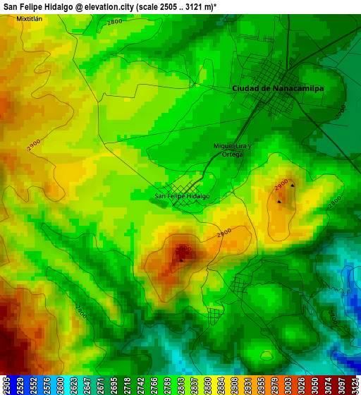
Below is the Elevation map of San Felipe Hidalgo, which displays elevation range with different colors. Scale of the first map is from 2505 to 3121 m (8219 to 10240 ft) with average elevation of 2802.4 meters (=9194 ft) [note 1]
These maps also provides idea of topography and contour of this city, they are displayed at different zoom levels. More info about maps, scale and edge coordinates you can find below images.

| \ | Map #1 | Topo.Map |
| Scale [m] | 2505..3121 m | × |
| Scale [ft] | 8219..10240 ft | × |
| Average | 2802.4 m = 9194 ft | × |
| Width | 9.21 km = 5.7 mi | 294.8 km = 183.2 mi |
| Height | 9.21 km = 5.7 mi | 294.8 km = 183.2 mi |
| ↑Max Latitude | 19.509348° | 20.78825° |
| Latitude at center | 19.46792° | 19.46792° |
| ↓Min Latitude | 19.426482° | 18.13675° |
| ← Min Longitude | -98.602925° | -99.96523° |
| Longitude center | -98.55898° | -98.55898° |
| →Max Longitude | -98.515035° | -97.15273° |
Nearby cities:
Cities around San Felipe Hidalgo sort by population:
• Ciudad de Nanacamilpa elevation 2745 m
3.7 km,  39°
39°
• Sanctórum 2742 m
9.6 km,  72°
72°
• Santiago Coltzingo 2467 m
9.8 km,  164°
164°
• Juárez Coronaco 2430 m
12.5 km, 163°
• Guadalupe Zaragoza 2459 m
12.4 km,  169°
169°
• Mazapa 2716 m
8.1 km,  1°
1°
• San Juan Cuauhtémoc 2767 m
9.7 km,  204°
204°
• Ignacio Manuel Altamirano 2668 m
11.5 km,  192°
192°
• San Pedro Matamoros 2542 m
10.9 km,  177°
177°
• Francisco I. Madero 2634 m
9.3 km,  50°
50°
• Santa Cruz Otlatla 2857 m
12.6 km,  212°
212°
• La Soledad 2746 m
10 km,  321°
321°
Multilingual:
 En español:
San Felipe Hidalgo elevación 2818 m.
 En France:
San Felipe Hidalgo élévation 2818 m.
 Auf Deutsch:
San Felipe Hidalgo höhe über dem Meeresspiegel ist 2818 m.
 На русском:
San Felipe Hidalgo высота над уровнем моря 2818 м
Sources and notes:
- [note 1] Map square and city borders are not equal. Map elevation data is calculated only from area inside that square.
- [src 1] Elevation data from geonames database provided with same terms of usage.
- [src 2] The elevation map of San Felipe Hidalgo is generated using elevation data from NASA's 3 arcsec (90m) resolution SRTM data.
- [src 3] Base (background) map © OpenStreetMap contributors tiles are generated by Geofabrik and OpenTopoMap.
Copyright & License:
This San Felipe Hidalgo Elevation Map is licensed under CC BY-SA. You may reuse any part from this page, if you give a proper credit by linking to this URL:
 More info on terms of use page.