Loma Bonita elevation
Loma Bonita (State of Mexico, Ocoyoacac), Mexico elevation is 2617 meters and Loma Bonita elevation in feet is 8586 ft above sea level [src 1]. Loma Bonita is a populated place (feature code) with elevation that is 1303 meters (4275 ft) bigger than average city elevation in Mexico.
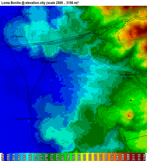
Below is the Elevation map of Loma Bonita, which displays elevation range with different colors. Scale of the first map is from 2569 to 3156 m (8428 to 10354 ft) with average elevation of 2700.9 meters (=8861 ft) [note 1]
These maps also provides idea of topography and contour of this city, they are displayed at different zoom levels. More info about maps, scale and edge coordinates you can find below images.
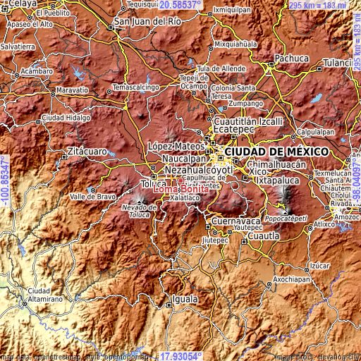
| \ | Map #1 | Topo.Map |
| Scale [m] | 2569..3156 m | × |
| Scale [ft] | 8428..10354 ft | × |
| Average | 2700.9 m = 8861 ft | × |
| Width | 9.23 km = 5.7 mi | 295.2 km = 183.4 mi |
| Height | 9.23 km = 5.7 mi | 295.2 km = 183.4 mi |
| ↑Max Latitude | 19.30481° | 20.58537° |
| Latitude at center | 19.26333° | 19.26333° |
| ↓Min Latitude | 19.22184° | 17.93054° |
| ← Min Longitude | -99.491165° | -100.85347° |
| Longitude center | -99.44722° | -99.44722° |
| →Max Longitude | -99.403275° | -98.04097° |
Nearby cities:
Cities around Loma Bonita sort by population:
• Ocoyoacac elevation 2597 m
1.4 km,  308°
308°
• San Pedro Cholula 2577 m
4.1 km,  271°
271°
• San Pedro Chochula 2577 m
4.1 km, 270°
• San Miguel Ameyalco 2587 m
5 km,  345°
345°
• San Jerónimo Acazulco 2754 m
3.3 km,  85°
85°
• San Nicolás Tlazala 2591 m
4.5 km,  202°
202°
• El Pedregal de Guadalupe Hidalgo 2593 m
2.2 km,  237°
237°
• Fraccionamiento y Club de Golf los Encinos 2642 m
4.5 km, 309°
• Colonia Juárez 2682 m
3.2 km,  320°
320°
• El Llano del Compromiso 2576 m
3.5 km,  254°
254°
• Colonia el Pirame 2586 m
3.6 km,  226°
226°
• Agua Blanca 2575 m
5.3 km,  207°
207°
Multilingual:
 En español:
Loma Bonita elevación 2617 m.
 En France:
Loma Bonita élévation 2617 m.
 Auf Deutsch:
Loma Bonita höhe über dem Meeresspiegel ist 2617 m.

Sources and notes:
- [note 1] Map square and city borders are not equal. Map elevation data is calculated only from area inside that square.
- [src 1] Elevation data from geonames database provided with same terms of usage.
- [src 2] The elevation map of Loma Bonita is generated using elevation data from NASA's 3 arcsec (90m) resolution SRTM data.
- [src 3] Base (background) map © OpenStreetMap contributors tiles are generated by Geofabrik and OpenTopoMap.
Copyright & License:
This Loma Bonita Elevation Map is licensed under CC BY-SA. You may reuse any part from this page, if you give a proper credit by linking to this URL:
 More info on terms of use page.