San Pedro Chochula elevation
San Pedro Chochula (Morelos), Mexico elevation is 2577 meters and San Pedro Chochula elevation in feet is 8455 ft above sea level [src 1]. San Pedro Chochula is a populated place (feature code) with elevation that is 1263 meters (4144 ft) bigger than average city elevation in Mexico.
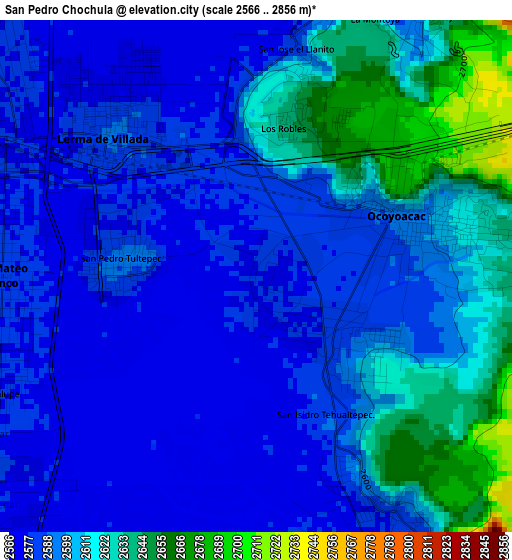
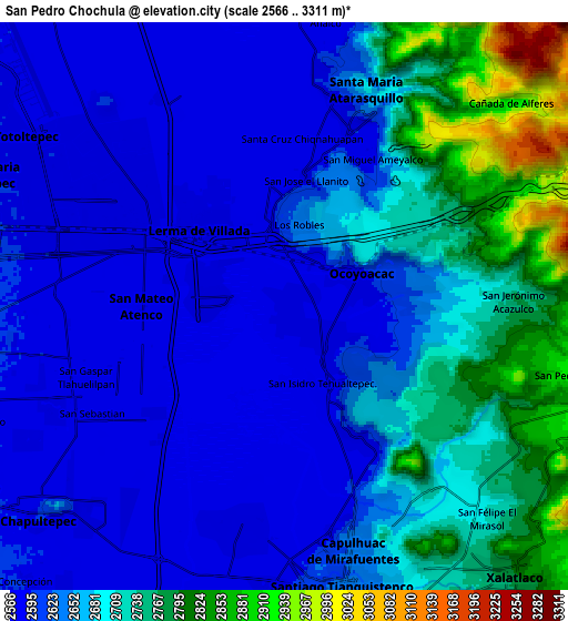
Below is the Elevation map of San Pedro Chochula, which displays elevation range with different colors. Scale of the first map is from 2566 to 2856 m (8419 to 9370 ft) with average elevation of 2600.2 meters (=8531 ft) [note 1]
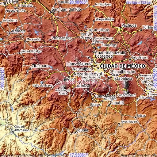
These maps also provides idea of topography and contour of this city, they are displayed at different zoom levels. More info about maps, scale and edge coordinates you can find below images.
| \ | Map #1 | Map #2 | Topo.Map |
| Scale [m] | 2566..2856 m | 2566..3311 m | × |
| Scale [ft] | 8419..9370 ft | 8419..10863 ft | × |
| Average | 2600.2 m = 8531 ft | 2664 m = 8740 ft | × |
| Width | 9.23 km = 5.7 mi | 18.45 km = 11.5 mi | 295.2 km = 183.4 mi |
| Height | 9.23 km = 5.7 mi | 18.45 km = 11.5 mi | 295.2 km = 183.4 mi |
| ↑Max Latitude | 19.30507° | 19.346539° | 20.58563° |
| Latitude at center | 19.26359° | 19.26359° | 19.26359° |
| ↓Min Latitude | 19.2221° | 19.180599° | 17.93081° |
| ← Min Longitude | -99.529845° | -99.573791° | -100.89215° |
| Longitude center | -99.4859° | -99.4859° | -99.4859° |
| →Max Longitude | -99.441955° | -99.398009° | -98.07965° |
Nearby cities:
Cities around San Pedro Chochula sort by population:
• Ocoyoacac elevation 2597 m
3.1 km,  73°
73°
• Lerma de Villada 2587 m
3.9 km,  316°
316°
• San Pedro Tultepec 2592 m
2.5 km,  274°
274°
• San Pedro Cholula 2577 m
0.1 km,  331°
331°
• El Pedregal de Guadalupe Hidalgo 2593 m
2.5 km,  118°
118°
• Fraccionamiento y Club de Golf los Encinos 2642 m
2.9 km,  12°
12°
• Colonia Juárez 2682 m
3.2 km,  39°
39°
• El Llano del Compromiso 2576 m
1.2 km,  144°
144°
• Loma Bonita 2617 m
4.1 km,  90°
90°
• Colonia el Pirame 2586 m
2.9 km,  149°
149°
• San Antonio el Llanito 2574 m
1.8 km, 328°
• Nueva Ameyalco 2575 m
4.3 km, 332°
Multilingual:
 En español:
San Pedro Chochula elevación 2577 m.
 En France:
San Pedro Chochula élévation 2577 m.
 Auf Deutsch:
San Pedro Chochula höhe über dem Meeresspiegel ist 2577 m.
 На русском:
San Pedro Chochula высота над уровнем моря 2577 м
Sources and notes:
- [note 1] Map square and city borders are not equal. Map elevation data is calculated only from area inside that square.
- [src 1] Elevation data from geonames database provided with same terms of usage.
- [src 2] The elevation map of San Pedro Chochula is generated using elevation data from NASA's 3 arcsec (90m) resolution SRTM data.
- [src 3] Base (background) map © OpenStreetMap contributors tiles are generated by Geofabrik and OpenTopoMap.
Copyright & License:
This San Pedro Chochula Elevation Map is licensed under CC BY-SA. You may reuse any part from this page, if you give a proper credit by linking to this URL:
 More info on terms of use page.