Zoyatitla elevation
Zoyatitla (Puebla, Tetela de Ocampo), Mexico elevation is 1724 meters and Zoyatitla elevation in feet is 5656 ft above sea level [src 1]. Zoyatitla is a populated place (feature code) with elevation that is 410 meters (1345 ft) bigger than average city elevation in Mexico.
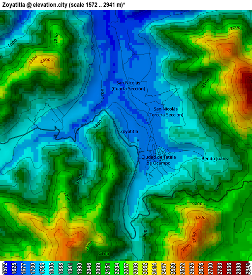
Below is the Elevation map of Zoyatitla, which displays elevation range with different colors. Scale of the first map is from 1572 to 2941 m (5157 to 9649 ft) with average elevation of 2000.7 meters (=6564 ft) [note 1]
These maps also provides idea of topography and contour of this city, they are displayed at different zoom levels. More info about maps, scale and edge coordinates you can find below images.
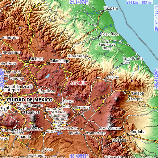
| \ | Map #1 | Topo.Map |
| Scale [m] | 1572..2941 m | × |
| Scale [ft] | 5157..9649 ft | × |
| Average | 2000.7 m = 6564 ft | × |
| Width | 9.19 km = 5.7 mi | 294.2 km = 182.8 mi |
| Height | 9.19 km = 5.7 mi | 294.2 km = 182.8 mi |
| ↑Max Latitude | 19.864766° | 21.14074° |
| Latitude at center | 19.82343° | 19.82343° |
| ↓Min Latitude | 19.782083° | 18.49511° |
| ← Min Longitude | -97.862255° | -99.22456° |
| Longitude center | -97.81831° | -97.81831° |
| →Max Longitude | -97.774365° | -96.41206° |
Nearby cities:
Cities around Zoyatitla sort by population:
• Tetela de Ocampo elevation 1736 m
1.4 km,  118°
118°
• Tlamanca de Hernández 1413 m
14.7 km,  1°
1°
• Xochitlaxco (San Baltazar) 1951 m
13.9 km,  340°
340°
• Benito Juárez 1802 m
2.9 km,  105°
105°
• Tonalixco 1654 m
17.7 km,  352°
352°
• San Miguel Tenango 2062 m
15.4 km,  307°
307°
• Tepetzintla 1688 m
16.2 km, 351°
• Cuautempan 1513 m
10.3 km,  13°
13°
• Zoyotla 1149 m
17.4 km,  48°
48°
• Xochiapulco 2052 m
16.6 km,  90°
90°
• Ixtolco de Morelos 1559 m
9.1 km, 0°
• Aquixtla 2198 m
12.6 km,  255°
255°
Multilingual:
 En español:
Zoyatitla elevación 1724 m.
 En France:
Zoyatitla élévation 1724 m.
 Auf Deutsch:
Zoyatitla höhe über dem Meeresspiegel ist 1724 m.

Sources and notes:
- [note 1] Map square and city borders are not equal. Map elevation data is calculated only from area inside that square.
- [src 1] Elevation data from geonames database provided with same terms of usage.
- [src 2] The elevation map of Zoyatitla is generated using elevation data from NASA's 3 arcsec (90m) resolution SRTM data.
- [src 3] Base (background) map © OpenStreetMap contributors tiles are generated by Geofabrik and OpenTopoMap.
Copyright & License:
This Zoyatitla Elevation Map is licensed under CC BY-SA. You may reuse any part from this page, if you give a proper credit by linking to this URL:
 More info on terms of use page.