Lomas de San Martín elevation
Lomas de San Martín (Nuevo León, Pesquería), Mexico elevation is 385 meters and Lomas de San Martín elevation in feet is 1263 ft above sea level [src 1]. Lomas de San Martín is a populated place (feature code) with elevation that is 929 meters (3048 ft) smaller than average city elevation in Mexico.
Below is the Elevation map of Lomas de San Martín, which displays elevation range with different colors. Scale of the first map is from 349 to 436 m (1145 to 1430 ft) with average elevation of 388.8 meters (=1276 ft) [note 1]
These maps also provides idea of topography and contour of this city, they are displayed at different zoom levels. More info about maps, scale and edge coordinates you can find below images.
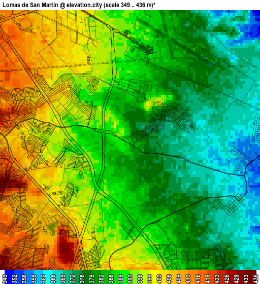
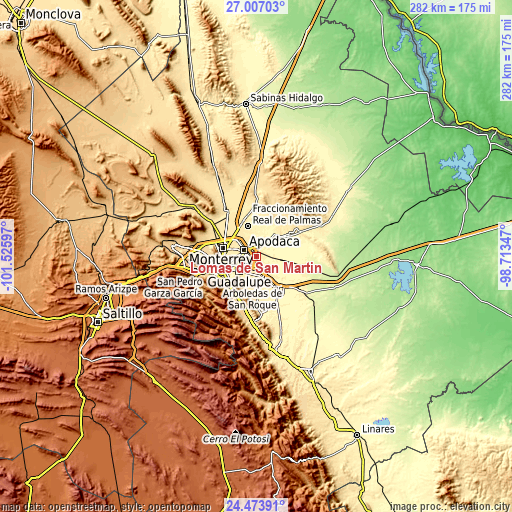
| \ | Map #1 | Topo.Map |
| Scale [m] | 349..436 m | × |
| Scale [ft] | 1145..1430 ft | × |
| Average | 388.8 m = 1276 ft | × |
| Width | 8.8 km = 5.5 mi | 281.7 km = 175 mi |
| Height | 8.8 km = 5.5 mi | 281.7 km = 175 mi |
| ↑Max Latitude | 25.786796° | 27.00703° |
| Latitude at center | 25.74722° | 25.74722° |
| ↓Min Latitude | 25.707631° | 24.47391° |
| ← Min Longitude | -100.163665° | -101.52597° |
| Longitude center | -100.11972° | -100.11972° |
| →Max Longitude | -100.075775° | -98.71347° |
Nearby cities:
Cities around Lomas de San Martín sort by population:
• Ciudad Apodaca elevation 431 m
7.9 km,  299°
299°
• Ciudad Benito Juárez 388 m
11.4 km,  167°
167°
• Prados de Santa Rosa 440 m
12.1 km, 297°
• Misión San Pablo 399 m
2.6 km,  251°
251°
• Héctor Caballero 429 m
12.4 km,  183°
183°
• Loma la Paz 402 m
4.3 km,  200°
200°
• Pesquería 334 m
8.1 km,  58°
58°
• Colinas del Aeropuerto 383 m
8 km,  12°
12°
• Fraccionamiento Misión de San Javier 405 m
3.2 km,  266°
266°
• Ladrillera (Entronque Pesquería) 367 m
6.5 km,  16°
16°
• Artemio Treviño 401 m
10.1 km,  346°
346°
• Paseo de San Javier 394 m
1.7 km,  240°
240°
Multilingual:
 En español:
Lomas de San Martín elevación 385 m.
 En France:
Lomas de San Martín élévation 385 m.
 Auf Deutsch:
Lomas de San Martín höhe über dem Meeresspiegel ist 385 m.
 На русском:
Lomas de San Martín высота над уровнем моря 385 м
Sources and notes:
- [note 1] Map square and city borders are not equal. Map elevation data is calculated only from area inside that square.
- [src 1] Elevation data from geonames database provided with same terms of usage.
- [src 2] The elevation map of Lomas de San Martín is generated using elevation data from NASA's 3 arcsec (90m) resolution SRTM data.
- [src 3] Base (background) map © OpenStreetMap contributors tiles are generated by Geofabrik and OpenTopoMap.
Copyright & License:
This Lomas de San Martín Elevation Map is licensed under CC BY-SA. You may reuse any part from this page, if you give a proper credit by linking to this URL:
 More info on terms of use page.