Lomas de Tepemecatl elevation
Lomas de Tepemecatl (Mexico City, Tlalpan), Mexico elevation is 2955 meters and Lomas de Tepemecatl elevation in feet is 9695 ft above sea level [src 1]. Lomas de Tepemecatl is a populated place (feature code) with elevation that is 1641 meters (5384 ft) bigger than average city elevation in Mexico.
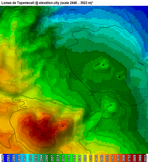
Below is the Elevation map of Lomas de Tepemecatl, which displays elevation range with different colors. Scale of the first map is from 2446 to 3923 m (8025 to 12871 ft) with average elevation of 3067.8 meters (=10065 ft) [note 1]
These maps also provides idea of topography and contour of this city, they are displayed at different zoom levels. More info about maps, scale and edge coordinates you can find below images.
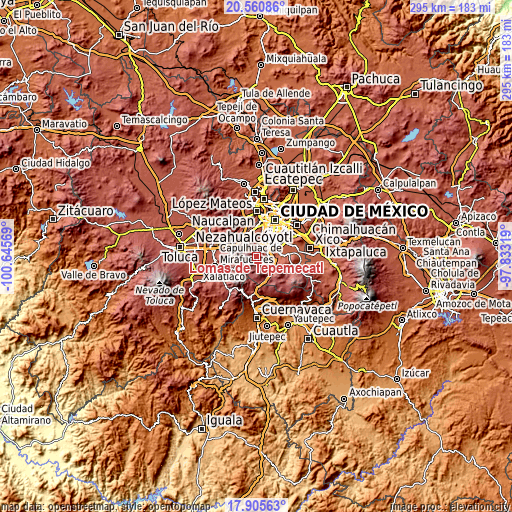
| \ | Map #1 | Topo.Map |
| Scale [m] | 2446..3923 m | × |
| Scale [ft] | 8025..12871 ft | × |
| Average | 3067.8 m = 10065 ft | × |
| Width | 9.23 km = 5.7 mi | 295.2 km = 183.4 mi |
| Height | 9.23 km = 5.7 mi | 295.3 km = 183.5 mi |
| ↑Max Latitude | 19.280096° | 20.56086° |
| Latitude at center | 19.23861° | 19.23861° |
| ↓Min Latitude | 19.197114° | 17.90563° |
| ← Min Longitude | -99.283385° | -100.64569° |
| Longitude center | -99.23944° | -99.23944° |
| →Max Longitude | -99.195495° | -97.83319° |
Nearby cities:
Cities around Lomas de Tepemecatl sort by population:
• Álvaro Obregón elevation 2338 m
13.9 km,  15°
15°
• Coyoacán 2255 m
14.5 km,  34°
34°
• Tlalpan 2256 m
10.3 km,  52°
52°
• Xochimilco 2244 m
14.4 km,  82°
82°
• Magdalena Contreras 2348 m
10.8 km, 15°
• Delegación Cuajimalpa de Morelos 2655 m
15.5 km,  339°
339°
• San Miguel Topilejo 2652 m
11 km,  111°
111°
• San Miguel Ajusco 2896 m
4.3 km,  115°
115°
• San Lorenzo Acopilco 2935 m
13.7 km,  317°
317°
• Col. Bosques de las Lomas 2570 m
15.8 km,  349°
349°
• Zacamulpa 2773 m
16.2 km, 323°
• San Juan Yautepec 2822 m
16.2 km, 319°
Multilingual:
 En español:
Lomas de Tepemecatl elevación 2955 m.
 En France:
Lomas de Tepemecatl élévation 2955 m.
 Auf Deutsch:
Lomas de Tepemecatl höhe über dem Meeresspiegel ist 2955 m.
 На русском:
Lomas de Tepemecatl высота над уровнем моря 2955 м
Sources and notes:
- [note 1] Map square and city borders are not equal. Map elevation data is calculated only from area inside that square.
- [src 1] Elevation data from geonames database provided with same terms of usage.
- [src 2] The elevation map of Lomas de Tepemecatl is generated using elevation data from NASA's 3 arcsec (90m) resolution SRTM data.
- [src 3] Base (background) map © OpenStreetMap contributors tiles are generated by Geofabrik and OpenTopoMap.
Copyright & License:
This Lomas de Tepemecatl Elevation Map is licensed under CC BY-SA. You may reuse any part from this page, if you give a proper credit by linking to this URL:
 More info on terms of use page.