Veintiuno de Agosto elevation
Veintiuno de Agosto (Veracruz, Altotonga), Mexico elevation is 2179 meters and Veintiuno de Agosto elevation in feet is 7149 ft above sea level [src 1]. Veintiuno de Agosto is a populated place (feature code) with elevation that is 865 meters (2838 ft) bigger than average city elevation in Mexico.
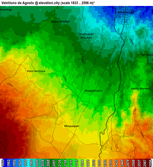
Below is the Elevation map of Veintiuno de Agosto, which displays elevation range with different colors. Scale of the first map is from 1833 to 2596 m (6014 to 8517 ft) with average elevation of 2208.1 meters (=7244 ft) [note 1]
These maps also provides idea of topography and contour of this city, they are displayed at different zoom levels. More info about maps, scale and edge coordinates you can find below images.
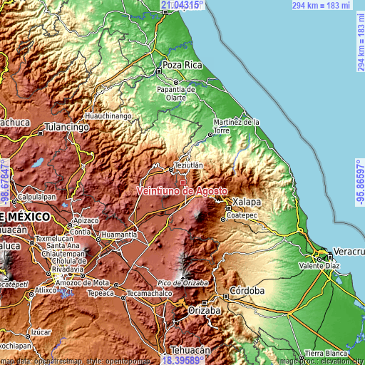
| \ | Map #1 | Topo.Map |
| Scale [m] | 1833..2596 m | × |
| Scale [ft] | 6014..8517 ft | × |
| Average | 2208.1 m = 7244 ft | × |
| Width | 9.2 km = 5.7 mi | 294.3 km = 182.9 mi |
| Height | 9.2 km = 5.7 mi | 294.4 km = 182.9 mi |
| ↑Max Latitude | 19.766361° | 21.04315° |
| Latitude at center | 19.725° | 19.725° |
| ↓Min Latitude | 19.683628° | 18.39589° |
| ← Min Longitude | -97.316165° | -98.67847° |
| Longitude center | -97.27222° | -97.27222° |
| →Max Longitude | -97.228275° | -95.86597° |
Nearby cities:
Cities around Veintiuno de Agosto sort by population:
• Altotonga elevation 1895 m
5.4 km,  31°
31°
• Ahueyahualco 2163 m
1.4 km,  114°
114°
• Mixquiapan 2302 m
2.7 km,  193°
193°
• Ignacio Zaragoza 2165 m
5.1 km, 106°
• San Miguel Tlalpoalán 2072 m
5 km,  70°
70°
• Gutiérrez Zamora 2146 m
6 km,  90°
90°
• Ahuacatán 1958 m
7 km,  337°
337°
• Adolfo Moreno 2146 m
3.6 km, 90°
• Cuauhtamingo 2047 m
6.2 km,  315°
315°
• Tomaquilapa 2094 m
6.2 km,  303°
303°
• Miguel Hidalgo 2072 m
3.8 km, 344°
• Xoampolco 1816 m
6 km,  48°
48°
Multilingual:
 En español:
Veintiuno de Agosto elevación 2179 m.
 En France:
Veintiuno de Agosto élévation 2179 m.
 Auf Deutsch:
Veintiuno de Agosto höhe über dem Meeresspiegel ist 2179 m.
 На русском:
Veintiuno de Agosto высота над уровнем моря 2179 м
Sources and notes:
- [note 1] Map square and city borders are not equal. Map elevation data is calculated only from area inside that square.
- [src 1] Elevation data from geonames database provided with same terms of usage.
- [src 2] The elevation map of Veintiuno de Agosto is generated using elevation data from NASA's 3 arcsec (90m) resolution SRTM data.
- [src 3] Base (background) map © OpenStreetMap contributors tiles are generated by Geofabrik and OpenTopoMap.
Copyright & License:
This Veintiuno de Agosto Elevation Map is licensed under CC BY-SA. You may reuse any part from this page, if you give a proper credit by linking to this URL:
 More info on terms of use page.