Altotonga elevation
Altotonga (Veracruz), Mexico elevation is 1895 meters and Altotonga elevation in feet is 6217 ft above sea level [src 1]. Altotonga is a seat of a second-order administrative division (feature code) with elevation that is 581 meters (1906 ft) bigger than average city elevation in Mexico.
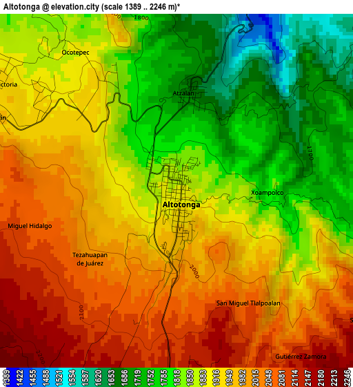
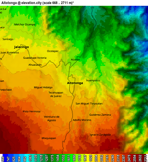
Below is the Elevation map of Altotonga, which displays elevation range with different colors. Scale of the first map is from 1389 to 2246 m (4557 to 7369 ft) with average elevation of 1904.9 meters (=6250 ft) [note 1]
These maps also provides idea of topography and contour of this city, they are displayed at different zoom levels. More info about maps, scale and edge coordinates you can find below images.
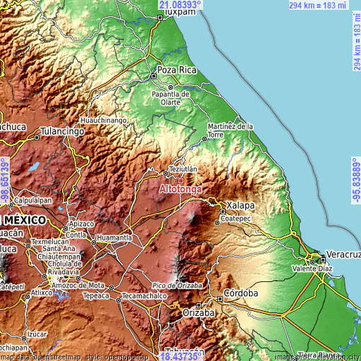
| \ | Map #1 | Map #2 | Topo.Map |
| Scale [m] | 1389..2246 m | 668..2711 m | × |
| Scale [ft] | 4557..7369 ft | 2192..8894 ft | × |
| Average | 1904.9 m = 6250 ft | 1869.9 m = 6135 ft | × |
| Width | 9.2 km = 5.7 mi | 18.39 km = 11.4 mi | 294.3 km = 182.9 mi |
| Height | 9.2 km = 5.7 mi | 18.39 km = 11.4 mi | 294.3 km = 182.9 mi |
| ↑Max Latitude | 19.807481° | 19.848821° | 21.08393° |
| Latitude at center | 19.76613° | 19.76613° | 19.76613° |
| ↓Min Latitude | 19.724769° | 19.683396° | 18.43735° |
| ← Min Longitude | -97.289085° | -97.333031° | -98.65139° |
| Longitude center | -97.24514° | -97.24514° | -97.24514° |
| →Max Longitude | -97.201195° | -97.157249° | -95.83889° |
Nearby cities:
Cities around Altotonga sort by population:
• Juan Marcos (San José Buenavista) elevation 2196 m
6.5 km,  129°
129°
• Ahueyahualco 2163 m
5.4 km,  196°
196°
• Ocotepec 1853 m
5.5 km,  326°
326°
• Ignacio Zaragoza 2165 m
6.4 km,  160°
160°
• San Miguel Tlalpoalán 2072 m
3.5 km,  146°
146°
• Atzalan 1678 m
2.5 km,  7°
7°
• Gutiérrez Zamora 2146 m
5.6 km, 145°
• Ahuacatán 1958 m
5.8 km,  289°
289°
• Adolfo Moreno 2146 m
4.7 km,  170°
170°
• Veintiuno de Agosto 2179 m
5.4 km,  211°
211°
• Miguel Hidalgo 2072 m
4 km,  256°
256°
• Xoampolco 1816 m
1.7 km,  110°
110°
Multilingual:
 En español:
Altotonga elevación 1895 m.
 En France:
Altotonga élévation 1895 m.
 Auf Deutsch:
Altotonga höhe über dem Meeresspiegel ist 1895 m.

Sources and notes:
- [note 1] Map square and city borders are not equal. Map elevation data is calculated only from area inside that square.
- [src 1] Elevation data from geonames database provided with same terms of usage.
- [src 2] The elevation map of Altotonga is generated using elevation data from NASA's 3 arcsec (90m) resolution SRTM data.
- [src 3] Base (background) map © OpenStreetMap contributors tiles are generated by Geofabrik and OpenTopoMap.
Copyright & License:
This Altotonga Elevation Map is licensed under CC BY-SA. You may reuse any part from this page, if you give a proper credit by linking to this URL:
 More info on terms of use page.