Santa Teresita de Don Diego elevation
Santa Teresita de Don Diego (Guanajuato, San Miguel de Allende), Mexico elevation is 1896 meters and Santa Teresita de Don Diego elevation in feet is 6220 ft above sea level [src 1]. Santa Teresita de Don Diego is a populated place (feature code) with elevation that is 582 meters (1909 ft) bigger than average city elevation in Mexico.
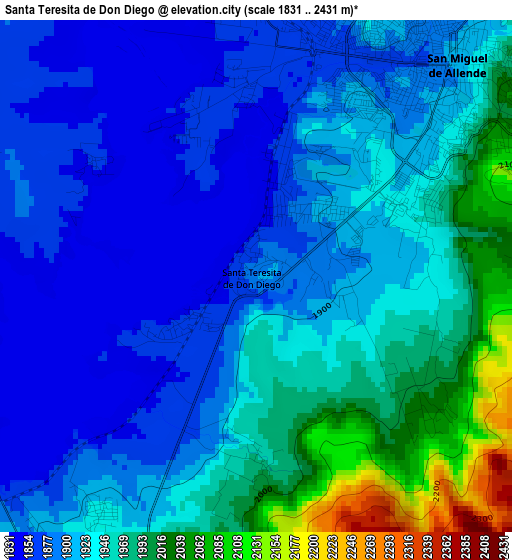
Below is the Elevation map of Santa Teresita de Don Diego, which displays elevation range with different colors. Scale of the first map is from 1831 to 2431 m (6007 to 7976 ft) with average elevation of 1927.2 meters (=6323 ft) [note 1]
These maps also provides idea of topography and contour of this city, they are displayed at different zoom levels. More info about maps, scale and edge coordinates you can find below images.
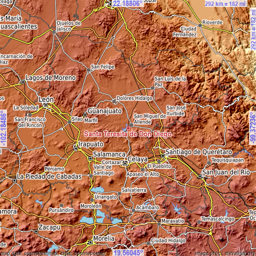
| \ | Map #1 | Topo.Map |
| Scale [m] | 1831..2431 m | × |
| Scale [ft] | 6007..7976 ft | × |
| Average | 1927.2 m = 6323 ft | × |
| Width | 9.13 km = 5.7 mi | 292.2 km = 181.6 mi |
| Height | 9.13 km = 5.7 mi | 292.2 km = 181.6 mi |
| ↑Max Latitude | 20.921054° | 22.18806° |
| Latitude at center | 20.88° | 20.88° |
| ↓Min Latitude | 20.838935° | 19.56045° |
| ← Min Longitude | -100.822555° | -102.18486° |
| Longitude center | -100.77861° | -100.77861° |
| →Max Longitude | -100.734665° | -99.37236° |
Nearby cities:
Cities around Santa Teresita de Don Diego sort by population:
• San Miguel de Allende elevation 1917 m
5.3 km,  42°
42°
• Colonia San Luis Rey 1936 m
7.6 km, 35°
• Orduña de Abajo 1803 m
13.6 km,  181°
181°
• Morales 1832 m
11.8 km,  195°
195°
• La Cieneguita 1857 m
7.5 km,  351°
351°
• Orduña de Arriba 1809 m
12.8 km,  186°
186°
• Alcocer 2124 m
7.8 km,  99°
99°
• Palo Colorado 2005 m
15.2 km,  19°
19°
• Nigromante 1891 m
9.1 km,  358°
358°
• Corralejo de Arriba 2059 m
13 km,  81°
81°
• Don Francisco 1918 m
14.8 km,  279°
279°
• La Cruz del Palmar 1866 m
12 km,  325°
325°
Multilingual:
 En español:
Santa Teresita de Don Diego elevación 1896 m.
 En France:
Santa Teresita de Don Diego élévation 1896 m.
 Auf Deutsch:
Santa Teresita de Don Diego höhe über dem Meeresspiegel ist 1896 m.
 На русском:
Santa Teresita de Don Diego высота над уровнем моря 1896 м
Sources and notes:
- [note 1] Map square and city borders are not equal. Map elevation data is calculated only from area inside that square.
- [src 1] Elevation data from geonames database provided with same terms of usage.
- [src 2] The elevation map of Santa Teresita de Don Diego is generated using elevation data from NASA's 3 arcsec (90m) resolution SRTM data.
- [src 3] Base (background) map © OpenStreetMap contributors tiles are generated by Geofabrik and OpenTopoMap.
Copyright & License:
This Santa Teresita de Don Diego Elevation Map is licensed under CC BY-SA. You may reuse any part from this page, if you give a proper credit by linking to this URL:
 More info on terms of use page.