Alcocer elevation
Alcocer (Guanajuato, San Miguel de Allende), Mexico elevation is 2124 meters and Alcocer elevation in feet is 6969 ft above sea level [src 1]. Alcocer is a populated place (feature code) with elevation that is 810 meters (2657 ft) bigger than average city elevation in Mexico.
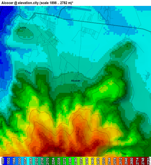
Below is the Elevation map of Alcocer, which displays elevation range with different colors. Scale of the first map is from 1898 to 2782 m (6227 to 9127 ft) with average elevation of 2198.8 meters (=7214 ft) [note 1]
These maps also provides idea of topography and contour of this city, they are displayed at different zoom levels. More info about maps, scale and edge coordinates you can find below images.
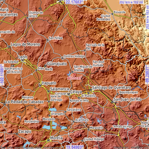
| \ | Map #1 | Topo.Map |
| Scale [m] | 1898..2782 m | × |
| Scale [ft] | 6227..9127 ft | × |
| Average | 2198.8 m = 7214 ft | × |
| Width | 9.13 km = 5.7 mi | 292.2 km = 181.6 mi |
| Height | 9.13 km = 5.7 mi | 292.2 km = 181.6 mi |
| ↑Max Latitude | 20.909727° | 22.17683° |
| Latitude at center | 20.86867° | 20.86867° |
| ↓Min Latitude | 20.827602° | 19.54903° |
| ← Min Longitude | -100.748505° | -102.11081° |
| Longitude center | -100.70456° | -100.70456° |
| →Max Longitude | -100.660615° | -99.29831° |
Nearby cities:
Cities around Alcocer sort by population:
• San Miguel de Allende elevation 1917 m
6.6 km,  321°
321°
• Colonia San Luis Rey 1936 m
8.1 km,  336°
336°
• Jalpilla 1823 m
15.4 km,  186°
186°
• Orduña de Abajo 1803 m
14.7 km,  213°
213°
• Morales 1832 m
14.8 km,  227°
227°
• Santa Teresita de Don Diego 1896 m
7.8 km,  279°
279°
• La Cieneguita 1857 m
12.4 km,  314°
314°
• Orduña de Arriba 1809 m
14.6 km,  218°
218°
• Nigromante 1891 m
13 km, 322°
• Guadalupe de Tambula 2085 m
13.3 km,  91°
91°
• Corralejo de Arriba 2059 m
6.1 km,  59°
59°
• Cerritos 2075 m
11.1 km,  80°
80°
Multilingual:
 En español:
Alcocer elevación 2124 m.
 En France:
Alcocer élévation 2124 m.
 Auf Deutsch:
Alcocer höhe über dem Meeresspiegel ist 2124 m.

Sources and notes:
- [note 1] Map square and city borders are not equal. Map elevation data is calculated only from area inside that square.
- [src 1] Elevation data from geonames database provided with same terms of usage.
- [src 2] The elevation map of Alcocer is generated using elevation data from NASA's 3 arcsec (90m) resolution SRTM data.
- [src 3] Base (background) map © OpenStreetMap contributors tiles are generated by Geofabrik and OpenTopoMap.
Copyright & License:
This Alcocer Elevation Map is licensed under CC BY-SA. You may reuse any part from this page, if you give a proper credit by linking to this URL:
 More info on terms of use page.