San Miguel Jaltocan elevation
San Miguel Jaltocan (State of Mexico, Nextlalpan), Mexico elevation is 2250 meters and San Miguel Jaltocan elevation in feet is 7382 ft above sea level [src 1]. San Miguel Jaltocan is a populated place (feature code) with elevation that is 936 meters (3071 ft) bigger than average city elevation in Mexico.
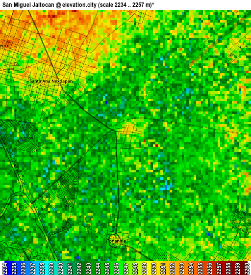
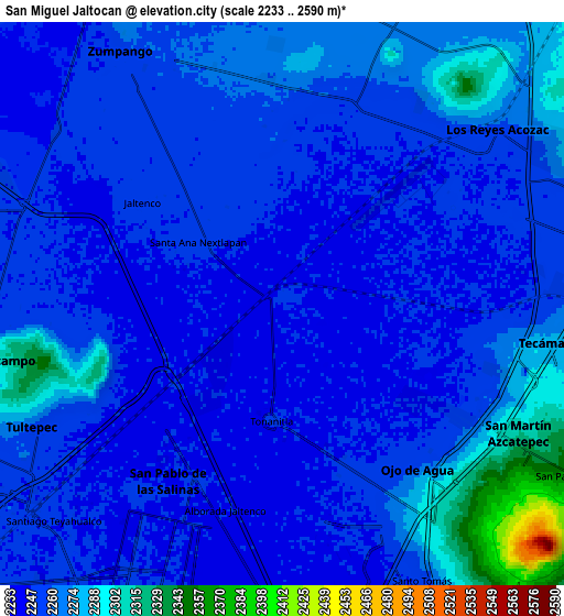
Below is the Elevation map of San Miguel Jaltocan, which displays elevation range with different colors. Scale of the first map is from 2234 to 2257 m (7329 to 7405 ft) with average elevation of 2245.5 meters (=7367 ft) [note 1]
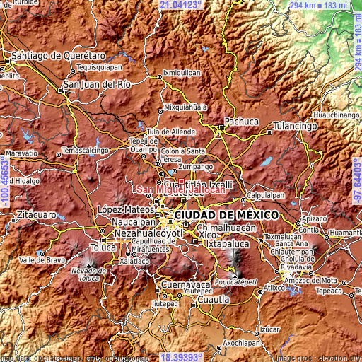
These maps also provides idea of topography and contour of this city, they are displayed at different zoom levels. More info about maps, scale and edge coordinates you can find below images.
| \ | Map #1 | Map #2 | Topo.Map |
| Scale [m] | 2234..2257 m | 2233..2590 m | × |
| Scale [ft] | 7329..7405 ft | 7326..8497 ft | × |
| Average | 2245.5 m = 7367 ft | 2259.9 m = 7414 ft | × |
| Width | 9.2 km = 5.7 mi | 18.4 km = 11.4 mi | 294.4 km = 182.9 mi |
| Height | 9.2 km = 5.7 mi | 18.4 km = 11.4 mi | 294.4 km = 182.9 mi |
| ↑Max Latitude | 19.764422° | 19.805773° | 21.04123° |
| Latitude at center | 19.72306° | 19.72306° | 19.72306° |
| ↓Min Latitude | 19.681687° | 19.640304° | 18.39393° |
| ← Min Longitude | -99.094225° | -99.138171° | -100.45653° |
| Longitude center | -99.05028° | -99.05028° | -99.05028° |
| →Max Longitude | -99.006335° | -98.962389° | -97.64403° |
Nearby cities:
Cities around San Miguel Jaltocan sort by population:
• Ojo de Agua elevation 2250 m
6.4 km,  138°
138°
• Santa Ana Nextlalpan 2251 m
3.3 km,  308°
308°
• Jaltenco 2253 m
5.6 km, 306°
• Tonanitla 2249 m
3.9 km,  184°
184°
• San Sebastián 2261 m
6.8 km,  355°
355°
• Ex-Hacienda Santa Inés 2244 m
3 km,  231°
231°
• Colonia la Asunción 2245 m
3.9 km,  202°
202°
• Prados San Francisco 2242 m
3.5 km,  267°
267°
• San Juan Pueblo Nuevo 2251 m
6.7 km,  28°
28°
• Colonia los Aguiluchos 2244 m
4.2 km, 274°
• San Antonio Xahuento 2247 m
6.9 km,  239°
239°
• Pueblo Nuevo de Morelos 2249 m
4.4 km, 355°
Multilingual:
 En español:
San Miguel Jaltocan elevación 2250 m.
 En France:
San Miguel Jaltocan élévation 2250 m.
 Auf Deutsch:
San Miguel Jaltocan höhe über dem Meeresspiegel ist 2250 m.
 На русском:
San Miguel Jaltocan высота над уровнем моря 2250 м
Sources and notes:
- [note 1] Map square and city borders are not equal. Map elevation data is calculated only from area inside that square.
- [src 1] Elevation data from geonames database provided with same terms of usage.
- [src 2] The elevation map of San Miguel Jaltocan is generated using elevation data from NASA's 3 arcsec (90m) resolution SRTM data.
- [src 3] Base (background) map © OpenStreetMap contributors tiles are generated by Geofabrik and OpenTopoMap.
Copyright & License:
This San Miguel Jaltocan Elevation Map is licensed under CC BY-SA. You may reuse any part from this page, if you give a proper credit by linking to this URL:
 More info on terms of use page.