Ex-Hacienda Santa Inés elevation
Ex-Hacienda Santa Inés (State of Mexico, Nextlalpan), Mexico elevation is 2244 meters and Ex-Hacienda Santa Inés elevation in feet is 7362 ft above sea level [src 1]. Ex-Hacienda Santa Inés is a populated place (feature code) with elevation that is 930 meters (3051 ft) bigger than average city elevation in Mexico.
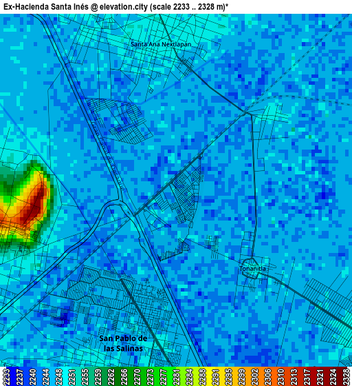
Below is the Elevation map of Ex-Hacienda Santa Inés, which displays elevation range with different colors. Scale of the first map is from 2233 to 2328 m (7326 to 7638 ft) with average elevation of 2246.2 meters (=7369 ft) [note 1]
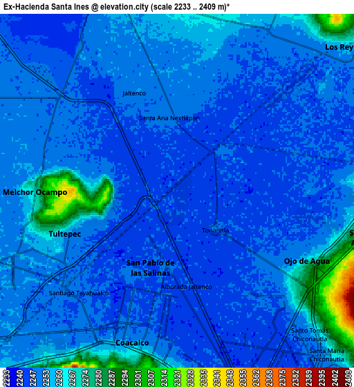
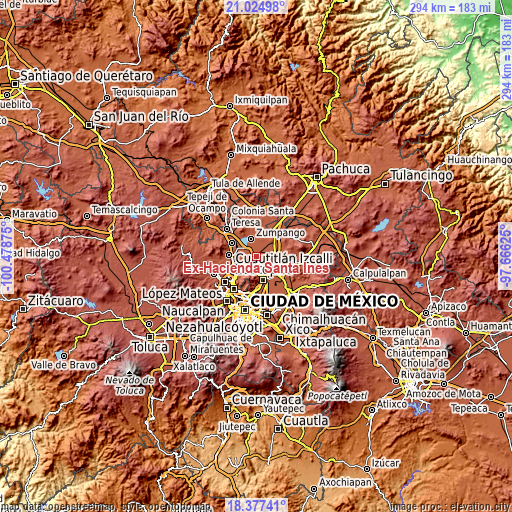
These maps also provides idea of topography and contour of this city, they are displayed at different zoom levels. More info about maps, scale and edge coordinates you can find below images.
| \ | Map #1 | Map #2 | Topo.Map |
| Scale [m] | 2233..2328 m | 2233..2409 m | × |
| Scale [ft] | 7326..7638 ft | 7326..7904 ft | × |
| Average | 2246.2 m = 7369 ft | 2252.9 m = 7391 ft | × |
| Width | 9.2 km = 5.7 mi | 18.4 km = 11.4 mi | 294.4 km = 182.9 mi |
| Height | 9.2 km = 5.7 mi | 18.4 km = 11.4 mi | 294.4 km = 182.9 mi |
| ↑Max Latitude | 19.748036° | 19.789392° | 21.02498° |
| Latitude at center | 19.70667° | 19.70667° | 19.70667° |
| ↓Min Latitude | 19.665293° | 19.623906° | 18.37741° |
| ← Min Longitude | -99.116445° | -99.160391° | -100.47875° |
| Longitude center | -99.0725° | -99.0725° | -99.0725° |
| →Max Longitude | -99.028555° | -98.984609° | -97.66625° |
Nearby cities:
Cities around Ex-Hacienda Santa Inés sort by population:
• San Pablo de las Salinas elevation 2248 m
5 km,  207°
207°
• Alborada Jaltenco 2245 m
5 km,  175°
175°
• Santa Ana Nextlalpan 2251 m
3.9 km,  356°
356°
• Tonanitla 2249 m
2.9 km,  136°
136°
• San Miguel Jaltocan 2250 m
3 km,  51°
51°
• Colonia 2 de Septiembre 2309 m
4.7 km,  261°
261°
• San Francisco Tenopalco 2254 m
4.6 km,  278°
278°
• Lomas de Tenopalco 2299 m
4.2 km, 263°
• Colonia la Asunción 2245 m
2 km,  153°
153°
• Prados San Francisco 2242 m
2 km,  324°
324°
• Colonia los Aguiluchos 2244 m
2.9 km, 319°
• San Antonio Xahuento 2247 m
4 km,  245°
245°
Multilingual:
 En español:
Ex-Hacienda Santa Inés elevación 2244 m.
 En France:
Ex-Hacienda Santa Inés élévation 2244 m.
 Auf Deutsch:
Ex-Hacienda Santa Inés höhe über dem Meeresspiegel ist 2244 m.
 На русском:
Ex-Hacienda Santa Inés высота над уровнем моря 2244 м
Sources and notes:
- [note 1] Map square and city borders are not equal. Map elevation data is calculated only from area inside that square.
- [src 1] Elevation data from geonames database provided with same terms of usage.
- [src 2] The elevation map of Ex-Hacienda Santa Inés is generated using elevation data from NASA's 3 arcsec (90m) resolution SRTM data.
- [src 3] Base (background) map © OpenStreetMap contributors tiles are generated by Geofabrik and OpenTopoMap.
Copyright & License:
This Ex-Hacienda Santa Inés Elevation Map is licensed under CC BY-SA. You may reuse any part from this page, if you give a proper credit by linking to this URL:
 More info on terms of use page.