Hacienda San Pedro elevation
Hacienda San Pedro (Nuevo León, General Zuazua), Mexico elevation is 398 meters and Hacienda San Pedro elevation in feet is 1306 ft above sea level [src 1]. Hacienda San Pedro is a populated place (feature code) with elevation that is 916 meters (3005 ft) smaller than average city elevation in Mexico.
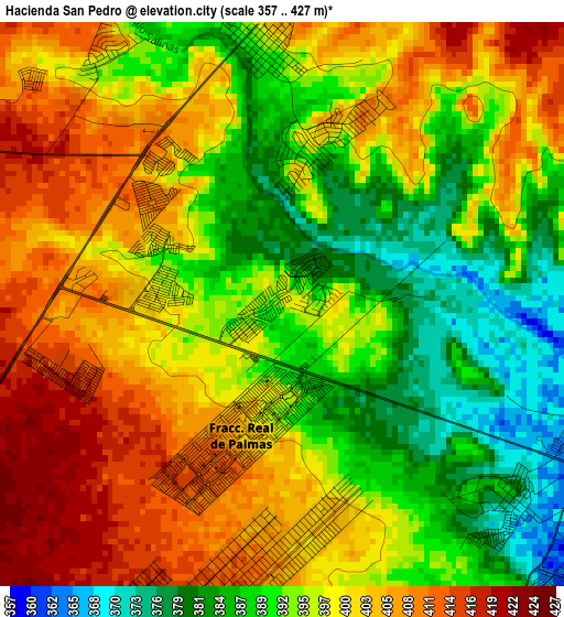
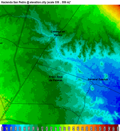
Below is the Elevation map of Hacienda San Pedro, which displays elevation range with different colors. Scale of the first map is from 357 to 427 m (1171 to 1401 ft) with average elevation of 396.9 meters (=1302 ft) [note 1]
These maps also provides idea of topography and contour of this city, they are displayed at different zoom levels. More info about maps, scale and edge coordinates you can find below images.
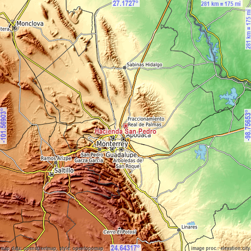
| \ | Map #1 | Map #2 | Topo.Map |
| Scale [m] | 357..427 m | 339..559 m | × |
| Scale [ft] | 1171..1401 ft | 1112..1834 ft | × |
| Average | 396.9 m = 1302 ft | 407.5 m = 1337 ft | × |
| Width | 8.79 km = 5.5 mi | 17.58 km = 10.9 mi | 281.3 km = 174.8 mi |
| Height | 8.79 km = 5.5 mi | 17.58 km = 10.9 mi | 281.3 km = 174.8 mi |
| ↑Max Latitude | 25.95424° | 25.993746° | 27.1727° |
| Latitude at center | 25.91472° | 25.91472° | 25.91472° |
| ↓Min Latitude | 25.875187° | 25.835641° | 24.64317° |
| ← Min Longitude | -100.206725° | -100.250671° | -101.56903° |
| Longitude center | -100.16278° | -100.16278° | -100.16278° |
| →Max Longitude | -100.118835° | -100.074889° | -98.75653° |
Nearby cities:
Cities around Hacienda San Pedro sort by population:
• Fraccionamiento Real Palmas elevation 389 m
1.2 km,  165°
165°
• Ciénega de Flores 399 m
4.5 km,  354°
354°
• General Zuazua 363 m
5.9 km,  111°
111°
• Santa Rosa 431 m
11.6 km,  210°
210°
• Emiliano Zapata 454 m
11.8 km,  267°
267°
• Real del Sol 409 m
3.2 km,  325°
325°
• Villas de Alcalá 403 m
2.3 km, 271°
• Colinas del Aeropuerto 383 m
12.4 km,  150°
150°
• Ciudad Satélite del Norte 444 m
10.3 km, 269°
• Entronque Laredo-Salinas Victoria 451 m
10.7 km,  231°
231°
• Portal de las Salinas 434 m
7.8 km,  14°
14°
• Artemio Treviño 401 m
9.1 km, 167°
Multilingual:
 En español:
Hacienda San Pedro elevación 398 m.
 En France:
Hacienda San Pedro élévation 398 m.
 Auf Deutsch:
Hacienda San Pedro höhe über dem Meeresspiegel ist 398 m.
 На русском:
Hacienda San Pedro высота над уровнем моря 398 м
Sources and notes:
- [note 1] Map square and city borders are not equal. Map elevation data is calculated only from area inside that square.
- [src 1] Elevation data from geonames database provided with same terms of usage.
- [src 2] The elevation map of Hacienda San Pedro is generated using elevation data from NASA's 3 arcsec (90m) resolution SRTM data.
- [src 3] Base (background) map © OpenStreetMap contributors tiles are generated by Geofabrik and OpenTopoMap.
Copyright & License:
This Hacienda San Pedro Elevation Map is licensed under CC BY-SA. You may reuse any part from this page, if you give a proper credit by linking to this URL:
 More info on terms of use page.