San Francisco Tepeyecac elevation
San Francisco Tepeyecac (Puebla, San Martín Texmelucan), Mexico elevation is 2287 meters and San Francisco Tepeyecac elevation in feet is 7503 ft above sea level [src 1]. San Francisco Tepeyecac is a populated place (feature code) with elevation that is 973 meters (3192 ft) bigger than average city elevation in Mexico.
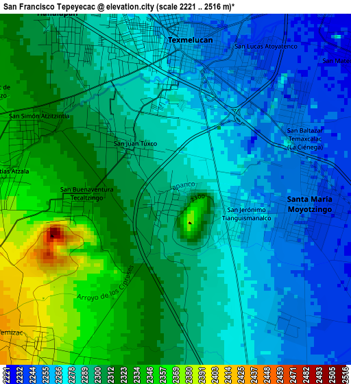
Below is the Elevation map of San Francisco Tepeyecac, which displays elevation range with different colors. Scale of the first map is from 2221 to 2516 m (7287 to 8255 ft) with average elevation of 2294.1 meters (=7527 ft) [note 1]
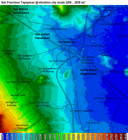
These maps also provides idea of topography and contour of this city, they are displayed at different zoom levels. More info about maps, scale and edge coordinates you can find below images.
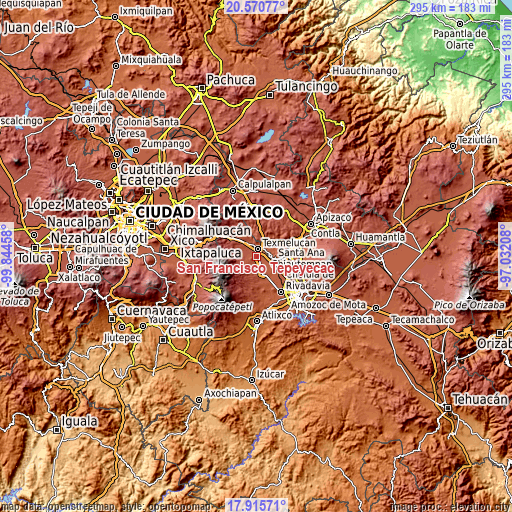
| \ | Map #1 | Map #2 | Topo.Map |
| Scale [m] | 2221..2516 m | 2200..2836 m | × |
| Scale [ft] | 7287..8255 ft | 7218..9304 ft | × |
| Average | 2294.1 m = 7527 ft | 2322.6 m = 7620 ft | × |
| Width | 9.23 km = 5.7 mi | 18.45 km = 11.5 mi | 295.2 km = 183.4 mi |
| Height | 9.23 km = 5.7 mi | 18.45 km = 11.5 mi | 295.2 km = 183.4 mi |
| ↑Max Latitude | 19.290093° | 19.331566° | 20.57077° |
| Latitude at center | 19.24861° | 19.24861° | 19.24861° |
| ↓Min Latitude | 19.207116° | 19.165612° | 17.91571° |
| ← Min Longitude | -98.482275° | -98.526221° | -99.84458° |
| Longitude center | -98.43833° | -98.43833° | -98.43833° |
| →Max Longitude | -98.394385° | -98.350439° | -97.03208° |
Nearby cities:
Cities around San Francisco Tepeyecac sort by population:
• San Martin Texmelucan de Labastida elevation 2260 m
4 km,  359°
359°
• Moyotzingo 2244 m
3.5 km,  90°
90°
• San Rafael Tlanalapan 2294 m
5.7 km,  326°
326°
• San Lorenzo Chiautzingo 2372 m
5.8 km,  211°
211°
• San Juan Tuxco 2298 m
1.8 km,  310°
310°
• Tianguismanalco 2264 m
1.8 km,  116°
116°
• San Buenaventura Tecaltzingo 2326 m
2.3 km,  267°
267°
• San Simón Atzitzintla 2329 m
4.3 km,  292°
292°
• San Mateo Ayecac 2228 m
5.7 km,  53°
53°
• San Matías Atzala 2348 m
4.6 km, 273°
• Tlacotepec de José Manzo 2340 m
5.5 km,  298°
298°
• San Luis Coyotzingo 2299 m
5.6 km,  178°
178°
Multilingual:
 En español:
San Francisco Tepeyecac elevación 2287 m.
 En France:
San Francisco Tepeyecac élévation 2287 m.
 Auf Deutsch:
San Francisco Tepeyecac höhe über dem Meeresspiegel ist 2287 m.
 На русском:
San Francisco Tepeyecac высота над уровнем моря 2287 м
Sources and notes:
- [note 1] Map square and city borders are not equal. Map elevation data is calculated only from area inside that square.
- [src 1] Elevation data from geonames database provided with same terms of usage.
- [src 2] The elevation map of San Francisco Tepeyecac is generated using elevation data from NASA's 3 arcsec (90m) resolution SRTM data.
- [src 3] Base (background) map © OpenStreetMap contributors tiles are generated by Geofabrik and OpenTopoMap.
Copyright & License:
This San Francisco Tepeyecac Elevation Map is licensed under CC BY-SA. You may reuse any part from this page, if you give a proper credit by linking to this URL:
 More info on terms of use page.