San Lorenzo Chiautzingo elevation
San Lorenzo Chiautzingo (Puebla, Chiautzingo), Mexico elevation is 2372 meters and San Lorenzo Chiautzingo elevation in feet is 7782 ft above sea level [src 1]. San Lorenzo Chiautzingo is a seat of a second-order administrative division (feature code) with elevation that is 1058 meters (3471 ft) bigger than average city elevation in Mexico.
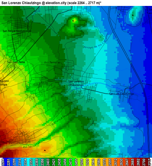
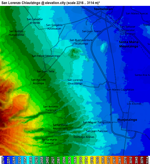
Below is the Elevation map of San Lorenzo Chiautzingo, which displays elevation range with different colors. Scale of the first map is from 2264 to 2717 m (7428 to 8914 ft) with average elevation of 2404.6 meters (=7889 ft) [note 1]
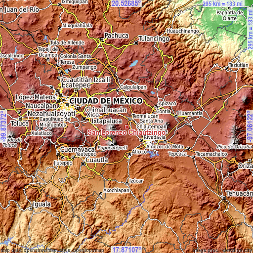
These maps also provides idea of topography and contour of this city, they are displayed at different zoom levels. More info about maps, scale and edge coordinates you can find below images.
| \ | Map #1 | Map #2 | Topo.Map |
| Scale [m] | 2264..2717 m | 2216..3114 m | × |
| Scale [ft] | 7428..8914 ft | 7270..10217 ft | × |
| Average | 2404.6 m = 7889 ft | 2431.5 m = 7977 ft | × |
| Width | 9.23 km = 5.7 mi | 18.46 km = 11.5 mi | 295.3 km = 183.5 mi |
| Height | 9.23 km = 5.7 mi | 18.46 km = 11.5 mi | 295.3 km = 183.5 mi |
| ↑Max Latitude | 19.245815° | 19.287299° | 20.52685° |
| Latitude at center | 19.20432° | 19.20432° | 19.20432° |
| ↓Min Latitude | 19.162815° | 19.121299° | 17.87107° |
| ← Min Longitude | -98.511415° | -98.555361° | -99.87372° |
| Longitude center | -98.46747° | -98.46747° | -98.46747° |
| →Max Longitude | -98.423525° | -98.379579° | -97.06122° |
Nearby cities:
Cities around San Lorenzo Chiautzingo sort by population:
• Teotlaltzingo elevation 2430 m
4.6 km,  310°
310°
• Tianguismanalco 2264 m
6.2 km,  48°
48°
• San Francisco Tepeyecac 2287 m
5.8 km,  31°
31°
• San Buenaventura Tecaltzingo 2326 m
4.9 km,  8°
8°
• San Juan Tetla 2490 m
4.1 km,  287°
287°
• San Antonio Tlatenco 2612 m
4.8 km,  224°
224°
• San Nicolás Zecalacoayan 2469 m
2.3 km,  255°
255°
• San Matías Atzala 2348 m
5.4 km,  344°
344°
• San Miguel Tianguizolco 2358 m
5.8 km,  151°
151°
• San Mateo Capultitlán 2258 m
5.6 km,  100°
100°
• San Agustín Atzompa 2574 m
4.9 km,  266°
266°
• San Luis Coyotzingo 2299 m
3.3 km, 102°
Multilingual:
 En español:
San Lorenzo Chiautzingo elevación 2372 m.
 En France:
San Lorenzo Chiautzingo élévation 2372 m.
 Auf Deutsch:
San Lorenzo Chiautzingo höhe über dem Meeresspiegel ist 2372 m.
 На русском:
San Lorenzo Chiautzingo высота над уровнем моря 2372 м
Sources and notes:
- [note 1] Map square and city borders are not equal. Map elevation data is calculated only from area inside that square.
- [src 1] Elevation data from geonames database provided with same terms of usage.
- [src 2] The elevation map of San Lorenzo Chiautzingo is generated using elevation data from NASA's 3 arcsec (90m) resolution SRTM data.
- [src 3] Base (background) map © OpenStreetMap contributors tiles are generated by Geofabrik and OpenTopoMap.
Copyright & License:
This San Lorenzo Chiautzingo Elevation Map is licensed under CC BY-SA. You may reuse any part from this page, if you give a proper credit by linking to this URL:
 More info on terms of use page.