La Ermita elevation
La Ermita (Guanajuato, León), Mexico elevation is 1975 meters and La Ermita elevation in feet is 6480 ft above sea level [src 1]. La Ermita is a populated place (feature code) with elevation that is 661 meters (2169 ft) bigger than average city elevation in Mexico.
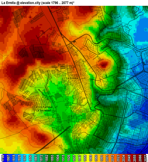
Below is the Elevation map of La Ermita, which displays elevation range with different colors. Scale of the first map is from 1796 to 2077 m (5892 to 6814 ft) with average elevation of 1949.7 meters (=6397 ft) [note 1]
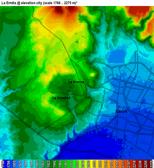
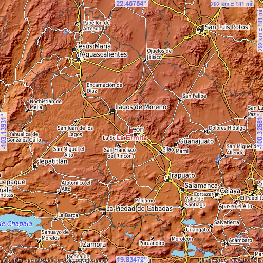
These maps also provides idea of topography and contour of this city, they are displayed at different zoom levels. More info about maps, scale and edge coordinates you can find below images.
| \ | Map #1 | Map #2 | Topo.Map |
| Scale [m] | 1796..2077 m | 1766..2275 m | × |
| Scale [ft] | 5892..6814 ft | 5794..7464 ft | × |
| Average | 1949.7 m = 6397 ft | 1919.4 m = 6297 ft | × |
| Width | 9.11 km = 5.7 mi | 18.23 km = 11.3 mi | 291.6 km = 181.2 mi |
| Height | 9.11 km = 5.7 mi | 18.23 km = 11.3 mi | 291.6 km = 181.2 mi |
| ↑Max Latitude | 21.192919° | 21.233886° | 22.45754° |
| Latitude at center | 21.15194° | 21.15194° | 21.15194° |
| ↓Min Latitude | 21.11095° | 21.069948° | 19.83472° |
| ← Min Longitude | -101.777005° | -101.820951° | -103.13931° |
| Longitude center | -101.73306° | -101.73306° | -101.73306° |
| →Max Longitude | -101.689115° | -101.645169° | -100.32681° |
Nearby cities:
Cities around La Ermita sort by population:
• León de los Aldama elevation 1806 m
6.7 km,  112°
112°
• Centro Familiar la Soledad 1935 m
2.6 km,  222°
222°
• Medina 1844 m
11.5 km,  91°
91°
• Plan de Ayala 1776 m
9 km,  172°
172°
• Rizos de la Joya (Rizos del Saucillo) 1967 m
3 km,  262°
262°
• Ibarrilla 1872 m
9.8 km,  66°
66°
• Santa Ana 1787 m
11.9 km,  150°
150°
• Fraccionamiento Paseo de las Torres 2059 m
3.2 km,  305°
305°
• Ejido la Joya 1933 m
1.2 km,  213°
213°
• Hacienda Arriba 1912 m
9.6 km,  18°
18°
• San José de Durán (Los Troncoso) 1787 m
11.6 km, 148°
• Malagana (San Antonio del Monte) 1769 m
11.9 km,  190°
190°
Multilingual:
 En español:
La Ermita elevación 1975 m.
 En France:
La Ermita élévation 1975 m.
 Auf Deutsch:
La Ermita höhe über dem Meeresspiegel ist 1975 m.

Sources and notes:
- [note 1] Map square and city borders are not equal. Map elevation data is calculated only from area inside that square.
- [src 1] Elevation data from geonames database provided with same terms of usage.
- [src 2] The elevation map of La Ermita is generated using elevation data from NASA's 3 arcsec (90m) resolution SRTM data.
- [src 3] Base (background) map © OpenStreetMap contributors tiles are generated by Geofabrik and OpenTopoMap.
Copyright & License:
This La Ermita Elevation Map is licensed under CC BY-SA. You may reuse any part from this page, if you give a proper credit by linking to this URL:
 More info on terms of use page.