Medina elevation
Medina (Guanajuato, León), Mexico elevation is 1844 meters and Medina elevation in feet is 6050 ft above sea level [src 1]. Medina is a populated place (feature code) with elevation that is 530 meters (1739 ft) bigger than average city elevation in Mexico.
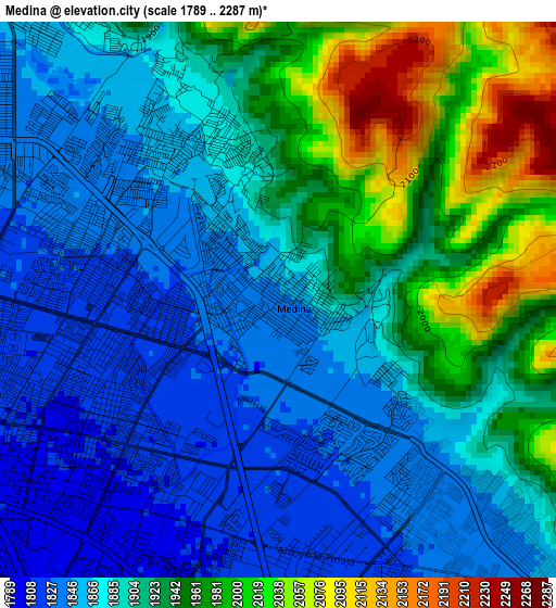
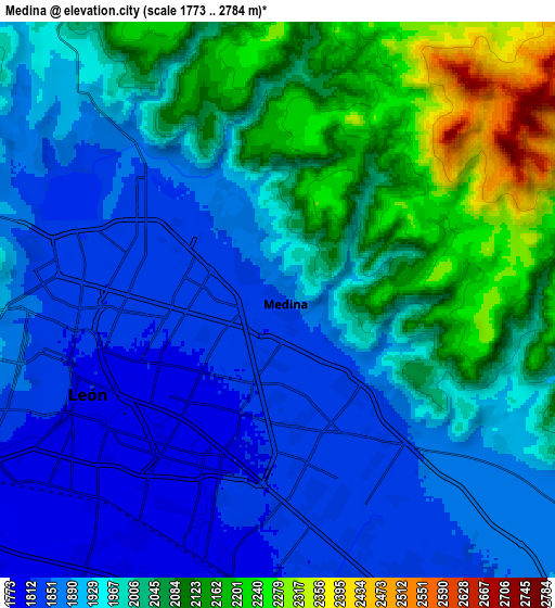
Below is the Elevation map of Medina, which displays elevation range with different colors. Scale of the first map is from 1789 to 2287 m (5869 to 7503 ft) with average elevation of 1906.2 meters (=6254 ft) [note 1]
These maps also provides idea of topography and contour of this city, they are displayed at different zoom levels. More info about maps, scale and edge coordinates you can find below images.
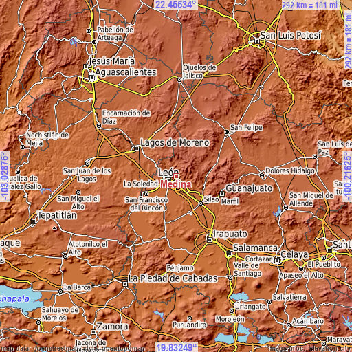
| \ | Map #1 | Map #2 | Topo.Map |
| Scale [m] | 1789..2287 m | 1773..2784 m | × |
| Scale [ft] | 5869..7503 ft | 5817..9134 ft | × |
| Average | 1906.2 m = 6254 ft | 1975.6 m = 6482 ft | × |
| Width | 9.11 km = 5.7 mi | 18.23 km = 11.3 mi | 291.6 km = 181.2 mi |
| Height | 9.11 km = 5.7 mi | 18.23 km = 11.3 mi | 291.7 km = 181.3 mi |
| ↑Max Latitude | 21.1907° | 21.231668° | 22.45534° |
| Latitude at center | 21.14972° | 21.14972° | 21.14972° |
| ↓Min Latitude | 21.108729° | 21.067727° | 19.83249° |
| ← Min Longitude | -101.666445° | -101.710391° | -103.02875° |
| Longitude center | -101.6225° | -101.6225° | -101.6225° |
| →Max Longitude | -101.578555° | -101.534609° | -100.21625° |
Nearby cities:
Cities around Medina sort by population:
• León de los Aldama elevation 1806 m
5.8 km,  246°
246°
• San Juan de Abajo 1800 m
10.5 km,  187°
187°
• San Juan de Otates 1902 m
7.7 km,  119°
119°
• Alfaro 1896 m
1.7 km,  91°
91°
• Ibarrilla 1872 m
4.8 km,  329°
329°
• Santa Ana 1787 m
11.5 km,  208°
208°
• Ladrilleras del Refugio 1862 m
10.2 km,  135°
135°
• San José del Potrero 1848 m
3.5 km,  132°
132°
• La Laborcita 1910 m
8.8 km, 123°
• Lucio Blanco (Los Gavilanes) 1920 m
8.3 km, 117°
• San José de Durán (Los Troncoso) 1787 m
11 km, 209°
• Fraccionamiento Paraíso Real 1851 m
6 km, 133°
Multilingual:
 En español:
Medina elevación 1844 m.
 En France:
Medina élévation 1844 m.


Sources and notes:
- [note 1] Map square and city borders are not equal. Map elevation data is calculated only from area inside that square.
- [src 1] Elevation data from geonames database provided with same terms of usage.
- [src 2] The elevation map of Medina is generated using elevation data from NASA's 3 arcsec (90m) resolution SRTM data.
- [src 3] Base (background) map © OpenStreetMap contributors tiles are generated by Geofabrik and OpenTopoMap.
Copyright & License:
This Medina Elevation Map is licensed under CC BY-SA. You may reuse any part from this page, if you give a proper credit by linking to this URL:
 More info on terms of use page.