San Juan de Abajo elevation
San Juan de Abajo (Guanajuato, León), Mexico elevation is 1800 meters and San Juan de Abajo elevation in feet is 5906 ft above sea level [src 1]. San Juan de Abajo is a populated place (feature code) with elevation that is 486 meters (1594 ft) bigger than average city elevation in Mexico.
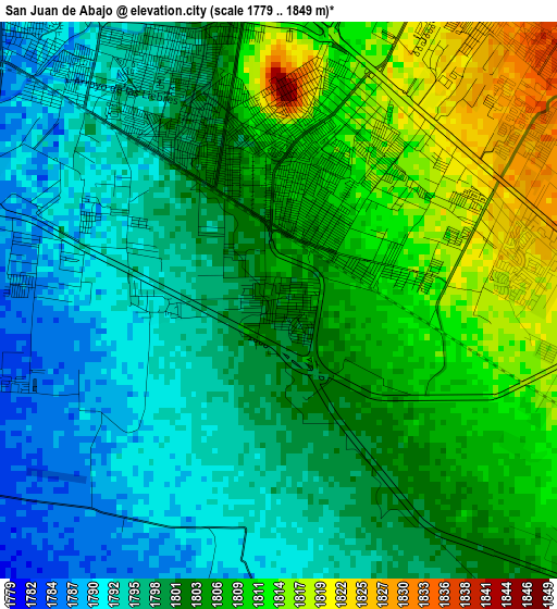
Below is the Elevation map of San Juan de Abajo, which displays elevation range with different colors. Scale of the first map is from 1779 to 1849 m (5837 to 6066 ft) with average elevation of 1802.2 meters (=5913 ft) [note 1]
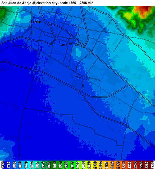
These maps also provides idea of topography and contour of this city, they are displayed at different zoom levels. More info about maps, scale and edge coordinates you can find below images.
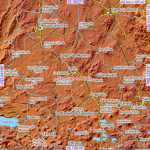
| \ | Map #1 | Map #2 | Topo.Map |
| Scale [m] | 1779..1849 m | 1766..2308 m | × |
| Scale [ft] | 5837..6066 ft | 5794..7572 ft | × |
| Average | 1802.2 m = 5913 ft | 1811.7 m = 5944 ft | × |
| Width | 9.12 km = 5.7 mi | 18.24 km = 11.3 mi | 291.8 km = 181.3 mi |
| Height | 9.12 km = 5.7 mi | 18.24 km = 11.3 mi | 291.8 km = 181.3 mi |
| ↑Max Latitude | 21.097235° | 21.138229° | 22.3627° |
| Latitude at center | 21.05623° | 21.05623° | 21.05623° |
| ↓Min Latitude | 21.015213° | 20.974185° | 19.73819° |
| ← Min Longitude | -101.679385° | -101.723331° | -103.04169° |
| Longitude center | -101.63544° | -101.63544° | -101.63544° |
| →Max Longitude | -101.591495° | -101.547549° | -100.22919° |
Nearby cities:
Cities around San Juan de Abajo sort by population:
• León de los Aldama elevation 1806 m
9 km,  333°
333°
• Los Ramírez 1792 m
4.2 km,  192°
192°
• San Francisco de Durán 1792 m
5.9 km,  164°
164°
• Santa Ana 1787 m
4.2 km,  274°
274°
• Colonia Latinoamericana 1779 m
7.9 km,  248°
248°
• Ladrilleras del Refugio 1862 m
9.1 km,  69°
69°
• San José del Potrero 1848 m
8.9 km,  26°
26°
• El CERESO 1780 m
6.7 km,  235°
235°
• San José de Durán (Los Troncoso) 1787 m
4.1 km,  280°
280°
• Los Arcos 1781 m
5.6 km,  262°
262°
• Fraccionamiento Paraíso Real 1851 m
8.4 km,  42°
42°
• San Antonio de los Tepetates 1784 m
4.4 km, 253°
Multilingual:
 En español:
San Juan de Abajo elevación 1800 m.
 En France:
San Juan de Abajo élévation 1800 m.
 Auf Deutsch:
San Juan de Abajo höhe über dem Meeresspiegel ist 1800 m.
 На русском:
San Juan de Abajo высота над уровнем моря 1800 м
Sources and notes:
- [note 1] Map square and city borders are not equal. Map elevation data is calculated only from area inside that square.
- [src 1] Elevation data from geonames database provided with same terms of usage.
- [src 2] The elevation map of San Juan de Abajo is generated using elevation data from NASA's 3 arcsec (90m) resolution SRTM data.
- [src 3] Base (background) map © OpenStreetMap contributors tiles are generated by Geofabrik and OpenTopoMap.
Copyright & License:
This San Juan de Abajo Elevation Map is licensed under CC BY-SA. You may reuse any part from this page, if you give a proper credit by linking to this URL:
 More info on terms of use page.