Arcila elevation
Arcila (Querétaro, San Juan del Río), Mexico elevation is 1974 meters and Arcila elevation in feet is 6476 ft above sea level [src 1]. Arcila is a populated place (feature code) with elevation that is 660 meters (2165 ft) bigger than average city elevation in Mexico.
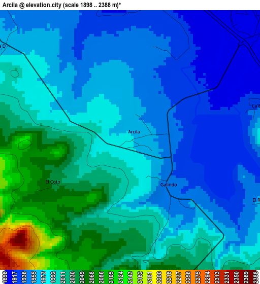
Below is the Elevation map of Arcila, which displays elevation range with different colors. Scale of the first map is from 1898 to 2388 m (6227 to 7835 ft) with average elevation of 1985.3 meters (=6513 ft) [note 1]
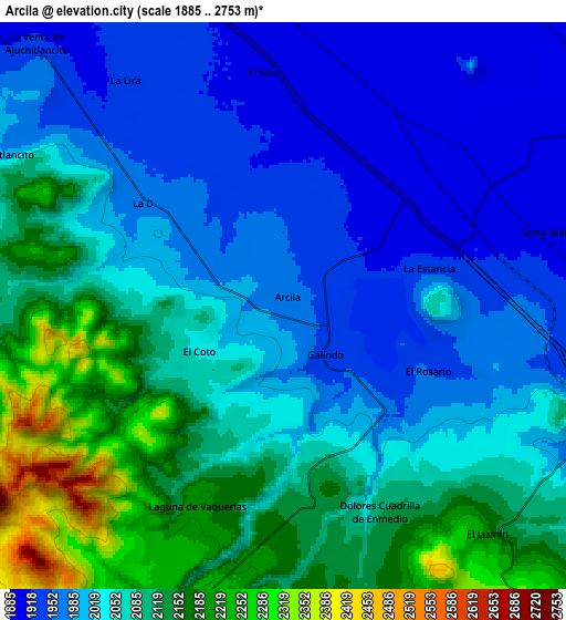
These maps also provides idea of topography and contour of this city, they are displayed at different zoom levels. More info about maps, scale and edge coordinates you can find below images.
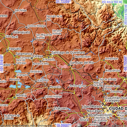
| \ | Map #1 | Map #2 | Topo.Map |
| Scale [m] | 1898..2388 m | 1885..2753 m | × |
| Scale [ft] | 6227..7835 ft | 6184..9032 ft | × |
| Average | 1985.3 m = 6513 ft | 2049.2 m = 6723 ft | × |
| Width | 9.16 km = 5.7 mi | 18.32 km = 11.4 mi | 293.1 km = 182.1 mi |
| Height | 9.16 km = 5.7 mi | 18.32 km = 11.4 mi | 293.1 km = 182.1 mi |
| ↑Max Latitude | 20.451551° | 20.492721° | 21.72259° |
| Latitude at center | 20.41037° | 20.41037° | 20.41037° |
| ↓Min Latitude | 20.369178° | 20.327975° | 19.08687° |
| ← Min Longitude | -100.153875° | -100.197821° | -101.51618° |
| Longitude center | -100.10993° | -100.10993° | -100.10993° |
| →Max Longitude | -100.065985° | -100.022039° | -98.70368° |
Nearby cities:
Cities around Arcila sort by population:
• El Saúz elevation 1908 m
7.5 km,  355°
355°
• La Lira 1921 m
9 km,  323°
323°
• La Estancia 1938 m
4.7 km,  75°
75°
• La D 1962 m
5.6 km,  306°
306°
• Galindo 1948 m
1.9 km,  140°
140°
• El Organal 1910 m
9.4 km,  37°
37°
• Loma Linda 1967 m
8.3 km,  97°
97°
• El Rosario 1952 m
5 km,  114°
114°
• Dolores Cuadrilla de Enmedio 2106 m
7.2 km,  153°
153°
• Santa Matilde 1908 m
9.1 km,  74°
74°
• El Coto 2044 m
3.1 km,  236°
236°
• Laguna de Vaquerías 2201 m
6.8 km,  202°
202°
Multilingual:
 En español:
Arcila elevación 1974 m.
 En France:
Arcila élévation 1974 m.


Sources and notes:
- [note 1] Map square and city borders are not equal. Map elevation data is calculated only from area inside that square.
- [src 1] Elevation data from geonames database provided with same terms of usage.
- [src 2] The elevation map of Arcila is generated using elevation data from NASA's 3 arcsec (90m) resolution SRTM data.
- [src 3] Base (background) map © OpenStreetMap contributors tiles are generated by Geofabrik and OpenTopoMap.
Copyright & License:
This Arcila Elevation Map is licensed under CC BY-SA. You may reuse any part from this page, if you give a proper credit by linking to this URL:
 More info on terms of use page.