La Solana elevation
La Solana (Querétaro), Mexico elevation is 2057 meters and La Solana elevation in feet is 6749 ft above sea level [src 1]. La Solana is a populated place (feature code) with elevation that is 743 meters (2438 ft) bigger than average city elevation in Mexico.
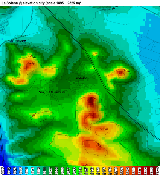
Below is the Elevation map of La Solana, which displays elevation range with different colors. Scale of the first map is from 1895 to 2325 m (6217 to 7628 ft) with average elevation of 2045.9 meters (=6712 ft) [note 1]
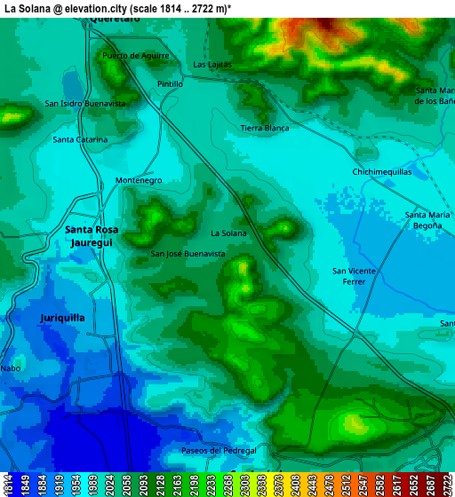
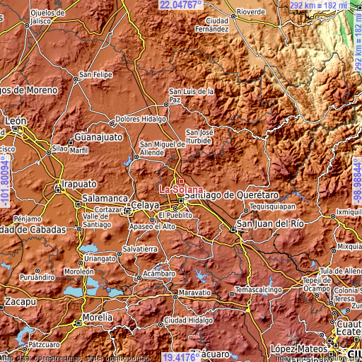
These maps also provides idea of topography and contour of this city, they are displayed at different zoom levels. More info about maps, scale and edge coordinates you can find below images.
| \ | Map #1 | Map #2 | Topo.Map |
| Scale [m] | 1895..2325 m | 1814..2722 m | × |
| Scale [ft] | 6217..7628 ft | 5951..8930 ft | × |
| Average | 2045.9 m = 6712 ft | 2025.5 m = 6645 ft | × |
| Width | 9.14 km = 5.7 mi | 18.28 km = 11.4 mi | 292.4 km = 181.7 mi |
| Height | 9.14 km = 5.7 mi | 18.28 km = 11.4 mi | 292.5 km = 181.8 mi |
| ↑Max Latitude | 20.779442° | 20.820524° | 22.04767° |
| Latitude at center | 20.73835° | 20.73835° | 20.73835° |
| ↓Min Latitude | 20.697246° | 20.656132° | 19.4176° |
| ← Min Longitude | -100.438635° | -100.482581° | -101.80094° |
| Longitude center | -100.39469° | -100.39469° | -100.39469° |
| →Max Longitude | -100.350745° | -100.306799° | -98.98844° |
Nearby cities:
Cities around La Solana sort by population:
• Santa Rosa Jauregui elevation 1963 m
5.6 km,  273°
273°
• Juriquilla 1907 m
7 km,  245°
245°
• Chichimequillas 1966 m
6.8 km,  64°
64°
• Montenegro 1979 m
4.5 km,  308°
308°
• Tierra Blanca 2031 m
4.9 km,  18°
18°
• San Vicente Ferrer 1951 m
5.2 km,  103°
103°
• Santa Catarina 1981 m
7.4 km, 305°
• San José Buenavista 2054 m
1.6 km,  256°
256°
• El Pinto 2023 m
7.4 km,  346°
346°
• Ninguno [CERESO] 2180 m
8 km,  153°
153°
• Pintillo 2023 m
6.9 km,  340°
340°
• Las Lajitas 2075 m
7.3 km, 354°
Multilingual:
 En español:
La Solana elevación 2057 m.
 En France:
La Solana élévation 2057 m.
 Auf Deutsch:
La Solana höhe über dem Meeresspiegel ist 2057 m.

Sources and notes:
- [note 1] Map square and city borders are not equal. Map elevation data is calculated only from area inside that square.
- [src 1] Elevation data from geonames database provided with same terms of usage.
- [src 2] The elevation map of La Solana is generated using elevation data from NASA's 3 arcsec (90m) resolution SRTM data.
- [src 3] Base (background) map © OpenStreetMap contributors tiles are generated by Geofabrik and OpenTopoMap.
Copyright & License:
This La Solana Elevation Map is licensed under CC BY-SA. You may reuse any part from this page, if you give a proper credit by linking to this URL:
 More info on terms of use page.