Cuto del Porvenir elevation
Cuto del Porvenir (Michoacán, Tarímbaro), Mexico elevation is 1913 meters and Cuto del Porvenir elevation in feet is 6276 ft above sea level [src 1]. Cuto del Porvenir is a populated place (feature code) with elevation that is 599 meters (1965 ft) bigger than average city elevation in Mexico.
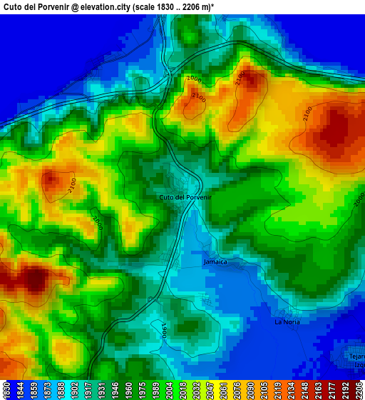
Below is the Elevation map of Cuto del Porvenir, which displays elevation range with different colors. Scale of the first map is from 1830 to 2206 m (6004 to 7238 ft) with average elevation of 1959.8 meters (=6430 ft) [note 1]
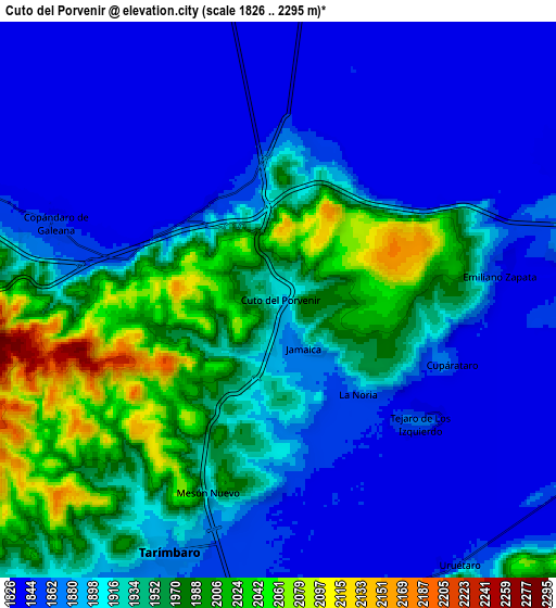
These maps also provides idea of topography and contour of this city, they are displayed at different zoom levels. More info about maps, scale and edge coordinates you can find below images.
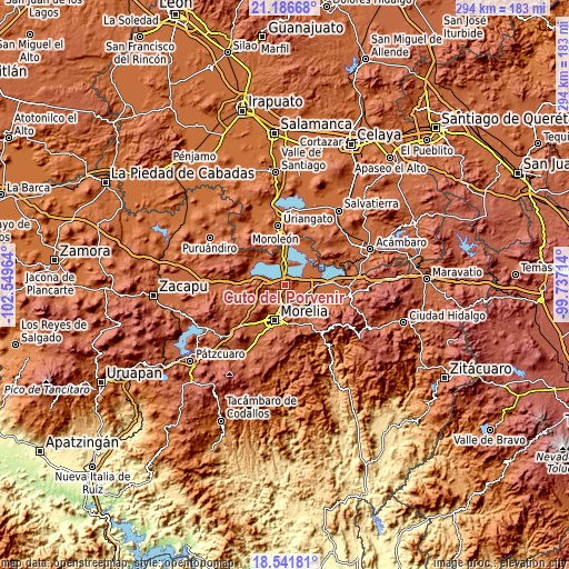
| \ | Map #1 | Map #2 | Topo.Map |
| Scale [m] | 1830..2206 m | 1826..2295 m | × |
| Scale [ft] | 6004..7238 ft | 5991..7530 ft | × |
| Average | 1959.8 m = 6430 ft | 1908.6 m = 6262 ft | × |
| Width | 9.19 km = 5.7 mi | 18.38 km = 11.4 mi | 294.1 km = 182.7 mi |
| Height | 9.19 km = 5.7 mi | 18.38 km = 11.4 mi | 294.1 km = 182.7 mi |
| ↑Max Latitude | 19.911084° | 19.952397° | 21.18668° |
| Latitude at center | 19.86976° | 19.86976° | 19.86976° |
| ↓Min Latitude | 19.828425° | 19.78708° | 18.54181° |
| ← Min Longitude | -101.187335° | -101.231281° | -102.54964° |
| Longitude center | -101.14339° | -101.14339° | -101.14339° |
| →Max Longitude | -101.099445° | -101.055499° | -99.73714° |
Nearby cities:
Cities around Cuto del Porvenir sort by population:
• Tarímbaro elevation 1895 m
9 km,  203°
203°
• Copándaro de Galeana 1849 m
7.8 km,  288°
288°
• Campestre Tarímbaro 1850 m
10.6 km,  171°
171°
• San Juan Benito Juárez (San Juan Tararameo) 1846 m
5.5 km,  16°
16°
• Uruétaro 1851 m
10.6 km,  146°
146°
• San Pedro de los Sauces 1845 m
9.3 km,  176°
176°
• San Agustín del Maíz 1842 m
3.9 km,  325°
325°
• Mesón Nuevo (Cañada de la Magdalena) 1907 m
6.6 km, 201°
• Colonia Miguel Hidalgo 1847 m
10.3 km, 154°
• Jamaica 1895 m
1.8 km, 150°
• El Cuitzillo Grande 1858 m
10.4 km,  164°
164°
• Cuparátaro 1862 m
6.1 km,  110°
110°
Multilingual:
 En español:
Cuto del Porvenir elevación 1913 m.
 En France:
Cuto del Porvenir élévation 1913 m.
 Auf Deutsch:
Cuto del Porvenir höhe über dem Meeresspiegel ist 1913 m.
 На русском:
Cuto del Porvenir высота над уровнем моря 1913 м
Sources and notes:
- [note 1] Map square and city borders are not equal. Map elevation data is calculated only from area inside that square.
- [src 1] Elevation data from geonames database provided with same terms of usage.
- [src 2] The elevation map of Cuto del Porvenir is generated using elevation data from NASA's 3 arcsec (90m) resolution SRTM data.
- [src 3] Base (background) map © OpenStreetMap contributors tiles are generated by Geofabrik and OpenTopoMap.
Copyright & License:
This Cuto del Porvenir Elevation Map is licensed under CC BY-SA. You may reuse any part from this page, if you give a proper credit by linking to this URL:
 More info on terms of use page.