La Calera elevation
La Calera (Guanajuato, Salvatierra), Mexico elevation is 1757 meters and La Calera elevation in feet is 5764 ft above sea level [src 1]. La Calera is a populated place (feature code) with elevation that is 443 meters (1453 ft) bigger than average city elevation in Mexico.
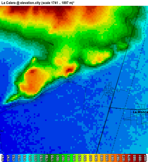
Below is the Elevation map of La Calera, which displays elevation range with different colors. Scale of the first map is from 1741 to 1897 m (5712 to 6224 ft) with average elevation of 1780.7 meters (=5842 ft) [note 1]
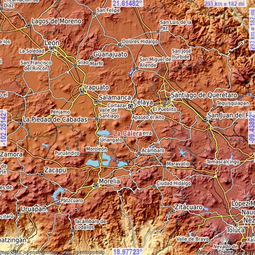
These maps also provides idea of topography and contour of this city, they are displayed at different zoom levels. More info about maps, scale and edge coordinates you can find below images.
| \ | Map #1 | Topo.Map |
| Scale [m] | 1741..1897 m | × |
| Scale [ft] | 5712..6224 ft | × |
| Average | 1780.7 m = 5842 ft | × |
| Width | 9.17 km = 5.7 mi | 293.3 km = 182.2 mi |
| Height | 9.17 km = 5.7 mi | 293.3 km = 182.2 mi |
| ↑Max Latitude | 20.34285° | 21.61482° |
| Latitude at center | 20.30164° | 20.30164° |
| ↓Min Latitude | 20.260419° | 18.97723° |
| ← Min Longitude | -100.889115° | -102.25142° |
| Longitude center | -100.84517° | -100.84517° |
| →Max Longitude | -100.801225° | -99.43892° |
Nearby cities:
Cities around La Calera sort by population:
• Salvatierra elevation 1761 m
10.5 km,  200°
200°
• Tarimoro 1784 m
9.6 km,  102°
102°
• Urireo 1796 m
9.8 km,  178°
178°
• La Moncada 1761 m
4.6 km,  115°
115°
• Panales Jamaica (Cañones) 1757 m
2.4 km,  106°
106°
• Ojo de Agua de Ballesteros 1761 m
8.5 km,  165°
165°
• Galerade Panales 1758 m
3.3 km, 103°
• La Luz 1746 m
7.7 km,  259°
259°
• San Juan Bautista Cacalote 1773 m
7.9 km,  48°
48°
• La Estancia de San José del Carmen 1757 m
1.8 km,  247°
247°
• El Salvador (Ranchito San José del Carmen) 1752 m
3.7 km,  244°
244°
• San Nicolás de la Condesa 1804 m
10.2 km,  138°
138°
Multilingual:
 En español:
La Calera elevación 1757 m.
 En France:
La Calera élévation 1757 m.
 Auf Deutsch:
La Calera höhe über dem Meeresspiegel ist 1757 m.

Sources and notes:
- [note 1] Map square and city borders are not equal. Map elevation data is calculated only from area inside that square.
- [src 1] Elevation data from geonames database provided with same terms of usage.
- [src 2] The elevation map of La Calera is generated using elevation data from NASA's 3 arcsec (90m) resolution SRTM data.
- [src 3] Base (background) map © OpenStreetMap contributors tiles are generated by Geofabrik and OpenTopoMap.
Copyright & License:
This La Calera Elevation Map is licensed under CC BY-SA. You may reuse any part from this page, if you give a proper credit by linking to this URL:
 More info on terms of use page.