La Ciénega elevation
La Ciénega (Guanajuato, San Luis de la Paz), Mexico elevation is 2064 meters and La Ciénega elevation in feet is 6772 ft above sea level [src 1]. La Ciénega is a populated place (feature code) with elevation that is 750 meters (2461 ft) bigger than average city elevation in Mexico.
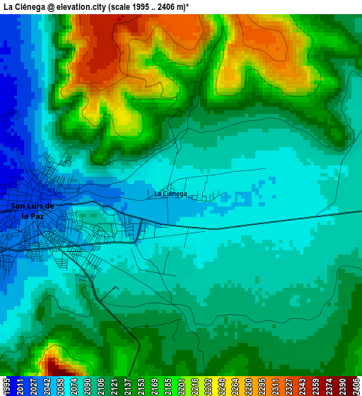
Below is the Elevation map of La Ciénega, which displays elevation range with different colors. Scale of the first map is from 1995 to 2406 m (6545 to 7894 ft) with average elevation of 2119.1 meters (=6952 ft) [note 1]
These maps also provides idea of topography and contour of this city, they are displayed at different zoom levels. More info about maps, scale and edge coordinates you can find below images.
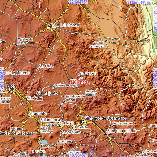
| \ | Map #1 | Topo.Map |
| Scale [m] | 1995..2406 m | × |
| Scale [ft] | 6545..7894 ft | × |
| Average | 2119.1 m = 6952 ft | × |
| Width | 9.1 km = 5.7 mi | 291.3 km = 181 mi |
| Height | 9.1 km = 5.7 mi | 291.4 km = 181.1 mi |
| ↑Max Latitude | 21.341438° | 22.60475° |
| Latitude at center | 21.3005° | 21.3005° |
| ↓Min Latitude | 21.259551° | 19.98457° |
| ← Min Longitude | -100.524215° | -101.88652° |
| Longitude center | -100.48027° | -100.48027° |
| →Max Longitude | -100.436325° | -99.07402° |
Nearby cities:
Cities around La Ciénega sort by population:
• San Luis de la Paz elevation 2019 m
3.9 km,  265°
265°
• Misión de Chichimecas 2081 m
1.8 km,  200°
200°
• Doctor Mora 2125 m
24.2 km,  136°
136°
• San Sebastián de Salitre 2028 m
22 km,  180°
180°
• Los Dolores (Las Quince Letras) 1999 m
9.1 km,  282°
282°
• San Nicolás del Cármen 1998 m
7.8 km,  247°
247°
• San Antonio Primero 2040 m
23.5 km,  192°
192°
• San Ignacio 2012 m
6.3 km, 250°
• Cieneguilla 1834 m
22.2 km,  105°
105°
• Tulillos de Abajo 2031 m
23.9 km, 180°
• La Sabana 1995 m
24.4 km,  242°
242°
• Derramadero Segundo (Infiernillo) 2038 m
22.8 km, 188°
Multilingual:
 En español:
La Ciénega elevación 2064 m.
 En France:
La Ciénega élévation 2064 m.
 Auf Deutsch:
La Ciénega höhe über dem Meeresspiegel ist 2064 m.

Sources and notes:
- [note 1] Map square and city borders are not equal. Map elevation data is calculated only from area inside that square.
- [src 1] Elevation data from geonames database provided with same terms of usage.
- [src 2] The elevation map of La Ciénega is generated using elevation data from NASA's 3 arcsec (90m) resolution SRTM data.
- [src 3] Base (background) map © OpenStreetMap contributors tiles are generated by Geofabrik and OpenTopoMap.
Copyright & License:
This La Ciénega Elevation Map is licensed under CC BY-SA. You may reuse any part from this page, if you give a proper credit by linking to this URL:
 More info on terms of use page.