Cieneguilla elevation
Cieneguilla (Guanajuato, Victoria), Mexico elevation is 1834 meters and Cieneguilla elevation in feet is 6017 ft above sea level [src 1]. Cieneguilla is a populated place (feature code) with elevation that is 520 meters (1706 ft) bigger than average city elevation in Mexico.
Below is the Elevation map of Cieneguilla, which displays elevation range with different colors. Scale of the first map is from 1757 to 2377 m (5764 to 7799 ft) with average elevation of 1926 meters (=6319 ft) [note 1]
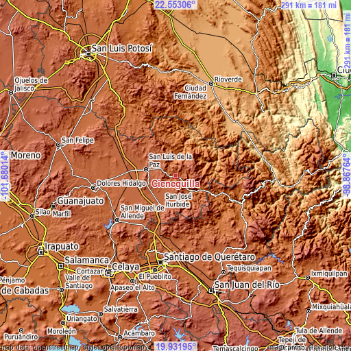
These maps also provides idea of topography and contour of this city, they are displayed at different zoom levels. More info about maps, scale and edge coordinates you can find below images.
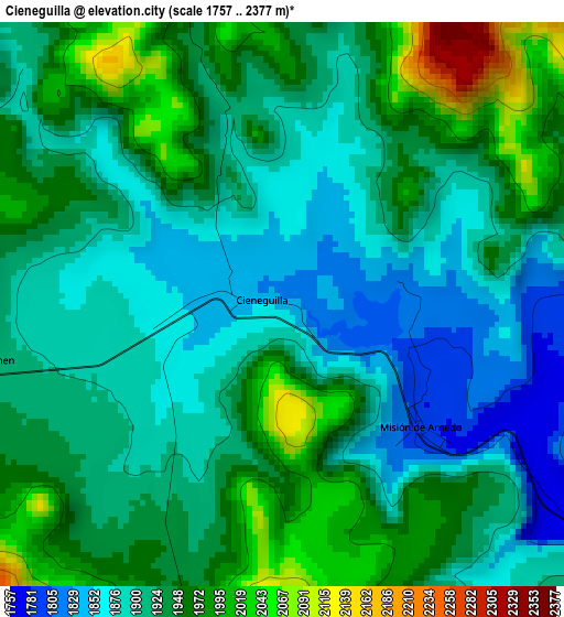
| \ | Map #1 | Topo.Map |
| Scale [m] | 1757..2377 m | × |
| Scale [ft] | 5764..7799 ft | × |
| Average | 1926 m = 6319 ft | × |
| Width | 9.11 km = 5.7 mi | 291.4 km = 181.1 mi |
| Height | 9.11 km = 5.7 mi | 291.5 km = 181.1 mi |
| ↑Max Latitude | 21.289282° | 22.55306° |
| Latitude at center | 21.24833° | 21.24833° |
| ↓Min Latitude | 21.207366° | 19.93195° |
| ← Min Longitude | -100.317835° | -101.68014° |
| Longitude center | -100.27389° | -100.27389° |
| →Max Longitude | -100.229945° | -98.86764° |
Nearby cities:
Cities around Cieneguilla sort by population:
• San Luis de la Paz elevation 2019 m
25.8 km,  282°
282°
• Misión de Chichimecas 2081 m
22.4 km, 280°
• Doctor Mora 2125 m
12.7 km,  201°
201°
• El Capulín 2136 m
23.7 km,  192°
192°
• Victoria 1751 m
7.3 km,  123°
123°
• Tierra Blanca 1702 m
20.3 km,  144°
144°
• La Ciénega 2064 m
22.2 km,  285°
285°
• Xichú 1317 m
23.1 km,  75°
75°
• Santa Catarina 1586 m
24.2 km, 119°
• Rincón de Cano 1919 m
21.7 km,  171°
171°
• Cuesta de Peñones 1924 m
18.7 km, 168°
• Los Remedios 1780 m
10.5 km,  132°
132°
Multilingual:
 En español:
Cieneguilla elevación 1834 m.
 En France:
Cieneguilla élévation 1834 m.
 Auf Deutsch:
Cieneguilla höhe über dem Meeresspiegel ist 1834 m.

Sources and notes:
- [note 1] Map square and city borders are not equal. Map elevation data is calculated only from area inside that square.
- [src 1] Elevation data from geonames database provided with same terms of usage.
- [src 2] The elevation map of Cieneguilla is generated using elevation data from NASA's 3 arcsec (90m) resolution SRTM data.
- [src 3] Base (background) map © OpenStreetMap contributors tiles are generated by Geofabrik and OpenTopoMap.
Copyright & License:
This Cieneguilla Elevation Map is licensed under CC BY-SA. You may reuse any part from this page, if you give a proper credit by linking to this URL:
 More info on terms of use page.