Aguililla elevation
Aguililla (Michoacán), Mexico elevation is 923 meters and Aguililla elevation in feet is 3028 ft above sea level [src 1]. Aguililla is a seat of a second-order administrative division (feature code) with elevation that is 391 meters (1283 ft) smaller than average city elevation in Mexico.
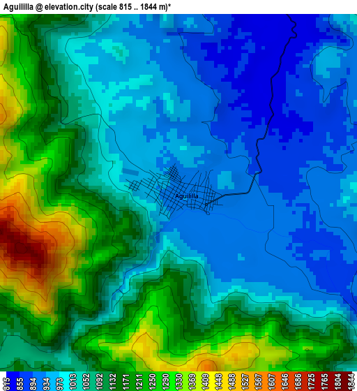
Below is the Elevation map of Aguililla, which displays elevation range with different colors. Scale of the first map is from 815 to 1844 m (2674 to 6050 ft) with average elevation of 1067.4 meters (=3502 ft) [note 1]
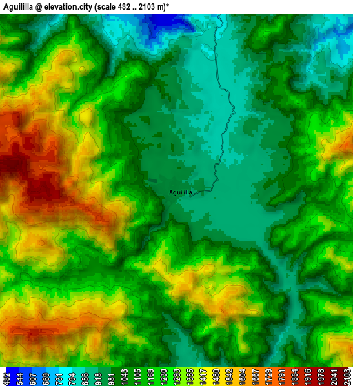
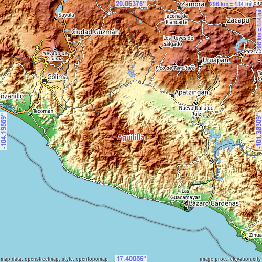
These maps also provides idea of topography and contour of this city, they are displayed at different zoom levels. More info about maps, scale and edge coordinates you can find below images.
| \ | Map #1 | Map #2 | Topo.Map |
| Scale [m] | 815..1844 m | 482..2103 m | × |
| Scale [ft] | 2674..6050 ft | 1581..6900 ft | × |
| Average | 1067.4 m = 3502 ft | 1169.1 m = 3836 ft | × |
| Width | 9.25 km = 5.7 mi | 18.51 km = 11.5 mi | 296.1 km = 184 mi |
| Height | 9.25 km = 5.7 mi | 18.51 km = 11.5 mi | 296.1 km = 184 mi |
| ↑Max Latitude | 18.779031° | 18.820632° | 20.06378° |
| Latitude at center | 18.73742° | 18.73742° | 18.73742° |
| ↓Min Latitude | 18.695799° | 18.654167° | 17.40056° |
| ← Min Longitude | -102.833285° | -102.877231° | -104.19559° |
| Longitude center | -102.78934° | -102.78934° | -102.78934° |
| →Max Longitude | -102.745395° | -102.701449° | -101.38309° |
Nearby cities:
Cities around Aguililla sort by population:
• Tepalcatepec elevation 397 m
50.3 km,  352°
352°
• La Mira Tumbiscatio 495 m
53.6 km,  96°
96°
• Coalcomán de Vázquez Pallares 1027 m
39.3 km,  276°
276°
• Felipe Carrillo Puerto 334 m
48.1 km,  10°
10°
• Santa Ana Amatlán 321 m
53.9 km,  29°
29°
• Tumbiscatío de Ruiz 919 m
49.2 km,  118°
118°
• Cenobio Moreno 248 m
49.9 km,  36°
36°
• Bonifacio Moreno (El Aguaje) 282 m
29.5 km,  16°
16°
• Pinzándaro 259 m
48.9 km, 32°
• Loma de los Hoyos 242 m
49.3 km,  47°
47°
• División del Norte 272 m
42.6 km, 25°
• Los Olivos 420 m
52.9 km, 351°
Multilingual:
 En español:
Aguililla elevación 923 m.
 En France:
Aguililla élévation 923 m.
 Auf Deutsch:
Aguililla höhe über dem Meeresspiegel ist 923 m.

Sources and notes:
- [note 1] Map square and city borders are not equal. Map elevation data is calculated only from area inside that square.
- [src 1] Elevation data from geonames database provided with same terms of usage.
- [src 2] The elevation map of Aguililla is generated using elevation data from NASA's 3 arcsec (90m) resolution SRTM data.
- [src 3] Base (background) map © OpenStreetMap contributors tiles are generated by Geofabrik and OpenTopoMap.
Copyright & License:
This Aguililla Elevation Map is licensed under CC BY-SA. You may reuse any part from this page, if you give a proper credit by linking to this URL:
 More info on terms of use page.