Ajuchitlán elevation
Ajuchitlán (Querétaro, Colón), Mexico elevation is 1970 meters and Ajuchitlán elevation in feet is 6463 ft above sea level [src 1]. Ajuchitlán is a populated place (feature code) with elevation that is 656 meters (2152 ft) bigger than average city elevation in Mexico.
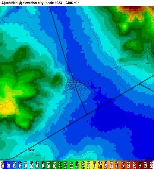
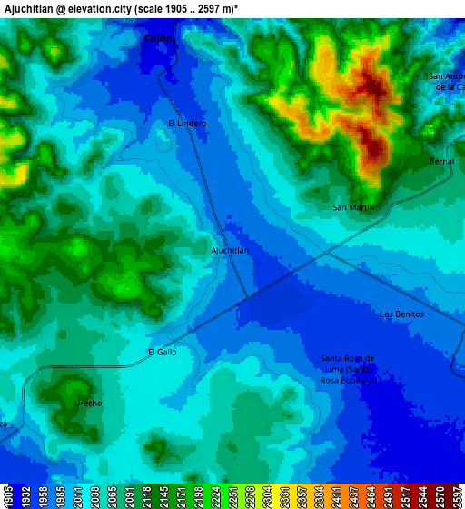
Below is the Elevation map of Ajuchitlán, which displays elevation range with different colors. Scale of the first map is from 1933 to 2406 m (6342 to 7894 ft) with average elevation of 2017.1 meters (=6618 ft) [note 1]
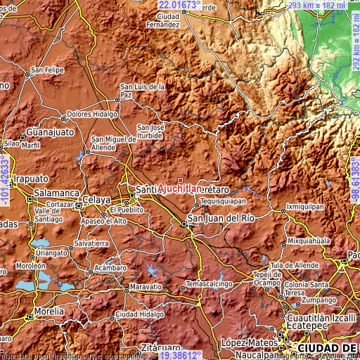
These maps also provides idea of topography and contour of this city, they are displayed at different zoom levels. More info about maps, scale and edge coordinates you can find below images.
| \ | Map #1 | Map #2 | Topo.Map |
| Scale [m] | 1933..2406 m | 1905..2597 m | × |
| Scale [ft] | 6342..7894 ft | 6250..8520 ft | × |
| Average | 2017.1 m = 6618 ft | 2050.9 m = 6729 ft | × |
| Width | 9.14 km = 5.7 mi | 18.28 km = 11.4 mi | 292.5 km = 181.8 mi |
| Height | 9.14 km = 5.7 mi | 18.28 km = 11.4 mi | 292.5 km = 181.8 mi |
| ↑Max Latitude | 20.748231° | 20.789321° | 22.01673° |
| Latitude at center | 20.70713° | 20.70713° | 20.70713° |
| ↓Min Latitude | 20.666018° | 20.624895° | 19.38612° |
| ← Min Longitude | -100.064025° | -100.107971° | -101.42633° |
| Longitude center | -100.02008° | -100.02008° | -100.02008° |
| →Max Longitude | -99.976135° | -99.932189° | -98.61383° |
Nearby cities:
Cities around Ajuchitlán sort by population:
• Colón elevation 1924 m
9.1 km,  338°
338°
• Bernal 2069 m
9 km,  65°
65°
• San Antonio de la Cal 1955 m
10.8 km,  52°
52°
• El Tejocote 2020 m
9.8 km,  188°
188°
• Esperanza 1971 m
11.7 km,  234°
234°
• San José de la Laja 1976 m
10.9 km,  154°
154°
• Urecho 2106 m
8.2 km,  223°
223°
• San José del Jagüey 2127 m
10.5 km, 71°
• Santa Rosa de Lima 1944 m
6.3 km,  136°
136°
• El Gallo 2022 m
5 km,  213°
213°
• San Martín 2099 m
5 km, 69°
• Los Benitos 1966 m
7.1 km,  110°
110°
Multilingual:
 En español:
Ajuchitlán elevación 1970 m.
 En France:
Ajuchitlán élévation 1970 m.
 Auf Deutsch:
Ajuchitlán höhe über dem Meeresspiegel ist 1970 m.

Sources and notes:
- [note 1] Map square and city borders are not equal. Map elevation data is calculated only from area inside that square.
- [src 1] Elevation data from geonames database provided with same terms of usage.
- [src 2] The elevation map of Ajuchitlán is generated using elevation data from NASA's 3 arcsec (90m) resolution SRTM data.
- [src 3] Base (background) map © OpenStreetMap contributors tiles are generated by Geofabrik and OpenTopoMap.
Copyright & License:
This Ajuchitlán Elevation Map is licensed under CC BY-SA. You may reuse any part from this page, if you give a proper credit by linking to this URL:
 More info on terms of use page.