Esperanza elevation
Esperanza (Querétaro, Colón), Mexico elevation is 1971 meters and Esperanza elevation in feet is 6467 ft above sea level [src 1]. Esperanza is a populated place (feature code) with elevation that is 657 meters (2156 ft) bigger than average city elevation in Mexico.
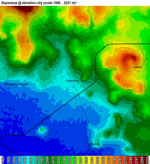
Below is the Elevation map of Esperanza, which displays elevation range with different colors. Scale of the first map is from 1908 to 2221 m (6260 to 7287 ft) with average elevation of 2008.4 meters (=6589 ft) [note 1]
These maps also provides idea of topography and contour of this city, they are displayed at different zoom levels. More info about maps, scale and edge coordinates you can find below images.
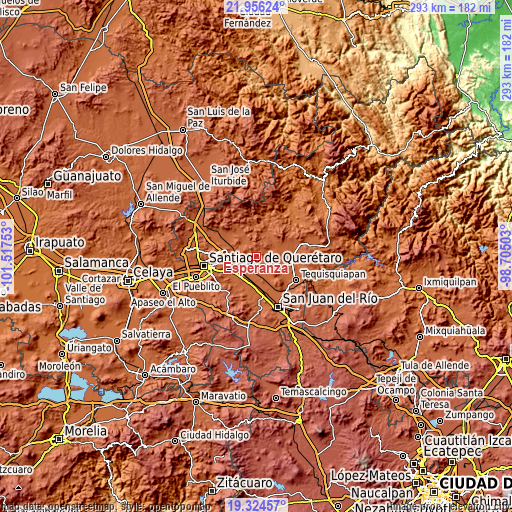
| \ | Map #1 | Topo.Map |
| Scale [m] | 1908..2221 m | × |
| Scale [ft] | 6260..7287 ft | × |
| Average | 2008.4 m = 6589 ft | × |
| Width | 9.14 km = 5.7 mi | 292.6 km = 181.8 mi |
| Height | 9.14 km = 5.7 mi | 292.6 km = 181.8 mi |
| ↑Max Latitude | 20.687217° | 21.95624° |
| Latitude at center | 20.6461° | 20.6461° |
| ↓Min Latitude | 20.604971° | 19.32457° |
| ← Min Longitude | -100.155225° | -101.51753° |
| Longitude center | -100.11128° | -100.11128° |
| →Max Longitude | -100.067335° | -98.70503° |
Nearby cities:
Cities around Esperanza sort by population:
• El Blanco elevation 1946 m
4 km,  165°
165°
• El Tejocote 2020 m
8.5 km,  110°
110°
• San Ildefonso 1926 m
10.8 km,  216°
216°
• Galeras 1920 m
5.7 km,  236°
236°
• Agua Azul 1948 m
10.9 km, 243°
• Los Cerritos 1917 m
10.6 km,  151°
151°
• Urecho 2106 m
4 km,  77°
77°
• El Gallo 2022 m
7.2 km,  68°
68°
• Noria Nueva 1909 m
10 km,  188°
188°
• Purísima de Cubos (La Purísima) 1916 m
5.1 km, 188°
• San Vicente el Alto 1922 m
10.3 km,  212°
212°
• Viborillas 1915 m
8.8 km, 241°
Multilingual:
 En español:
Esperanza elevación 1971 m.
 En France:
Esperanza élévation 1971 m.
 Auf Deutsch:
Esperanza höhe über dem Meeresspiegel ist 1971 m.

Sources and notes:
- [note 1] Map square and city borders are not equal. Map elevation data is calculated only from area inside that square.
- [src 1] Elevation data from geonames database provided with same terms of usage.
- [src 2] The elevation map of Esperanza is generated using elevation data from NASA's 3 arcsec (90m) resolution SRTM data.
- [src 3] Base (background) map © OpenStreetMap contributors tiles are generated by Geofabrik and OpenTopoMap.
Copyright & License:
This Esperanza Elevation Map is licensed under CC BY-SA. You may reuse any part from this page, if you give a proper credit by linking to this URL:
 More info on terms of use page.